1903 Scarborough Company Map of Eastern United States w/Cuba
EasternUnitedStates-scarborough-1903-2$400.00


Title
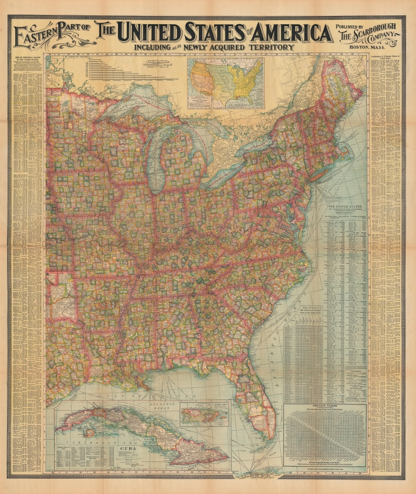
Eastern Part of The United States of America including all the Newly Acquired Territory.
1903 (dated) 41 x 35 in (104.14 x 88.9 cm) 1 : 3294720
1903 (dated) 41 x 35 in (104.14 x 88.9 cm) 1 : 3294720
Description
This is a large and colorful 1903 Scarborough map of the eastern United States. Scarborough became popular in the early 19th century due to their impressive size, high quality, and striking typography.
A Closer Look
This pocket map covers the United States East of Minnesota, Iowa, Missouri, Arkansas, and Louisiana, including parts of Nebraska, Kansas, Oklahoma, and Texas. This map notes towns, villages, and cities throughout along with individually color-coded counties by state. Rivers, railroads, shipping lines, lakes (including the Great Lakes), mountains and a host of additional topographical features are also noted.Our Colonies
The map is particularly interesting in its illustration of the newly acquired territories of the United States. A large inset of Cuba and another inset of Puerto Rico (Porto Rico) are included in the lower left quadrant of the map. As a result of the 1898 Spanish-American War, Spain ceded the Philippine Islands, Puerto Rico, and Guam to the United States, as well as relinquish sovereignty over Cuba. Cuba formally gained independence in 1902, just a few months prior to the printing of this map. Puerto Rico and Guam remain U.S. Territories. Another inset showing the territorial growth of the United States from 1776 - 1902 is included under the title.Other Details
An index of the principal places in the United States is features along the left and right borders of the map. A thematic graph shows the growth of population from 1790 to 1900. The bottom right quadrant features two tables, the first noting the time of transit of Mail between the principal cities and the second features a distance table between important points in the United States. Another index listing the area and population of states and territories, with principal cities of each, is also included.Publication History and Census
This map was published in 1903 by the Scarborough Company, Boston.Cartographer
Scarborough Company (1885 - 1913) was founded by the brothers Walter C. Scarborough (June 4, 1862 - May 9, 1904) and Howard G. Scarborough (December 23, 1867 - June 10, 1905). Walter, the older brother, was born in Providence, Rhode Island, and studied at the Boston University Law School. The Scarborough brothers founded their map publishing concern in 1885. Initially, there were three separate firms: the National Publishing Company (Portland, Maine, 1897), later based in Boston; the Dominion Publishing Company, based in Canada; and the Scarborough Publishing Company, based in London. These three firms each published semi-independently but were merged with a capital of 1,000,000 USD in 1902, subsequently publishing under the Scarborough imprint. Howard took over full management of the Scarborough in 1904 when Walter died. Howard was also in poor health, suffering from tuberculous, and relocated to Europe in 1900, where he lived in a sanatorium. He returned to the United States in 1902, settling first in Asheville, North Carolina, then at a sanatorium community in Oracle, Arizona. Until his death, he managed the Scarborough Company remotely. From about 1904, there was another branch of the firm located at 227 East Ohio Street in Indianapolis, Indiana. After Howard's 1905 death, the management of the firm, as well as its principal manufacturing and distribution points, was relocated to Indianapolis. In 1913, it became the Scarborough Motor Guide Company (c. 1913 - c. 1933). More by this mapmaker...
Condition
Very good. Minor wear along original fold lines. Slight wear along right index, where map was attached to binder. Verso reinforcement on some fold lines.
References
OCLC 49946674.