1915 Bouquet Map of Brazzaville and Environs, French Equatorial Africa (Congo)
EnvironsBrazzaville-bouquet-1915$1,200.00


Title
Environs de Brazzaville.
1915 (dated) 31.5 x 26 in (80.01 x 66.04 cm) 1 : 20000
1915 (dated) 31.5 x 26 in (80.01 x 66.04 cm) 1 : 20000
Description
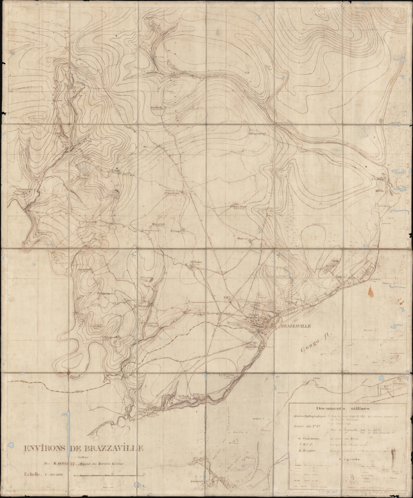
A unique survivor, this is a 1915 map of Brazzaville and its environs by Raymond Bouquet, a French colonial administrator. The ferro-gallic print process suggests it was issued in Brazzaville for administrative use, likely in less than 10 examples. Encompassing the Congo River, numerous villages, and a telegraph line, this map captures Brazzaville at the end of a period of explosive urban development, but also during World War I (1914 - 1918), when it became a staging point for French troops to wage war against German Cameroon.
A Closer Look
Brazzaville appears below and to the right of center. A street grid and individual buildings are evident. The 'Village Senegalais' is identified, and a part of the city is labeled 'Tchad', perhaps referencing a Chadian immigrants community. A mining railroad and telegraph line enter the city from the east, underscoring the ever-expanding nature of this colonial capital and its economic importance. Roads wind their way throughout, connecting Brazzaville with surrounding villages. A fishing village (village de pecheurs) is labeled near the right border in the banks of the Congo River. Contour lines depict topography. On the other side of the Congo River, Leopoldville is identified. Leopoldville became the capital of the Republic of the Congo and was renamed Kinshasa in 1966 after a nearby Nshasa village (illustrated here).Brazzaville in 1915
French Equatorial Africa was organized in 1910 and brought together Gabon, the French Congo, Oubangui-Chari (today's Central African Republic), and Chad to create the new entity. Brazzaville was French Equatorial Africa's capital. In the next few years, Brazzaville's infrastructure increased as it continued grow as a trade center. With the outbreak of World War I, trade slowed dramatically. The colony also bordered German Cameroon and a battle was fought at Mbirou in April 1914, not far from Ouesso, on the border between Cameroon and French Congo. The French and their Congolese allies were soundly defeated, with only one of the dozen or so French soldiers surviving. The soldiers from German Cameroon occupied Mbirou, but by August the soldiers from French Equatorial Africa had retaken all the lost territory. By 1915, soldiers from French Equatorial Africa had moved into German Cameroon.Ferro-Gallic Print
Ferro-Gallic printing, also called 'Iron Gall Print' is a photo-reproductive process developed in 1859 by Alphonse Louis Poitevin. The process became popular in the late 1880s when it was introduced commercially, particularly as it could be used to make fast copies of tracings and allowed for corrections to be made during the printing process. Moreover, copies could be made directly form originals without an intermediary negative process. Due to the chemicals used in this process, the background is never white, instead taking on a pale brown to lavender tint. Like most photo-reproductive processes of the period, ferro-gallic printing was useful only for short run printing, usually of less than 5 copies, and not practical for mass production. Moreover, due to the photoreactive nature of the print, and the low-quality field papers generally used, ferro-gallic prints rarely survive more than 30 years or so, making the early examples extremely scarce. The ferro-gallic process is similar to the Diazo Print or Whiteprint process, which replaced it in popularity in the early 20th century.Publication History and Census
This map was drawn by Raymond Bouquet and published in October 1915, likely in Brazzaville. This is the only known example.Cartographer
Raymond Bouquet (18xx - 19xx) was a French colonial administrator in French Equatorial Africa. He worked in the Africa from at least 1911 until at least the early 1930s. More by this mapmaker...
Condition
Fair. Dissected and mounted on linen. Wormholing and areas of loss.