1924 Poole and Union Pacific Map of Estes Park, Colorado

EstesParkColorado-poole-1924-2
$350.00
Union Pacific System Map of Rocky Mountain National (Estes) Park Denver Mountain Parks. - Main View
Processing...

1924 Poole and Union Pacific Map of Estes Park, Colorado

EstesParkColorado-poole-1924-2

One of the great National Parks.
$350.00

Title


Union Pacific System Map of Rocky Mountain National (Estes) Park Denver Mountain Parks.
  1924 (undated)     31 x 24 in (78.74 x 60.96 cm)     1 : 158400

Description


An uncommon 1924 map of Estes Park and the Rocky Mountain region west of Denver and Fort Collins issued by Poole Brothers on behalf of the Union Pacific Railroad. The map promotes travel to Denver on the Union Pacific Railroad and then continuing to Rocky Mountain National Park (Estes Park) by car. Red overprinting illustrates potential auto routes past noteworthy towns and natural wonders.
Transition to Travel by Car
The historical significance of this map is reflected in the transition from railroad to automobile travel and the era of commercial exploitation of our National Parks. Maps such as this provide a marvelous ephemeral look at the use and development of the region and often reflect roads and commercial uses (hotels, tourist attractions, etc.) which were later closed and abandoned as the management of the park system evolved away from tourist uses and became increasingly focused on the preservation and conservation of the natural resource element of the parks.
Publication History and Census
This map was issued by the Chicago firm Poole Brothers. Variants were issued from at least 1921 until at least 1926, with the present example likely dating to 1924. The 1924 edition appears in 13 institutional collections across the United States.

Cartographer


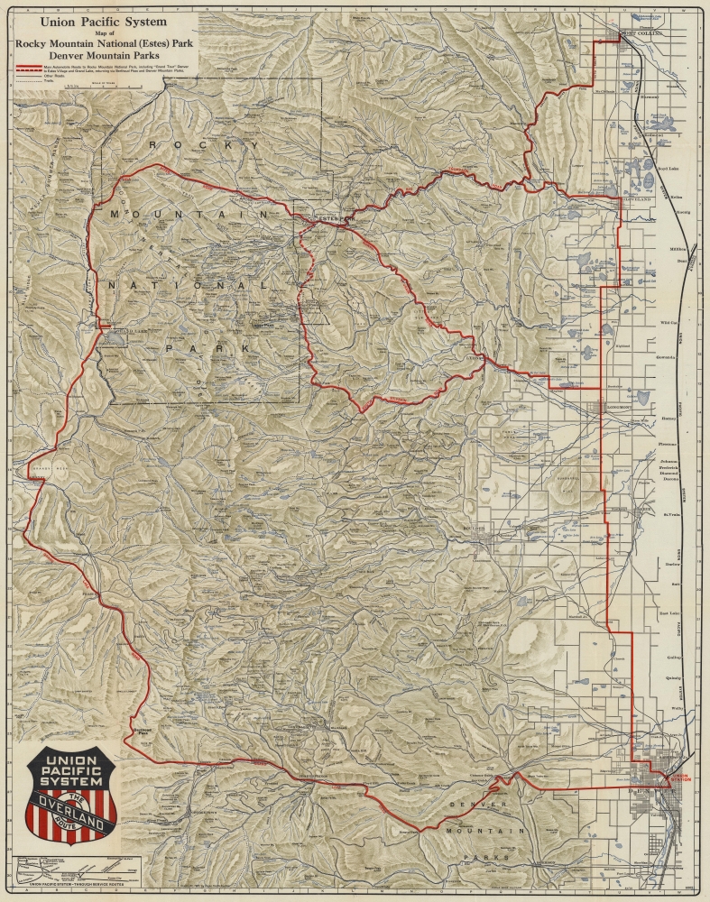
Poole Brothers (fl. c. 1880 - 1968) were a Chicago based firm active in the late 19th and early 20th century with an initial focus on promotional railroad maps. Poole Brothers was founded by George Amos Poole, one of the original four partners in the firm that would become Rand McNally, and his brother William H. Poole. Poole started his own firm, Poole Brothers, as a direct competitor to Rand McNally for the lucrative railroad business. Like many of its competitors, Poole Brothers maintained an office on Chicago's Printer's Row (downtown Loop district). Nevertheless, the two firms, along with Cram and Company, seem to have come to an accord, at least with regard to price-fixing, for which they were cited by the Federal Trade Commission in 1948. Their earliest known work is an 1880 map of Yellowstone National Park. Afterward they went on to produce a vast range of maps and other print products including tickets, cards, coupons, and restaurant menus. In time Poole Brothers merged with Newman-Randolph, which was then acquired by the American Can Company in the early 1960s. The American Can Company liquidated its printing concerns later in the same decade. More by this mapmaker...

Condition


Good. Closed tear extending two inches into printed area in upper left corner near title professionally repaired on verso. Verso repairs to fold separations and at fold intersections. Small area of loss in upper left quadrant.

References


OCLC 53257665.