This item has been sold, but you can get on the Waitlist to be notified if another example becomes available, or purchase a digital scan.
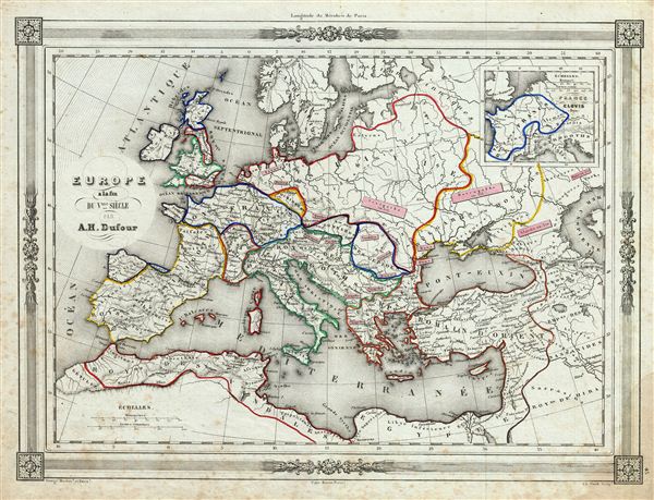
1852 Dufour Map of Europe at the end of the 5th Century
EuropeFifthCentury-dufour-1852$75.00

Title
Europe a la fin du V.me Siecle.
1859 (undated) 10 x 13 in (25.4 x 33.02 cm)
1859 (undated) 10 x 13 in (25.4 x 33.02 cm)
Description
An uncommon and extremely attractive 1852 map of europe at the end of the fifth Century. The map covers from modern day United Kingdom to Russia, and south to include part of egypt, and the Barbary Coast. The map includes parts of what are today Turkey, Russia and Syria. An inset on the top right corner details France under the rule of Clovis, c.510. Throughout, the map identifies various cities, towns, rivers and assortment of additional topographical details. The map depicts europe after the so-called Barbarian Invasions, which saw the Western Roman empire fall to Ostrogoths, Visigoths, Goths, Vandals, Saxons and much of central and northern europe under the sway of Attila and his merry Huns. Historians now also use the term 'Barbarian Invasions' to refer to the simultaneous and more peaceable migration of Germanic peoples westward, including the first Anglo-Saxon settlement of Britain, when, for all intents and purposes, the Roman empire had ceased to exist. The map features a beautiful frame style border. Prepared by A. H. Dufour for publication as plate no. 43 in Maison Basset's 1852 edition of Atlas Illustre Destine a l'enseignement de la Geographie elementaire.
CartographerS
Adolphe Hippolyte Dufour (1795 - 1865), also known as Auguste-Henri Dufour, was a Paris based map and atlas publisher active in the middle to late 19th century. Dufour claimed to be a student of another French cartographer, Emile Lapie. He is known to have worked with numerous other French cartographers, publishers, and engravers of the period including Andriveau-Goujon, Charles Dyonnet, and Duvotenay. His corpus includes numerous maps and atlases, the most striking of which is probably his monumental elephant folio Atlas Universel Physique, Historique et Politique Geographie Ancienne et Moderne. Dufour's student and successor was Alexandre Vuillemin. More by this mapmaker...
Jean Denis Barbie du Bocage (1760 - 1825) and his son Jean-Guillaume Barbie du Bocage (1795 - 1848) were French cartographers and cosmographers active in Paris during late 18th and early 19th centuries. The elder Barbie du Bocage, Jean Denis, was trained as a cartographer and engraver in the workshops of mapmaking legend J. B. B. d'Anville. At some point Jean Denis held the post of Royal Librarian of France and it was through is associations with d'Anville that the d'Anville collection of nearly 9000 maps was acquired by French Ministry of Foreign Affairs. The younger Barbie du Bocage, Jean-Guillaume, acquired a position shortly afterwards at the Ministry of Foreign Affairs and, in time, became its head, with the title of Geographe du Ministere des Affaires Etrangeres. Learn More...
Source
Barbie du Bocage, J. D., Atlas Illustre Destine a l'Enseignement de la Geographie Elementaire, (Paris: Maison Basset) 1852.
Condition
Very good. Blank on verso. Minor foxing throughout.