A scarce 1879 plat map of Falls County, Texas produced by the Texas General Land Office. It provides a detailed portrait of the county roughly thirty years after its creation.
A Closer Look
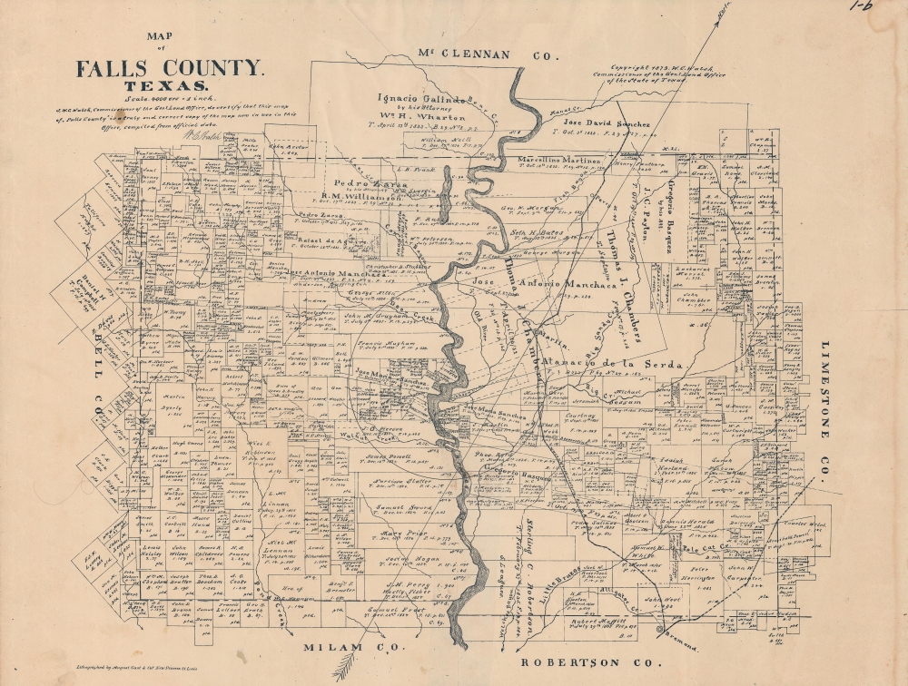
Individual landholders are noted throughout with their plots outlined. For older plots, predating the Texas Revolution, the date of acquisition is noted. The Brazos River runs down the center of the map, dividing the county in half, while creeks and other waterways are also noted. A large arrow points to the north, indicating that the map is oriented towards the northwest. A dashed line marks the county border, with many plots straddling the line between Falls and neighboring counties.Rails through Texas
The Waco and Northwestern Railroad runs roughly parallel to the Brazos on its east bank. It was planned as a means of connecting Waco with the Houston and Texas Central Railway, which linked Houston and Dallas. Though chartered in 1866, progress was slow, and the relatively short line was not completed until 1872, with the two lines meeting at Bremond, at bottom towards right, just beyond the county line into Robertson County.
The choice of this location was no accident, as the land there was owned by Paul Bremond, the founder of the Galveston and Red River Railroad, which later became the Houston and Texas Central. Despite this early and notable success, Bremond's later ventures were not as fortunate and he invested most of his money into the misguided Houston East and West Texas Railway, a narrow-gauge track meant to link Houston, Texarkana, and points throughout Texas and the South, though only a small portion of it was built.Local History
Sterling C. Robertson, whose descendants still held land along the river at bottom when this map was produced, was an empresario from Tennessee who received a grant from the Coahuila y Tejas legislature to establish a settlement. Known as Nashville Colony or Robertson's Colony, it encompassed a wide section of north-central Texas (some thirty modern-day counties), but its capital was in what became Falls County, at Sarahville de Viesca, near the later town of Marlin. A fort (Fort Milam) was constructed nearby along the river, just to the south of the area seen here, and another town named Bucksnort emerged in the late 1830s, offering shops and services to travelers en route to Dallas or other fairly distant destinations (like Sarahville de Viesca, Bucksnort quickly became a ghost town, explaining its absence here).
Hundreds of families of settlers came to the region from Tennessee, Alabama, and Mississippi, but the colony's early history was beset by fighting with Native Americans and it was abandoned in the 'Runaway Scrape' during the Texas Revolution. After the revolution and union with the United States of America, Falls County was established in 1850, with a county seat at Adams. However, soon afterwards, Adams was renamed Marlin, in honor of John Marlin, an Irish-born colonist who arrived in the area in 1835 and became an alcalde under Mexican rule. Though Marlin was an early settler on the land, Thomas Chambers soon came to own the area surrounding the town and his descendants retain it here.
The county is named for a waterfall that existed on the Brazos River until 1866, when a storm caused the river to change course (from the 'Old River' seen here) and a new waterfall emerged slightly upriver from the original one.Publication History and Census
This map was prepared by the Texas General Land Office and printed by August Gast and Co. in 1879. We note it among the holdings of the Library of Congress, the University of Houston, and the Daughters of the Republic of Texas Library. It has no known history on the market.
CartographerS
The Texas General Land Office (GLO) (December 22, 1836 - Present) is an agency of the state government of Texas responsible for the management of land and mineral rights that are owned by the state. Established by the Congress of the Republic of Texas on December 22, 1836, the agency manages Texas's publicly owned land, negotiates and enforces leases concerning the use of that land, and sells public lands. Part of these proceeds are put into the state's Permanent School Fund, which helps fund public education in Texas. The GLO has managed The Alamo in San Antonio since 2011. After Texas was annexed by the United States in 1845, the state maintained control over all its public lands from when it had been a sovereign state, making Texas the only U.S. state to control all its own public lands. All federal land in Texas was acquired either through purchase (for example military bases) or donation (national parks). More by this mapmaker...
August Herman Ludwig Gast (March 10, 1819 - December 24, 1891) was a German-American lithographer. Born in Lippe Detmold, Germany, was educated there, and went into the lithography business with his brother Leopold (March 11, 1810 - March 1, 1898). After participating in the Revolution of 1848, the brothers emigrated to the United States and arrived in New Orleans and, of course, they brought their lithography press with them. them. The duo worked in New York City for a few months, and then spent over a year in Pittsburgh before settling in St. Louis, Missouri in 1852. In St. Louis the brothers founded Leopold Gast and Brother Lighograph Company, which Leopold ran until he sold his share of the business to August in 1866. After Leopold's departure, Gast continued to grow his lithography business, now called August Gast and Company, until he sold it in 1885, when it was one of the largest firms of its kind in the country. After the sale, Gast founded the August Gast Bank Note and Lithograph Company and the Gast Wine Company. Gast died of 'la grippe' in St. Louis at the age of 72. He married his wife Sophie von Laer in 1853. Tragically, Sophie died in 1864. At some point thereafter, Gast married Marie Barthel, with whom he had thirteen children, of whom only four were alive at the time of August Gast's death. Following Gast's death, his son Ferdinand takes over the businesses, and the Gast Wine Company is absorbed by the Gast Brewing Company in 1900. The Gasts continue to prosper and found the Gast Building and Realty Company in 1944, and Ferdinand's grandsons, Ferd Gast and Robert Gast, invest in and develop real estate. Robert created several companies over his lifetime, including those that invest in single family homes and ones to develop, build, and operate amusement parks. Doug Gast, Robert's son, stars a financial investmentsd business in the 1960s, followed by Gast Webbing Restraints in the 1980s, which manufactured automotive parts. By the 2000s, the third generation of Gasts are involved in the family real estate business, and today Gast Companies has consolidated in order to manage their diverse portfolio. Learn More...
Good. Soiling along right edge and sporadically in the margins. Creasing in top and right margin. Even toning.
OCLC 67526250.