
Texas General Land Office

The Texas General Land Office (GLO) (December 22, 1836 - Present) is an agency of the state government of Texas responsible for the management of land and mineral rights that are owned by the state. Established by the Congress of the Republic of Texas on December 22, 1836, the agency manages Texas's publicly owned land, negotiates and enforces leases concerning the use of that land, and sells public lands. Part of these proceeds are put into the state's Permanent School Fund, which helps fund public education in Texas. The GLO has managed The Alamo in San Antonio since 2011. After Texas was annexed by the United States in 1845, the state maintained control over all its public lands from when it had been a sovereign state, making Texas the only U.S. state to control all its own public lands. All federal land in Texas was acquired either through purchase (for example military bases) or donation (national parks).
One of the original Texas counties.
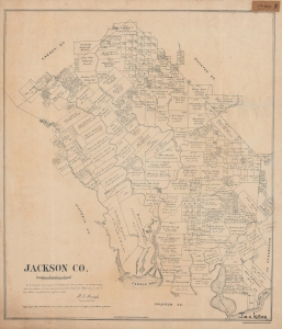
Jackson Co.
$350.00
Acquire
- Digital Map Information
- Suitable for large format printing
- File Size: 20.69 MB
- File Type: ZIP / TIFF
- ICC color profile embedded
- Delivered instantly via download link
A rare 1880 plat map of Jackson County, Texas, produced by the Texas General Land Office and printed (lithographed) by August Gast. It depicts the county on the eve of an important transformation brought by the railroad. (more details)
Veterans Land Board Scandal.
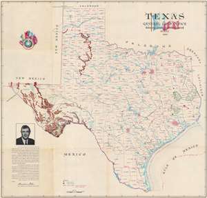
This is a 1954 Texas General Land Office and Eltea Armstrong map of Texas. The map features a portrait of Bascom Giles at the height of his power as head of the Texas Land Office, and just months before his fall in the Veterans Land Board Scandal. Austin, Dallas, Fort Worth, Abilene, Houston, and San Antonio, are emphasized by 'street grids' relating their relative size. Green areas highlight national forests and Big Bend National Park. Mountains in West Texas are illustrated pictorially. State parks and forests are indicated by green pine trees. (more details)