This item has been sold, but you can get on the Waitlist to be notified if another example becomes available, or purchase a digital scan.
1860 Norie Nautical Map of the Cape of Good Hope / False Bay, South Africa
FalseBaySouthAfrica-norie-1860$1,000.00

Title
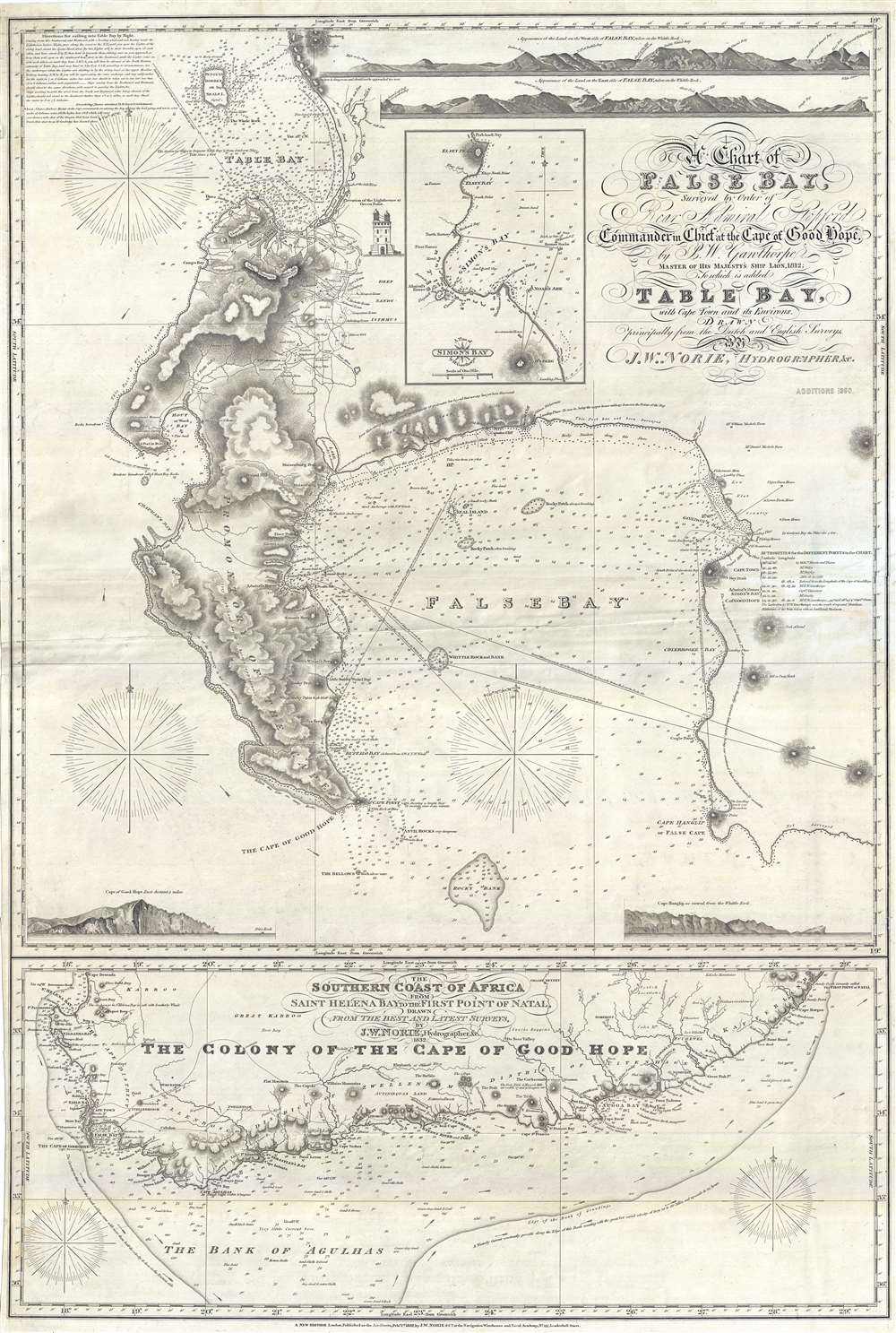
A Chart of False Bay Surveyed by Order of Rear Admiral Stopford, Commander in Chief at the Cape of Good Hope, by P. W. Gawthorpe, Master of His Majesty's Ship Lion, 1812; to which is added Table Bay, with Cape Town and its Environs.
1860 (dated) 39 x 26 in (99.06 x 66.04 cm) 1 : 100000
1860 (dated) 39 x 26 in (99.06 x 66.04 cm) 1 : 100000
Description
A remarkable and very rare 1860 British commercial nautical chart of False Bay and the Cape of Good Hope, South Africa. Issued by John William Norie, this map is based upon surveys ordered by Sir Robert Stopford during his time as Commander-in-Chief of the Cape of Good Hope Station (1810 – 1827). The chart depicts from Robben Island south to the Cape of Good Hope and False Cape, including Rocky Bank. False Bay and the Promontory of the Cape are illustrated in full. In the vicinity of Cape Town, the map offers exceptional inland detail, identifying numerous private estates by the name of their owners, along the various rivers between Table Bay and False Bay. An inset of Simon's Bay appears in the upper right, near the title area, with important buildings identified.
Secondary Map
Beneath the main chart of False Bay, there is a secondary map of the Cape Colony extending from the Cape District in the west to Cape Morgan and the Sandy Point or 'First Point of Natal.' This map offers limited inland cartography including major mountains, roads, and riverways. Some towns are noted, among them are De Beer Valley, Somerset, various forts, 'Gaikas Residence,' Zwellendam, Worchester, Setllenbosch, Caledon, and more.Marine Navigation Details
Throughout both maps there are detailed depth soundings and curious annotations relating maritime and other information. Nighttime sailing directions into Table Bay appear in the upper left. There is an illustration of the lighthouse at Green Point. The map is further embellished by four land profiles.Blueback Charts
Blueback nautical charts began appearing in London in the late 18th century. Bluebacks, as they came to be called, were privately published large format nautical charts known for their distinctive blue paper backing. The backing, a commonly available blue manila paper traditionally used by publishers to warp unbound pamphlets, was adopted as a practical way to reinforce the low-quality paper used by private chart publishers in an effort to cut costs. The earliest known blueback charts include a 1760 chart issued by Mount and Page, and a 1787 chart issued by Robert Sayer. The tradition took off in the early 19th century, when British publishers like John Hamilton Moore, Robert Blachford, James Imray, William Heather, John William Norie, Charles Wilson, David Steel, R. H. Laurie, and John Hobbs, among others, rose to dominate the chart trade. Bluebacks became so popular that the convention was embraced by chartmakers outside of England, including Americans Edmund March Blunt and George Eldridge, as well as Scandinavian, French, German, Russian, and Spanish chartmakers. Blueback charts remained popular until the late 19th century, when government subsidized organizations like the British Admiralty Hydrographic Office and the United States Coast Survey, began issuing their own superior charts on high quality paper that did not require reinforcement.Publication History and Census
Norie originally issued this chart in 1832. The present example offers updates to 1860 and so must have been issued posthumously by Norie's heirs. Evidence suggests that there were most certainly intermediary variants published, but nevertheless this is the only example of this chart we have been able to positively identify in any collection public or private. A unique rarity.Cartographer
John William Norie (June 3, 1772 - December 24, 1843) was a British teacher of navigation, hydrographer, chart maker, and publisher of maritime manuals active in London, England in the late 18th and early 19th centuries. Norie was born in Wapping, London, an area long associated with the maritime sciences. Norie's career as a chart maker commenced under the tutelage of William Heather, a prominent purveyor and publisher of nautical charts, pilot books, and navigational tools who took over the firm of Mount and Page in 1765. Heather and Norie were likely acquainted through John Hamilton Moore, another important chart maker with whom both seem to have been associated early in their careers. Heather hired Norie to teach basic navigation at his shop at 157 Leadenhall Street. Under Heather Norie also distinguished himself as a draftsman, completing many of the early charts associated with the Heather firm. When Heather died in 1812 John Norie partnered with George Wilson, a moneyed 'man about town' with little experience in the maritime trades, to acquire the map and chart business at 9500 British Pounds. It proved a good deal for Norie, who retained all copyright privileges and drew 1/4 quarter share of business profits, as well an impressive quarterly salary and, for doing all of the work, 1/3rd of Wilson's share. The firm, referred to as the 'Naval Warehouse' quickly acquired a reputation for quality navigational materials and became a favorite of merchant seamen. It was even referenced in Charles Dickens' classic novel Dombey and Son. In 1819, Norie and Wilson acquired the failing chart business of David Steel, which significantly increased the size, though not quality, of their chart catalogue. With the rise of the British Admiralty and its own maritime chart productions, the business of "Chart Purveyor" in London dramatically changed. Admiralty charts and pilot books, designed for military use, were offered through established intermediaries, like Norie, at bargain prices. Most chart makers of the period found it profitable to use the highly technical Admiralty charts to update their own more decorative vernacular charts. For a brief time this practice proved exceptionally profitable but eventually began to draw criticism. Nonetheless, Norie retired to Edinburgh in 1840 and died a wealthy man in 1843. In 1840 the business passed to a nephew of George Wilson, Charles Wilson, who renamed the firm "Norie & Wilson". William Heather Norie, J. W. Norie's own son, produced few charts, instead pursuing a career in the legal field. Norie & Wilson merged with James Imray's prosperous chart business in 1899, becoming Imray, Laurie, Norie & Wilson, a profitable concern that remains active in the maritime charting industry. More by this mapmaker...
Condition
Very good condition. Some minor restoration.
References
OCLC 871367685.