An example of Frederick W. Beers' 1867 detailed hand-colored map of the town of Fishkill, New York, along the Hudson River.
A Closer Look
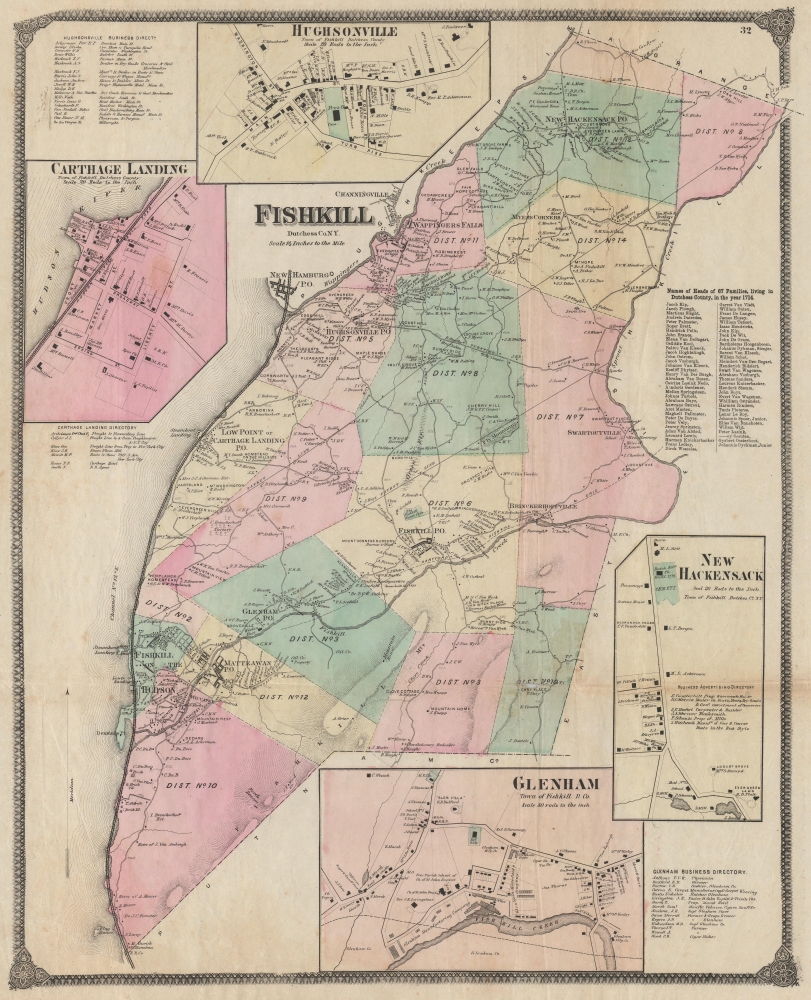
Coverage includes the contemporary town of Fishkill, including today's city of Beacon, in the southwest corner of Dutchess County, New York, along the Hudson River. The town is divided into districts, which are color-shaded for easy distinction. Villages and hamlets, including the eponymous village of Fishkill, are typically denoted by a post office, while schools, industrial works, cemeteries, steamboat landings, and other features are labeled throughout. Numbers along roads provide distances. The map is so detailed that individual buildings and properties are recorded, along with their owners. The Hudson River Railroad, which began operations along its full length in 1851, appears at left along the river, while the Hartford, Fishkill, and Erie Railroad appears as proposed near center, though, like the Hudson River Line, it was held up for many years before completion.
Two 'patent lines' run northeast from the river. These refer to the Nine Partners' Patent, a 1697 land grant by New York governor Benjamin Fletcher, one of several made around the turn of the 18th century that divvied up much of the Hudson River shoreline. More recent historical references also appear, notably the 'Revolutionary Redoubts' towards bottom-center. (This was the main supply depot for the Continental Army in the northern colonies during the Revolutionary War.) Nearby Mount Beacon received its name because the revolutionaries would light signal fires there to communicate with each other.
Four inset maps appear, displaying the hamlets of Carthage Landing, Hughsonville, New Hackensack, and Glenham in greater detail and providing a business directory for each. A table at right lists the names of the heads of families living in Dutchess County in 1714, with an overwhelming majority bearing Dutch names, including well-known families such as Knickerbocker, Kip, and Dyckman.Publication History and Census
This map was prepared by Frederick William Beers and published in 1867 in the Atlas of New York and Vicinity from Actual Surveys. Six printings of this atlas were issued in 1867, which differ considerably from one another (analyzed in Barbara McCorkle's 1990 article 'The Strange Case of E.W. Beers and the Atlas of New York and Vicinity'). The present map appeared in two of these printings (see Rumsey 0063.035 and 4631.035).
CartographerS
The Beers family (Fredrick, Silas, James and Daniel) (fl. c. 1850 - 1886), along with Charles and Augustus Warner, were prominent map publishers working from the 1850s to the late 1880s. Often publishing under the Warner & Beers designation, the combined firms produced a series of important state and county atlases and map of much of the northeastern United States. Many of their regional maps are among the most detailed and well laid out maps ever produced of their respective regions. Because Warner & Beers county maps were often detailed down to the individual homes and landowners, they have become highly sought after by general and family historians. In additional to producing maps of surpassing detail, Warner & Beers also maintained an earlier generation's attention to detail and quality while publishing in an era ever increasingly dominated by the low cost printing methods used by the publishing empires of Rand McNally and George Cram. More by this mapmaker...
Frederick William Beers (August 17, 1839 - September 8, 1933) was an American map publisher, cartographer, and surveyor. Beers was born in Maryland, the son of map publisher James Botsford Beers (October 16, 1811 - June 3, 1901), but lived much of his life in New York where he was the chief of the map division and Commissioner of Public Records in Brooklyn. He joined the family business in 1870 and along with his father, published the Farm Line Atlas of the County of Kings and the Atlas of Long Island. He is credited with personally mapping every county in New York State. Frederick worked with his family into the mapmaking trade, including his brother, Charles Henry Beers (November 3, 1813 - March 5, 1892), and nephews Silas Norman Beers (September 3, 1837 - May 12, 1873) and Daniel Glover Beers (October 19, 1841 - February 12, 1913). He retired from the publishing business in 1930, when he was more than 90 years old. He died on September 8, 1933 in Bridgeport, Connecticut. Learn More...
Source
Beers, F. W., Atlas of New York and Vicinity, (New York: Beers, Ellis, Soule) 1867.
Good. Some toning and creasing along old fold lines.
Rumsey 0063.035. Barbara McCorkle, 'The Strange Case of E.W. Beers and the Atlas of New York and Vicinity' (Meridian, 5:39-43).