1867 Beers Map of Fishkill on the Hudson and Matteawan, Beacon, New York

FishkillMatteawan-beers-1867
$450.00
Fishkill on the Hudson / Matteawan. - Main View
Processing...

1867 Beers Map of Fishkill on the Hudson and Matteawan, Beacon, New York

FishkillMatteawan-beers-1867

Hamlets along the Hudson.
$450.00

Title


Fishkill on the Hudson / Matteawan.
  1867 (undated)     23.5 x 23.5 in (59.69 x 59.69 cm)     1 : 4950

Description


An example of Frederick W. Beers' hand-colored map of Fishkill on the Hudson and Matteawan, consistent with the present-day city of Beacon, New York. The remarkably detailed map provides information on individual properties and businesses, along with their owners, making it an essential source of information on local history.
A Closer Look
Coverage includes the hamlets of Fishkill on the Hudson (sometimes as Fishkill-on-the-Hudson) and Matteawan, corresponding to today's city of Beacon (named for the signal fires on nearby hills used by Continental forces during the Revolutionary War). Individual residential and commercial properties are labeled throughout, with their owners' names listed. Among the residents were General J. (Joseph) Howland, at bottom, who served with distinction during the U.S. Civil War, though his term as commander of the 16th New York Infantry Regiment was brief, due to a wound at the Battle of Gaines' Mill. Schools, cemeteries, offices, and industrial works are similarly noted. One significant inclusion is the 'Lone Star Base Ball Grounds' at top-right, reflecting the growing popularity of the sport in the region around New York City. Rail lines belonging to the Hudson River Railroad run north-south at left, while an office for the Boston, Hartford, and Erie Railroad hints at the long-discussed but also long-delayed effort to link the Hudson at Fishkill to New England by rail. Surrounding the map is a business directory for the two hamlets.
Publication History and Census
This map was prepared by Frederick William Beers and published in 1867 in the Atlas of New York and Vicinity from Actual Surveys. Six printings of this atlas were issued in 1867, which differ considerably from each other (analyzed in Barbara McCorkle's 1990 article 'The Strange Case of E.W. Beers and the Atlas of New York and Vicinity'). The present map appeared in two of these printings (see Rumsey 0063.036 and 4631.036).

CartographerS


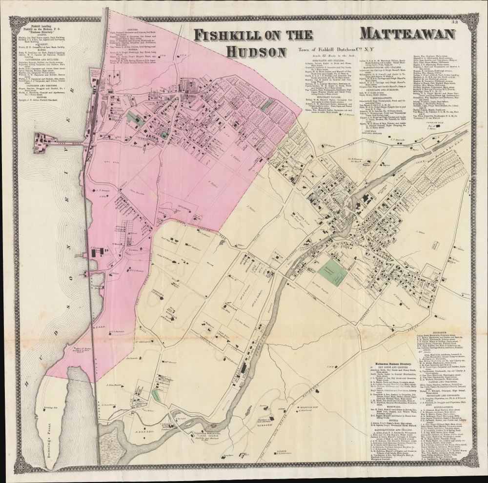
The Beers family (Fredrick, Silas, James and Daniel) (fl. c. 1850 - 1886), along with Charles and Augustus Warner, were prominent map publishers working from the 1850s to the late 1880s. Often publishing under the Warner & Beers designation, the combined firms produced a series of important state and county atlases and map of much of the northeastern United States. Many of their regional maps are among the most detailed and well laid out maps ever produced of their respective regions. Because Warner & Beers county maps were often detailed down to the individual homes and landowners, they have become highly sought after by general and family historians. In additional to producing maps of surpassing detail, Warner & Beers also maintained an earlier generation's attention to detail and quality while publishing in an era ever increasingly dominated by the low cost printing methods used by the publishing empires of Rand McNally and George Cram. More by this mapmaker...


Frederick William Beers (August 17, 1839 - September 8, 1933) was an American map publisher, cartographer, and surveyor. Beers was born in Maryland, the son of map publisher James Botsford Beers (October 16, 1811 - June 3, 1901), but lived much of his life in New York where he was the chief of the map division and Commissioner of Public Records in Brooklyn. He joined the family business in 1870 and along with his father, published the Farm Line Atlas of the County of Kings and the Atlas of Long Island. He is credited with personally mapping every county in New York State. Frederick worked with his family into the mapmaking trade, including his brother, Charles Henry Beers (November 3, 1813 - March 5, 1892), and nephews Silas Norman Beers (September 3, 1837 - May 12, 1873) and Daniel Glover Beers (October 19, 1841 - February 12, 1913). He retired from the publishing business in 1930, when he was more than 90 years old. He died on September 8, 1933 in Bridgeport, Connecticut. Learn More...

Source


Beers, F. W., Atlas of New York and Vicinity, (New York: Beers, Ellis, Soule) 1867.    

Condition


Good. Some toning and creasing along old fold lines. Minor loss at fold intersection in lower right. Stabilized with archival tissue on verso.

References


Rumsey 0063.036. Barbara McCorkle, 'The Strange Case of E.W. Beers and the Atlas of New York and Vicinity' (Meridian, 5:39-43).