This item has been sold, but you can get on the Waitlist to be notified if another example becomes available, or purchase a digital scan.
1845 First Edition Joseph Meyer Map of Florida
Florida-meyer-1845$175.00

Title
Florida. Nach en besten Quellen bearbeitet 1845.
1845 (dated) 15.5 x 12.5 in (39.37 x 31.75 cm) 1 : 3100000
1845 (dated) 15.5 x 12.5 in (39.37 x 31.75 cm) 1 : 3100000
Description
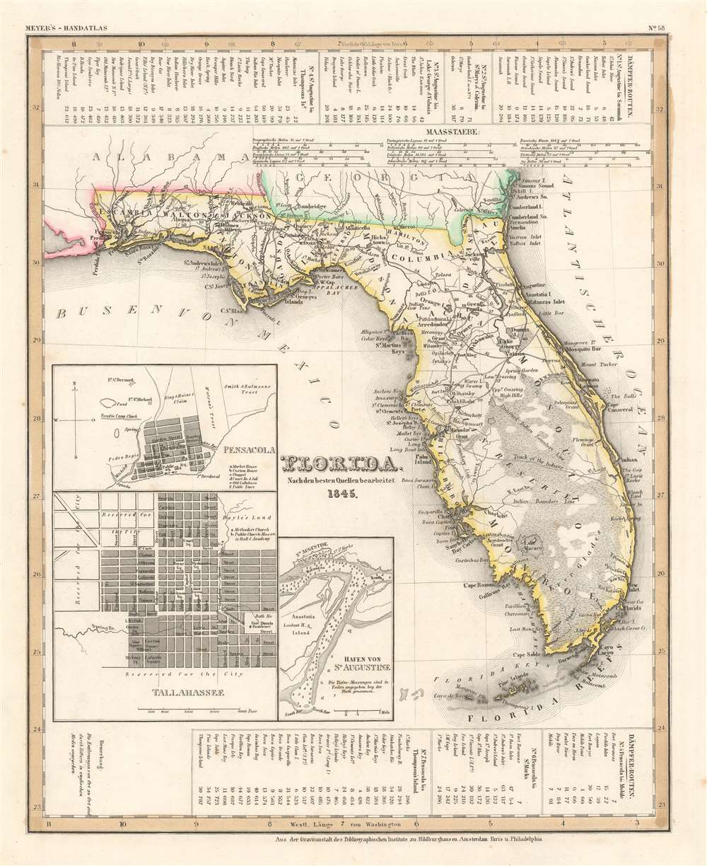
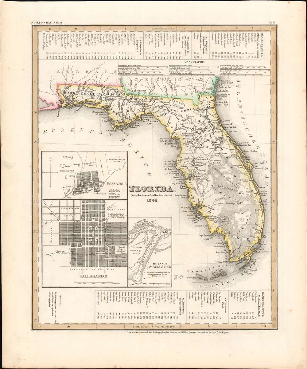
This is a first edition 1845 Joseph Meyer map of Florida. Granted statehood on March 3, 1845, this map likely ranks among the first published maps of Florida as a state. Derived from maps by David Tanner, this map illustrates Florida early in its statehood during the Second Interbellum, a period of relative peace between the Second and Third Seminole Wars. Cities and counties throughout are labeled, along with both the Arredondo and Miranda land grants. In addition to Arredondo's famous large grant in central Florida, a secondary Arredondo holding is noted near modern day Fort Meyers. Tables along the top border chronicle four steamship routes, and another three are included along the bottom border. Inset maps in the lower left quadrant detail Saint Augustine, Tallahassee, and Pensacola.
The Seminole were a composite tribe formed from various southeastern American Indian tribes that were relocated to a large reservation in Central Florida. These included the Alabamas, Choctaw, Yamasees, Yuchis and Creek people, as well as escaped slaves.
In 1834 the United States government forced the Seminole to sign the Treat of Payne's Landing, which gave the tribe three years to move west of the Mississippi and join the Creek Tribe. The Seminole, rightly claiming unfair negotiations, renounced the treaty and, instead of moving west, entrenched themselves in the Florida swamps. The subsequent war proved long and bloody, with neither side gaining a solid advantage. Ultimately, the superior resources and numbers of the United States military proved decisive. Most of the Seminole were removed to the Indian Territory (Oklahoma) while the remaining Seminole in Florida removed to a large informal reservation located between Lake Okeechobee and Tampa.
Second Seminole War
Fought between 1835 and 1842, the Second Seminole War was a conflict between the United States Government and the various groups of American Indian groups known collectively as the Seminole. Focused primarily in peninsular Florida, the Second Seminole War was the most significant of the three Seminole Wars, and the longest Indian War in U.S. history.The Seminole were a composite tribe formed from various southeastern American Indian tribes that were relocated to a large reservation in Central Florida. These included the Alabamas, Choctaw, Yamasees, Yuchis and Creek people, as well as escaped slaves.
In 1834 the United States government forced the Seminole to sign the Treat of Payne's Landing, which gave the tribe three years to move west of the Mississippi and join the Creek Tribe. The Seminole, rightly claiming unfair negotiations, renounced the treaty and, instead of moving west, entrenched themselves in the Florida swamps. The subsequent war proved long and bloody, with neither side gaining a solid advantage. Ultimately, the superior resources and numbers of the United States military proved decisive. Most of the Seminole were removed to the Indian Territory (Oklahoma) while the remaining Seminole in Florida removed to a large informal reservation located between Lake Okeechobee and Tampa.
The Second Interbellum (1842 - 1855)
The Second Interbellum is the name given to the period of time between the Second and Third Seminole Wars. During this era, the Seminole remaining in Florida (the rest had either been forcibly removed or bribed into moving to Indian Territory, modern-day Oklahoma) were assigned an unofficial reservation, occupying part of southwestern Florida here marked here by thin dashed lines. At the time it was estimated that 120 warriors, 100 women, and 140 children were all that remained of the once extensive Florida American Indian population. Although limited trade occurred, most American Indians then in Florida limited contact with white settlers. After a period of relative peace, a band of 'ousiders' (Seminole that chose not to live on the unofficial reservation) attacked a settlement. Two separate attacks in July 1849 increased tension, and the U.S. Army demanded the murderers be turned over. A year later, an orphaned boy was killed on his farm, supposedly by Indians. This killing drove the U.S. government to demand the deportation of all American Indians from Florida, a decree that led to the Third Seminole War.Arredondo and Miranda Land Grants
Two land grants, Arredondo's Grant and Miranda's Grant, are holdovers from Spanish Florida. Beginning in the 1790s, the Spanish crown offered land grants to people courageous enough to emigrate to Florida or for meritorious service to the crown. Arredondo's grant, named after Fernando de la Maza Arredondo (c. 1760 - 18??), is located to the west of St. Augustine in Alachua county. It was granted to Arredondo in 1817 by Alexander Ramirez of Havana. Miranda's Grant, after Pedro Miranda, a Spanish sailor, is in the vicinity of modern-day Tampa. After Florida became a possession of the United States in 1821, these grants became a point of contention between the United States government and the grantees. Initially, the U.S. government declared that it would honor the grants as long as the owner could prove their legitimacy. Both Pedro Miranda and Fernando de la Maza Arredondo took their cases to the United States Supreme Court, where their rights to the land were affirmed. Eventually, nonetheless, both grants were dissolved by U.S. courts on the basis that they were not properly developed and therefore forfeited.Publication History and Census
This map was created by Joseph Meyer and published in the 1845 edition of his Meyer's Zeitung Atlas. Curiously, the publication information provided below the bottom border lists Heidelberg, Amsterdam, Paris, and Philadelphia as cities of publication, suggesting that Meyer had publishing agreements with atlas publishers in France, Holland, and the United States. Meyer published two editions of his atlas: the first in 1845 and a second in 1850. Examples are part of the Touchton Map Library at the Tampa Bay History Center and the David Rumsey Map Collection.CartographerS
Joseph Meyer (May 9, 1796 - June 27, 1856) was a German industrialist, merchant, and publisher, active in Germany in the early to mid 19th century. He is best known for publishing the encyclopedia Meyers Conversation-Lexicon. Born in Gotha, Germany, Meyer was educated as a merchant in Frankfurt am Main. He moved to London in 1816, but returned to Germany in 1820 after his stock speculations and business adventures fell through. Once back in Germany, he began by investing in the textile trade (1820 - 24). Meyer began creating business plans concerning how to start railways soon after the first steam-hauled railway began operation in December 1835. He founded the Deutsche Eisenbahnschienen-Compangie auf Actien (German Railway Rail joint stock company) in 1845. Meyer also found great success as a publisher, utilizing the system of serial subscriptions to publications, a new idea for the time. He founded a company, Bibliographisches Institut in Gotha in 1825, which published several versions of the Bible, works of classical literature, atlases, the world in pictures on steel engravings, and an encyclopedia. He moved the Institut from Gotha to Hildburghausen in 1828. He published several atlases, including Meyer's Groẞer Hand-Atlas (1843 - 1860). In 1848, he supported the Springtime of the Peoples Revolutions that took place throughout Germany and much of Europe. When the revolutions failed in 1849, Meyer was briefly imprisoned for his support of revolutionary activities. The revolutions also began to take a toll on Meyer's business interests, and when he died, in 1856, the Bibliographisches Institut was struggling financially. His son, Herrmann Julius Meyer, took over the firm, spearheading a rapid recovery. This, and other businesses prospered under Herrmann Julius (April 4, 1826 - March 12, 1909) and when he died in 1909, he led the richest family in Saxony, with more total wealth than the King of Saxony More by this mapmaker...
Henry Schenck Tanner (1786 - May 18, 1858) was one of the preeminent American map engravers and publishers of the early 19th century - what is considered to be the "Golden Age of American Map Publishing". Born in New York City but based in Philadelphia, Tanner's forty plus year career was almost entirely focused on cartographic work. His earliest map work appears in conjunction with another important map publisher, John Melish. Early in his career, Tanner partnered with his brother Benjamin, to engrave extensively for Melish as well as other Philadelphia publishers including Lucas Fielding (Baltimore), A. Bourne, Jason Torey, Samuel Harrison, and Samuel Lewis, among others. In 1818 Tanner convinced his fellow publishers and partners to finance the compilation of a New American Atlas. The atlas was sold by subscription and slowly emerged between 1819 and 1823. The New American Atlas, possibly the pinnacle of 19th century American cartography and was commended in its day as "one of the most splendid works of the kind ever executed in this country". It was subsequently republished in several updated editions until about 1839. Tanner had by this time become the most active and influential map publisher in the United States. Around 1832, recognizing the market for a less cost prohibitive atlas, Tanner began work on the smaller format New Universal Atlas. This popular and important atlas went through numerous editions before being bought out by Carey and Hart, and then, in 1846, by S. A. Mitchell, who would rise to become the preeminent publisher of the next generation. In addition to these important atlases, Tanner also issued numerous extremely important and influential travelers guides, state maps, wall maps, and pocket maps. He should not be confused with his brother, also an America map engraver, the New Yorker Benjamin Tanner. Learn More...
Source
Meyer, J., Meyer's Zeitung Atlas (Heidelberg: Bibliographischen Instituts), 1845.
Meyer's Zeitung Atlas, formally titled Neuster Zeitungs-Atlas Fuer Alte und Neue Erdkunde was a popular German hand-atlas published in Heidelberg by Joseph Meyer between, roughly, 1848 and 1859. The atlas is well engraved in the German style with exceptionally dense detail and minimal decoration. Meyer's Atlas, and its constituent maps, are typically very difficult to date as later editions often contain earlier maps and earlier editions later paste-in updates. That said, the atlas' frequent updates and publication run during a turbulent decade provide a noteworthy cartographic record of the period.
Condition
Very good. Light foxing to outer margins.
References
Tampa Bay History Center, Touchton Map Library, #L2009.093.017. Rumsey 4807.152.