1940 Rand McNally and Pure Oil Map of Florida
FloridaPureOilPathfinder-mcnally-1940$190.00

Title
The Pure Oil Pathfinder. Florida.
1940 (undated) 26.5 x 29.25 in (67.31 x 74.295 cm) 1 : 1203840
1940 (undated) 26.5 x 29.25 in (67.31 x 74.295 cm) 1 : 1203840
Description
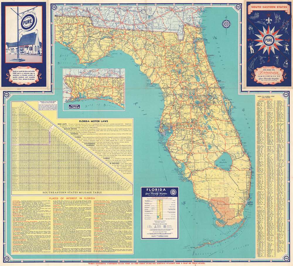
This is a c. 1940 Rand McNally and Pure Oil map of Florida. 'Main through routes', as they are referred to in the key, are illustrated by thick red lines, allowing the traveler or tourist in possession of this map to easily identify the best way to their destination. These were also known as interstate highways, which are different from today's interstates, which did not begin construction until 1956 under the auspices of President Dwight D. Eisenhower. State highways are illustrated by blue lines, with thinner lines marking roads of less dependable grades. Cities and towns throughout the state are labeled, and distances between them are provided as well. Points of interest, including state parks and many tourist attractions, are all labeled in red, allowing them stand out. An inset map of western Florida is situated in the Gulf of Mexico and a mileage table and short descriptions of places of interest in Florida occupy the lower right quadrant.
Dating the Map
As this map is undated, precisely dating the map is difficult. We believe that the presence of the old Florida State Road numbering system, which we noticed because the Overseas Highway is labeled here as Highway 4A, that this map dates from around 1940. Florida State Roads were renumbered in 1945. Marineland of Florida, situated along the coast between Saint Augustine and Daytona Beach, was a popular tourist attraction opened in Florida in 1938, and thus we have postdated the map slightly to account for its presence on the map.Publication History and Census
This map was created by Rand McNally and published by the Pure Oil Company c. 1940. We have been unable to locate any other examples.Cartographer
Rand, McNally and Co. (fl. 1856 - present) is an American publisher of maps, atlases and globes. The company was founded in 1856 when William H. Rand, a native of Quincy, Massachusetts, opened a print shop in Chicago. Rand hired the recent Irish immigrant Andrew McNally to assist in the shop giving him a wage of 9 USD per week. The duo landed several important contracts, including the Tribune's (later renamed the Chicago Tribune) printing operation. In 1872, Rand McNally produced its first map, a railroad guide, using a new cost effective printing technique known as wax process engraving. As Chicago developed as a railway hub, the Rand firm, now incorporated as Rand McNally, began producing a wide array of railroad maps and guides. Over time, the firm expanded into atlases, globes, educational material, and general literature. By embracing the wax engraving process, Rand McNally was able to dominate the map and atlas market, pushing more traditional American lithographic publishers like Colton, Johnson, and Mitchell out of business. Eventually Rand McNally opened an annex office in New York City headed by Caleb S. Hammond, whose name is today synonymous with maps and atlases, and who later started his own map company, C. S. Hammond & Co. Both firms remain in business. More by this mapmaker...
Condition
Very good. Light wear along original fold lines. Exhibits slight loss at fold intersections. Map of southeastern United States on verso.