1843 Malte-Brun Map of France in 1789
France1789-maltebrun-1843$100.00

Title
France en 1789.
1843 (undated) 9.5 x 12.5 in (24.13 x 31.75 cm)
1843 (undated) 9.5 x 12.5 in (24.13 x 31.75 cm)
Description
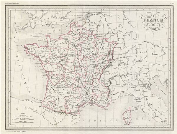
This is a fine example of Conrad Malte-Brun's 1843 map of France in 1789. Marking a period of historical significance, this map depicts the French empire before Napoleon's conquests. The color coding defines the designated borders of France in 1789. The French Revolution began in 1789 and resulted in the abolition of the French monarchy and its replacement with a radical democratic republic. In 1799, Napoleon Bonaparte staged a coup which led to Bonaparte's dictatorship and eventually (in 1804) his proclamation as emperor, which marked the end of the republican phase of the French Revolution. The 1812 French invasion of Russia marked a turning point in Napoleon's fortunes and led to the defeat of his forces at the ‘Battle of the Nations' in 1813. In 1814, a coalition of european powers defeated France and forced Napoleon into exile on the island of elba. Various cities, towns, rivers, islands and other topographical details are marked, with relief shown by hachure. This map was issued as plate no. 37 in Conrad Malte-Brun's 1843 Precis de la Geographie Universelle.
Cartographer
Conrad Malte-Brun (August 12, 1755 - December 14, 1826) was an important late 18th and early 19th century Danish / French cartographer and revolutionary. Conrad was born in Thisted, Denmark. His parents encouraged him to a career in the Church, but he instead enrolled in the University of Copenhagen. In the liberal hall of academia Conrad became an ardent supporter of of the French Revolution and the ideals of a free press. Despite the harsh censorship laws of crown prince Frederick VI, Malte-Brun published numerous pamphlets criticizing the Danish government. He was finally charged with defying censorship laws in 1799 and forced to flee to Sweden and ultimately France. Along with colleague Edme Mentelle, Malte-Brun published his first cartographic work, the Géographie mathématique, physique et politique de toutes les parties du monde (6 vols., published between 1803 and 1807). Conrad went on to found Les Annales des Voyages (in 1807) and Les Annales des Voyages, de la Géographie et de l'Histoire (in 1819). He also founded the Paris Société de Géographie . In time, Conrad Malte-Brun became known as one of the finest French cartographers of his time. His son Victor Adolphe Malte-Brun (1816 - July 13, 1889) followed in his footsteps, republishing many of Conrad's original 18th century maps as well as producing numerous maps of his own. The Malte-Brun firm operated well into the 1880s. More by this mapmaker...
Source
Malte-Brun, Precis de la Geographie Universelle, ou Description de Toutes les Parties du Monde sur un Plan Nouveau, d'après les Grandes Divisions Naturelles du Globe, (Paris) 1843.
Condition
Very good. Blank on verso.