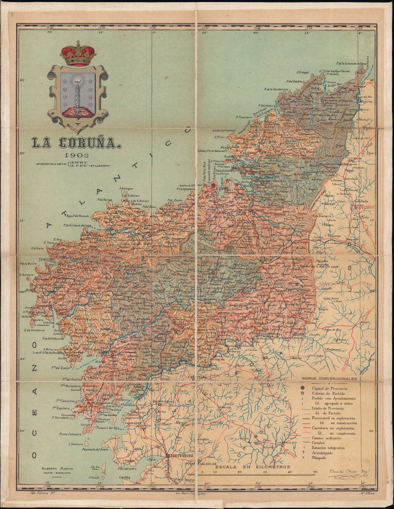
1903 Chias Folding Map of La Coruña, Galicia, Spain
Galicia-chias-1903$350.00


Title
La Coruña.
1903 (dated) 18.25 x 14.25 in (46.355 x 36.195 cm) 1 : 435000
1903 (dated) 18.25 x 14.25 in (46.355 x 36.195 cm) 1 : 435000
Description
An attractive 1903 separately-issued folding map of the province of La Coruña, consistent with the northwestern portion of the region of Galicia, in Spain. It was prepared by Benito Chías y Carbó and colleagues for their Atlas Geografico de España, but appears here as a separately-issued folding map.
The map is remarkably detailed, with towns and villages, roads (including highways, existing and under construction), railways (existing and under construction), canals, and the seats of bishops and archbishops. Aside from La Coruña, portions of the neighboring provinces of Pontevedra and Lugo are similarly detailed.
The Atlas Geografico de España occupies an ambiguous position set against these regional identity movements at the turn of the 20th century. On the one hand, by publishing an atlas of the regions together under the title chosen, it could be seen as promoting national unity. Notably, the standard Spanish pronunciation of the city and region (La Coruña) is used, instead of the current Galician rendering of A Coruña. On the other, by providing such detailed information on each region's geography, complete with its coat of arms, and by publishing separately-issued maps of the various regions, as was done here, the atlas could also have been utilized by federalists and separatists to foster a stronger local identity.
A Closer Look
Occupying the northwestern portion of the historic region of Galicia, La Coruña (or A Coruña) is also the northwesternmost portion of Spain. It is notable for containing the medieval cities of A Coruña, namesake for the province and home to the Tower of Hercules, the oldest extant lighthouse in the world, and Santiago de Compostela, home to many impressive religious structures and the endpoint of the famous pilgrimage route, the Camino de Santiago.The map is remarkably detailed, with towns and villages, roads (including highways, existing and under construction), railways (existing and under construction), canals, and the seats of bishops and archbishops. Aside from La Coruña, portions of the neighboring provinces of Pontevedra and Lugo are similarly detailed.
Historical Context
Though less well-known as other separatist movements in Spain, such as in Catalonia or the Basque Country, Galicia also maintained a strong regional identity throughout the modern period that occasionally veered into separatism. Like many other regions in Spain, Galicia maintained an uneasy autonomy within the Spanish kingdom during the early modern period. With the invasion of Spain by Napoleon's armies and their eventual defeat, the region formally proclaimed itself a sovereign kingdom, but Madrid was able to reassert control by the mid-19th century. Local nationalist movements were prominent throughout the 19th century, overlapping with liberalism, as with a failed coup in 1846 (the Solis Uprising) against Spain's heavy-handed national government. In the aftermath of the uprising, Galicians focused on fostering linguistic and cultural identity (the Rexurdimento, modelled on the Catalan Renaixença), producing several renowned writers, including Rosalía de Castro, a cultural icon for the region.The Atlas Geografico de España occupies an ambiguous position set against these regional identity movements at the turn of the 20th century. On the one hand, by publishing an atlas of the regions together under the title chosen, it could be seen as promoting national unity. Notably, the standard Spanish pronunciation of the city and region (La Coruña) is used, instead of the current Galician rendering of A Coruña. On the other, by providing such detailed information on each region's geography, complete with its coat of arms, and by publishing separately-issued maps of the various regions, as was done here, the atlas could also have been utilized by federalists and separatists to foster a stronger local identity.
Publication History and Census
This map was drawn by Joaquín Ribera y S. Poch, engraved by J. Mas, overseen by Benito Chías y Carbó, printed by Litografía Martí Campaña, and published by Alberto Martín in 1903 for the Atlas Geografico de España, which was one volume of a larger Atlas Geográfico Ibero-Americano. However, this example was dissected, laid on linen, and separately issued. We have been unable to locate any other examples of the map in this format in institutional collections or on the market.CartographerS
Benito Chías y Carbó (1864 - 1925) was a Spanish military engineer and cartographer. Chías y Carbó created numerous maps and atlases, the most renowned of which are part of the 'Regional Spain' series. Among his other most respected works are the Atlas Geográfico Pedagógico de España which included 240 maps, the Atlas Geográfico de Portugal, the Atlas Geográfico de México and the Atlas Geográfico Ibero-Americano. All of his works were published by the Editorial Alberto Martín. More by this mapmaker...
Alberto Martín (18xx - 1917) was a Spanish publisher in Barcelona in the late 19th and early 20th century. He founded the Editorial Alberto Martín, which specialized in publishing works of a geographical, folkloric, and touristic nature. His goal was to disseminate information about the art, archaeology, history, and geography of the Iberian Peninsula. Works published by the Editorial Alberto Martín were known for quality photographic illustrations. After Martín's death in 1917, his daughter Dolores Martín Zamora took over the publishing firm. Learn More...
Joaquín Ribera y S. Poch (fl. c. 1900 - 1905) was a Spanish artist and cartographer known for his work with Benito Chías y Carbó and Editorial Alberto Martín, especially their Atlas Geográfico Ibero-Americano. Learn More...
Litografía Martí Campaña (c. 1887 - 1905), sometimes as Litografía de M. Martí y Campañá, was a lithographic printer specializing in maps based in Barcelona. The firm frequently collaborated with Benito Chías y Carbó and Editorial Alberto Martín, as with their Atlas Geográfico Ibero-Americano. Learn More...
Condition
Excellent. Dissected and mounted on linen in 8 panels.