1835 Manuscript Map of the Gambier or Mangareva Islands in French Polynesia
GambierGroup-manuscript-1835$250.00

Title
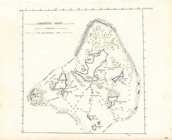
Gambier Group.
1835 (dated) 7.5 x 7.5 in (19.05 x 19.05 cm) 1 : 150000
1835 (dated) 7.5 x 7.5 in (19.05 x 19.05 cm) 1 : 150000
Description
This is an beautifully detailed 1835 manuscript map or nautical chart depicting the Gambier or Mangareva Islands in French Polynesia. Although identified by names given to the islands at the time, the map is centered on Mangareva (labeled Pearl Island), and includes other notable islands of the group. Beautifully detailed coastal features and numerous depth soundings are noted throughout.
Frederick William Beechey was a British naval officer, explorer, artist and hydrographer who was tasked to explore the Bering Strait in 1825 and attempt to make contact with either the overland expedition of Franklin from the Mackenzie River or the naval expedition from Prince Regent Inlet under Parry. While he was unable to rendezvous with either Franklin or Parry, his three year long voyage led him to discover several islands in the Pacific. He published an account of this expedition in the Narrative of a voyage to the Pacific and Beering’s Strait. This map is based on the surveys of Captain Beechey in 1826 and first appeared in his Narrative.
Frederick William Beechey was a British naval officer, explorer, artist and hydrographer who was tasked to explore the Bering Strait in 1825 and attempt to make contact with either the overland expedition of Franklin from the Mackenzie River or the naval expedition from Prince Regent Inlet under Parry. While he was unable to rendezvous with either Franklin or Parry, his three year long voyage led him to discover several islands in the Pacific. He published an account of this expedition in the Narrative of a voyage to the Pacific and Beering’s Strait. This map is based on the surveys of Captain Beechey in 1826 and first appeared in his Narrative.
Condition
Very good. Manuscript map. Minor spotting.