1890 Kartographisches Institut Map and Views of Lake Garda, Italy
Gardasee-kartographischesinstitut-1890$1,800.00

Title
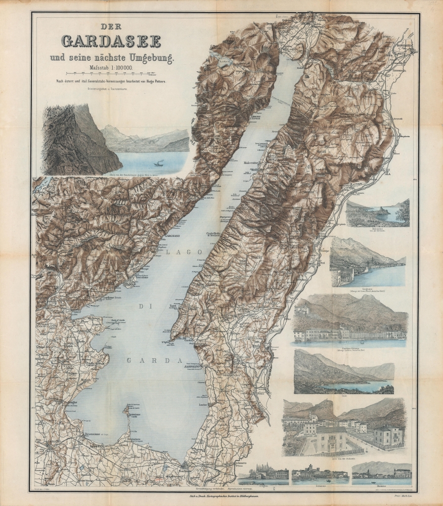
Der Gardasee und seine nächste Umgebung.
1890 (undated) 22.5 x 18 in (57.15 x 45.72 cm) 1 : 100000
1890 (undated) 22.5 x 18 in (57.15 x 45.72 cm) 1 : 100000
Description
A lovely c. 1890 map and set of views of Lake Garda, Italy, produced by the Kartographisches Institut, based in Hildburghausen. It was intended for German-speaking tourists, who were drawn to Guarda despite relatively recent fighting during the Italian Risorgimento, continued territorial divisions, and simmering tensions.
Lake Garda is the largest lake in Italy and one of its most popular tourist destinations. Sitting at the foot of the Dolomites about halfway between Milan and Venice, it offers similar benefits as the glacial lakes of far northern Italy and Switzerland at a more accessible location. The lake was the site of Roman villas for the empire's elite and at the time this map was made was a popular destination for wealthy tourists from throughout Italy and Europe. In the 20th century, the expansion of infrastructure made the lake's beautiful sights available to a wider range of social classes. For much of their history, small seaside towns crammed between mountains and the lake, such as Limone and Gardone Riviera, were only accessibly by boat or difficult mountain passes.
Despite their relative seclusion, the towns around the lake were the site of fighting during the Napoleonic Wars, the Italian Risorgimento, and the World War I. Though no international border is noted here, the northern portion of the lake, being part of Trentino, remained under Austrian control until the end of World War I. In the Interwar Period, the Italian nationalist poet Gabriele D'Annunzio settled near Garda, attracted both by its beauty and its importance to the nationalist cause (incidentally, the far-right dictator of Austria prior to the Anschluss with Germany, Kurt Schuschnigg, was born in Riva). During the Second World War, after the Allies captured Rome, the remnants of Mussolini's regime formed a new government (the Italian Social Republic) based at Salò on the west coast of the lake.
A Closer Look
The lake and its surroundings are included, with shading and hachures indicating elevation, which is also noted at various points (presumably in meters). No legend is provided, but roads, mountain passes, railways (including the Milan-Venice Line at bottom), rivers, and towns are indicated. Surrounding the map are views of famous sites and major towns around the lake, including the presence of German hoteliers at some. Latitude and longitude (on the Ferro Meridian) lines are inserted subtly in the margins.Lake Garda is the largest lake in Italy and one of its most popular tourist destinations. Sitting at the foot of the Dolomites about halfway between Milan and Venice, it offers similar benefits as the glacial lakes of far northern Italy and Switzerland at a more accessible location. The lake was the site of Roman villas for the empire's elite and at the time this map was made was a popular destination for wealthy tourists from throughout Italy and Europe. In the 20th century, the expansion of infrastructure made the lake's beautiful sights available to a wider range of social classes. For much of their history, small seaside towns crammed between mountains and the lake, such as Limone and Gardone Riviera, were only accessibly by boat or difficult mountain passes.
Despite their relative seclusion, the towns around the lake were the site of fighting during the Napoleonic Wars, the Italian Risorgimento, and the World War I. Though no international border is noted here, the northern portion of the lake, being part of Trentino, remained under Austrian control until the end of World War I. In the Interwar Period, the Italian nationalist poet Gabriele D'Annunzio settled near Garda, attracted both by its beauty and its importance to the nationalist cause (incidentally, the far-right dictator of Austria prior to the Anschluss with Germany, Kurt Schuschnigg, was born in Riva). During the Second World War, after the Allies captured Rome, the remnants of Mussolini's regime formed a new government (the Italian Social Republic) based at Salò on the west coast of the lake.
Publication History and Census
This map was produced by the Kartographisches Institut (von Hugo Petters) in Hildburghausen around 1890 or earlier (it does not include the Mori–Arco–Riva Railway, completed 1891). Not much information is available about this institution or its members, including the artists and engravers listed here, but it appears to have been active between about 1880 and 1910. This map is rare, only being listed among the holdings of the Staatsbibliothek zu Berlin and the Deutsche Nationalbibliothek Leipzig (a digital copy is also held by the Universität Wien, which may be a scan of a physical map held by the university), and it is scarce to the market.Condition
Very good. Some wear and discoloration along fold lines.
References
OCLC 1268272367.