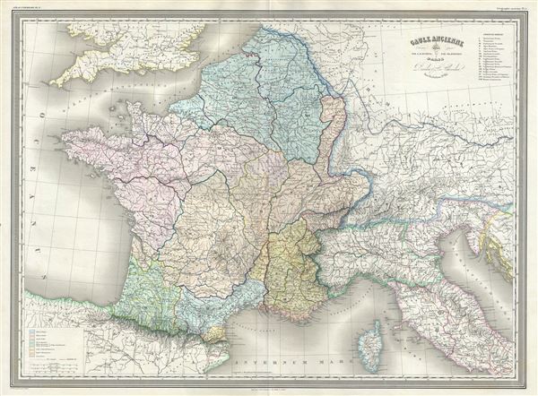
1860 Dufour Map of Gaul or France in Ancient Roman Times
GauleAncienne-dufour-1860$225.00

Title
Gaule Ancienne.
1860 (dated) 23 x 31 in (58.42 x 78.74 cm) 1 : 2315000
1860 (dated) 23 x 31 in (58.42 x 78.74 cm) 1 : 2315000
Description
This is a beautiful and scarce 1860 elephant folio map of Gaul or France in ancient Roman times issued by A. H. Dufour. It covers from the English Channel south as far as the Pyrenees Mountains and Hispania. It includes the modern day nations of France, Luxembourg, Belgium, Switzerland and the Netherlands. The map is beautifully color coded and numbered with a key in the upper right quadrant identifying the 17 provinces under the Roman Emperors.
Gaul was the ancient name of a region of Western Europe which comprises of modern day France, Luxembourg, Belgium and Germany west of the Rhine. It also included most of Switzerland, the western part of Northern Italy and parts of Netherland. After the Gallic Wars of 58-51 BC, all of Gaul came under the control of the Romans. It continued to remain under Roman control for almost 500 years before it fell to the Franks in AD 486. The Gallic Wars are believed to have been fought primarily to provide Caesar with wealth and popularity and to boost his political career rather than being a defensive action as described by Caesar. The campaigns are described by Caesar in his book Commentarii de Bello Gallico.
This map was prepared by Auguste-Henri Dufour and engraved by Charles Dyonette for publication plate no. 5 in Armand Le Chevalier's 1860 edition of Atlas Universel, Physique, Historique et Politique de Geographie Ancienne et Moderne.
CartographerS
Adolphe Hippolyte Dufour (1795 - 1865), also known as Auguste-Henri Dufour, was a Paris based map and atlas publisher active in the middle to late 19th century. Dufour claimed to be a student of another French cartographer, Emile Lapie. He is known to have worked with numerous other French cartographers, publishers, and engravers of the period including Andriveau-Goujon, Charles Dyonnet, and Duvotenay. His corpus includes numerous maps and atlases, the most striking of which is probably his monumental elephant folio Atlas Universel Physique, Historique et Politique Geographie Ancienne et Moderne. Dufour's student and successor was Alexandre Vuillemin. More by this mapmaker...
Charles Dyonnet (fl. c. 1822 - c. 1880) was an extremely active Paris based engraver working in the mid to late 19th century. From his offices at 220 Rue St. Jacques, Paris, Dyonnet engraved numerous maps for many of the most prominent 19th French cartographic publishers including Vuillemin, Dufour, Fremin and Duvotenay. From 1850-1861, he held the coveted position of "Graveur du Dépot de la Marine," and in this position engraved numerous French naval and military maps. Dyonnet had a detail oriented and aesthetically minded hand and is responsible from some of the most beautiful French maps to emerge during the 19th century. Learn More...
Source
Chevalier, A., Atlas Universel, Physique, Historique et Politique de Geographie Ancienne et Moderne, Paris 1860.
The 19th century French cartographer Auguste-Henri Dufour began publishing the dramatic elephant folio Atlas Universel, also occasionally titled Grand Atlas Universal, around 1855. Several editions appeared between its initial publication in the 1850s and a final run c. 1870. The 1863 and 1864 editions in particular are highly desirable among collectors because the United States and North America maps illustrate the proposed, but unrealized, state of Corona (roughly modern day Utah). The atlas contained roughly 40 maps, most of which were engraved by Louis Antoine (the maps) and Deletre (typography) under the supervision of Charles Dyonnet, official engraver of the Depot de la Marine. The Atlas Universal was published in Paris and edited by the firm of 'Paulin et le Chevalier,' 60 Rue Richelieu.
Condition
Very good. Minor wear along original fold lines. Minor spotting at places.
References
Rumsey 5020.008.