1846 Lowenberg Whimsical Map of Germany
Germany-lowenberg-1846$100.00

Title
Deutschland.
1846 (undated) 5.5 x 6.5 in (13.97 x 16.51 cm)
1846 (undated) 5.5 x 6.5 in (13.97 x 16.51 cm)
Description
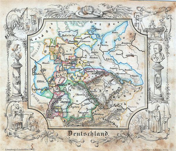
A delightfully whimsical 1846 map of Germany, from a German kinderatlas or children's atlas. The map details Germany from Holstein to Salzburg with divisions shown by color coding. The whole is surrounded by a wide border featuring charming vignettes meant to illustrate the peoples and cultures of the region. These include busts of two Germans, a bishop giving a sermon, a woman holding a candle with a man kneeling next to her, etc. The map is accompanied by its adjacent page, which includes a poetic history of Germany in German gothic type. The wonderful and rare map was drawn by Anst. V A. Boeden of Berlin for inclusion as plate no. VII in the 1846 issue of Julius Loewenberg's Geographische Landerfibel.
Cartographer
Julius Loewenberg (1800 - December 12, 1893) was a German Jewish printer, geographer, and author active in Berlin during the middle part of the 19th century. Loewenberg was born in the Duchy of Posen. He attended Yeshiva in Kleczewo (Poland) and graduated to the Protestant Gymnasium of Thorn before moving on to study Christian theology and geography at the Universtiy of Berlin. His works include various atlases, histories, and several translations of the works of Alexander von Humboldt, with whom he was apparently close. Loewenberg died in a Jewish retirement home in Berlin. More by this mapmaker...
Source
Lowenberg, J., Geographische Landerfibel, (Berlin: Stern & C.) 1846.
Condition
Average. Overall toning with foxing overall. Blank on verso.