Digital Image: 1835 Lauvergne / Himely View of Goree, Dakar, Senegal
Goree-lauvergne-1835_d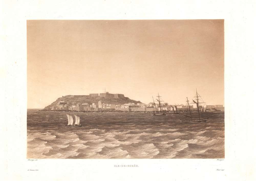

Title
Ile-de-Goree.
1835 (undated) 8.5 x 12.5 in (21.59 x 31.75 cm)
1835 (undated) 8.5 x 12.5 in (21.59 x 31.75 cm)
Description
FOR THE ORIGINAL ANTIQUE MAP, WITH HISTORICAL ANALYSIS, CLICK HERE.
Digital Map Information
Geographicus maintains an archive of high-resolution rare map scans. We scan our maps at 300 DPI or higher, with newer images being 600 DPI, (either TIFF or JPEG, depending on when the scan was done) which is most cases in suitable for enlargement and printing.
Delivery
Once you purchase our digital scan service, you will receive a download link via email - usually within seconds. Digital orders are delivered as ZIP files, an industry standard file compression protocol that any computer should be able to unpack. Some of our files are very large, and can take some time to download. Most files are saved into your computer's 'Downloads' folder. All delivery is electronic. No physical product is shipped.
Credit and Scope of Use
You can use your digial image any way you want! Our digital images are unrestricted by copyright and can be used, modified, and published freely. The textual description that accompanies the original antique map is not included in the sale of digital images and remains protected by copyright. That said, we put significant care and effort into scanning and editing these maps, and we’d appreciate a credit when possible. Should you wish to credit us, please use the following credit line:
Courtesy of Geographicus Rare Antique Maps (https://www.geographicus.com).
How Large Can I Print?
In general, at 300 DPI, you should at least be able to double the size of the actual image, more so with our 600 DPI images. So, if the original was 10 x 12 inches, you can print at 20 x 24 inches, without quality loss. If your display requirements can accommodate some loss in image quality, you can make it even larger. That being said, no quality of scan will allow you to blow up at 10 x 12 inch map to wall size without significant quality loss. For more information, it is best consult a printer or reprographics specialist.
Refunds
If the high resolution image you ordered is unavailable, we will fully refund your purchase. Otherwise, digital images scans are a service, not a tangible product, and cannot be returned or refunded once the download link is used.
Cartographer S
Barthélemy Lauvergne (July 4, 1805 - November 15, 1871) was a French painter, maritime, and landscape artist active throughout the middle years of the 19th century. Lauvergne was born in Tulon and mastered drawing under Pierre Letuaire (1798 - 1885). He was immediately drawn the exotic and began to travel son after reaching adulthood - circumnavigating the world three times. He first accompanied the French naval officer Jules Sébastien César Dumont d'Urville (1790 - 1842) onboard the L'Astrolabe (1826 - 1829), then Cyrille Pierre Théodore Laplace (1793 - 1875) on La Favorite (1830 - 1832), and finally Auguste-Nicolas Vaillant (1793 - 1858) La Bonite (1836 - 1837). He also participated as an artist on Arctic voyages to Iceland, Spitzbergen, Finland, and Norway. In February of 1841 he was appointed to the Dépôt des Cartes et Plans de la Marine, where with government sponsorship, he published hundreds of finely lithographed images from his voyages - creating unique visual record of cultural interactions between European explorers and indigenous peoples. He painted a portrait of Napoleon III in 1851. Lauvergne retired to his hometown, Toulon, in 1863, and died 8 years later in 1871. More by this mapmaker...
Sigismond Himely (June 7, 1801 - 1872) was a Swiss painter, viewmaker, acquaint engraver active in Paris during the middle part of the 19th century. Hinley was born in La Neuveville, Bern, Switzerland, but moved to Paris to study painting with Copley Fielding (1787 - 1855) and Jean-Victor Bertin (1775 - 1842). He exhibited in the Paris Salons between 1824 and 1869. He is known for his work engraving aquatints for English watercolorists and his names is associated with numerous historical views, city bird's-eye panoramas, architectural illustrations, and ethnographic images, among them rare illustrations of Asia, Africa, and the Americas. Learn More...
Louis Auguste de Sainson (April 26, 1800 – 1877) was a French artist, lithographer, and engraver. He worked as a draughtsman on the ship Astrolabe in its circumnavigation of the globe in 1826 – 1829, and then spent nearly five years preparing prints for the publication of the account of the expedition. Afterwards, he participated in the publication of prints about two other expeditions. Learn More...
Source
Voyage autour du monde par les mers de l'Inde et de la Chine de la corvette de sa Majeste 'La Favorite' execute pendant les annees 1830, 1831, 1832..., (Paris) 1835.
References
OCLC 221008405.