1956 Davis Pictorial Map of Guam
Guam-swigartdavis-1956$350.00

Title
Island of Guam. / pictorial and road map of Guam.
1956 (undated) 24.25 x 17.75 in (61.595 x 45.085 cm) 1 : 87000
1956 (undated) 24.25 x 17.75 in (61.595 x 45.085 cm) 1 : 87000
Description
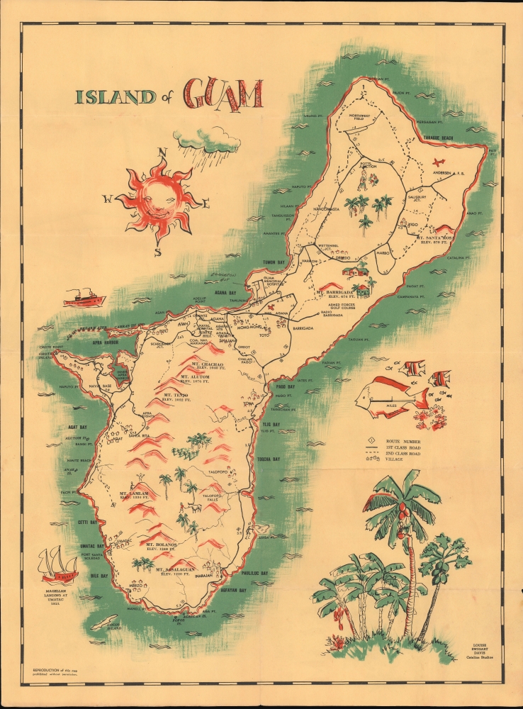
This is a c. 1956 Louise Swigart Davis pictorial folding map of Guam (Guåhan), produced for Catalina Studios.
A Closer Look
Depicting the entire island, a brilliant blue sea surrounds Guam. Red mountains hint at the island's topography and blue palm trees refer to its tropical climate. Guam, a U.S. territory in Micronesia in the western Pacific, is a major strategic asset for the U.S. military. The island hosts U.S. Navy and U.S. Air Force Bases. These bases are prominently labeled, including Naval Air Station Agana, the U.S. Naval Hospital, Naval Base Marianas, Headquarters Commander Naval Forces Marianas, Anderson Air Force Base, and Northwest Air Force Base. Towns and villages around the island are identified, along with golf courses, conservation reserves, individual mountain peaks, rivers, and other sites.Verso Content
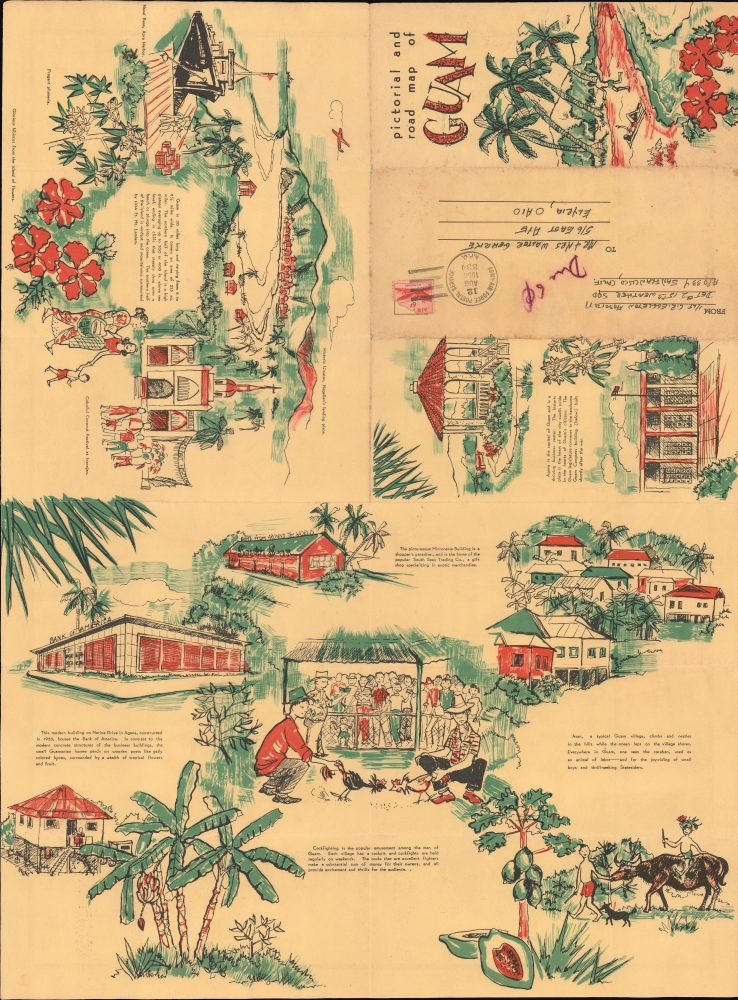
Wonderful brightly colored illustrations adorn the map's verso and highlight important sites and aspects of Guam's culture. There are short descriptions of a coconut festival Inarajan (Inalåhan), several depictions of Agana (Inalåhan), Guam's capital, and discussion of the island's physical characteristics. Perhaps the most intriguing part of this piece is that it was meant to be folded up and sent via the post, as is evidenced by the 'To' and 'From' fields on the verso. The present example was used for just that purpose. It is postmarked August 1956 and was sent to Elyria, Ohio from San Francisco.Historical Context
Guam was among the territories acquired by the United States of America in the wake of the Spanish-American War (1898). The island's proximity to Japan and strategic importance for the U.S. made it a target in the opening phase of the Pacific War during World War II. Japanese troops occupied the island in the hours and days after the attack on Pearl Harbor and instituted a brutal occupation, which, along with the 1944 battle in which the U.S. retook the island, may have killed one-tenth of the island's civilian population. After the war, the people of Guam were given a measure of autonomy (Guam Organic Act of 1950), which they had long advocated for, but a heavy U.S. military presence has remained, with nearly a dozen military bases and thousands of personnel at any given time, which has increased in recent years in tandem with U.S.-China tensions and as other bases (particularly on Okinawa) have been scaled back due to local opposition.Publication History and Census
This map was drawn by Louise Swigart Davis and printed by Catalina Studios c. 1956. It is uncatalogued in OCLC and we are aware of only one other example in private hands.Cartographer
Louise Swigart Davis (August 16, 1931 - February 10, 2022) was an artist, illustrator, and painter based in Kansas and Kansas City, Missouri. She attended Wyandotte High School in Kansas City and then earned an arts degree at the University of Kansas in 1953. While raising three children she also was deeply involved in local and regional arts organizations and exhibitions, and co-owned an arts supply store in Prairie Village, Kansas. Davis was an avid genealogist, a member of the Daughters of the American Revolution and the Mayflower Society. More by this mapmaker...
Condition
Good. Some wear along old fold lines, with slight loss at fold intersections. Promotional text on verso.