1780 Raynal and Bonne Map of Guyana and Surinam
Guyane-bonne-1780$150.00

Title
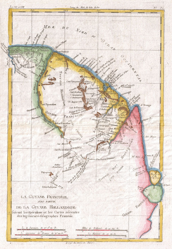
La Guyane Francoise Avec Partie De La Guyane Hollandoise
1780 (undated) 13 x 9 in (33.02 x 22.86 cm)
1780 (undated) 13 x 9 in (33.02 x 22.86 cm)
Description
A fine example of Rigobert Bonne and Guilleme Raynal's 1780 map of northeastern South America, depicting Guyana (Guyane). Covers parts of British Guyana, Dutch Surinam in the north, French Guyana (Guyane), modern day Mayapa, a Brazilian state, and Cap de Nord in the south. Most of the data for this map is drawn from records compiled under the Dutch West India Company, which traded throughout the region. While inland information is minimal, trading settlements and missions along both the Maroni River and the Tammouri are noted. Names numerous American Indian tribes and villages throughout. Additionally names Fort Oyapoque, modern day Oiapoque, and major cities, such as Paramibo, the present day capital of Suriname. Drawn by R. Bonne for G. Raynal's Atlas de Toutes les Parties Connues du Globe Terrestre, Dressé pour l'Histoire Philosophique et Politique des Établissemens et du Commerce des Européens dans les Deux Indes.
Cartographer
Rigobert Bonne (October 6, 1727 - September 2, 1794) was one of the most important French cartographers of the late 18th century. Bonne was born in Ardennes à Raucourt, France. He taught himself mathematics and by eighteen was a working engineer. During the War of the Austrian Succession (1740 - 1748) he served as a military engineer at Berg-op-Zoom. It the subsequent years Bonne became one of the most respected masters of mathematics, physics, and geography in Paris. In 1773, Bonne succeeded Jacques-Nicolas Bellin as Royal Cartographer to France in the office of the Hydrographer at the Depôt de la Marine. Working in his official capacity, Bonne compiled some of the most detailed and accurate maps of the period - most on an equal-area projection known erroneously as the 'Bonne Projection.' Bonne's work represents an important step in the evolution of the cartographic ideology away from the decorative work of the 17th and early 18th century towards a more scientific and practical aesthetic. While mostly focusing on coastal regions, the work of Bonne is highly regarded for its detail, historical importance, and overall aesthetic appeal. Bonne died of edema in 1794, but his son Charles-Marie Rigobert Bonne continued to publish his work well after his death. More by this mapmaker...
Source
Raynal, G., Atlas de Toutes les Parties Connues du Globe Terrestre, Dressé pour l'Histoire Philosophique et Politique des Établissemens et du Commerce des Européens dans les Deux Indes, 1780.
Condition
Very good. Original centerfold. Platemark visible. Blank on verso.