Digital Image: 1927 Muller Map of the Hai River, Tianjin (Tiantsin), China
HaiHoRiver-muller-1927_d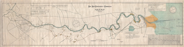

Title
Hai Ho Conservancy Commission. Plan of Hai-Ho from Tientsin City to the Sea. January 1927.
1927 (dated) 23 x 90 in (58.42 x 228.6 cm) 1 : 30000
1927 (dated) 23 x 90 in (58.42 x 228.6 cm) 1 : 30000
Description
FOR THE ORIGINAL ANTIQUE MAP, WITH HISTORICAL ANALYSIS, CLICK HERE.
Digital Map Information
Geographicus maintains an archive of high-resolution rare map scans. We scan our maps at 300 DPI or higher, with newer images being 600 DPI, (either TIFF or JPEG, depending on when the scan was done) which is most cases in suitable for enlargement and printing.
Delivery
Once you purchase our digital scan service, you will receive a download link via email - usually within seconds. Digital orders are delivered as ZIP files, an industry standard file compression protocol that any computer should be able to unpack. Some of our files are very large, and can take some time to download. Most files are saved into your computer's 'Downloads' folder. All delivery is electronic. No physical product is shipped.
Credit and Scope of Use
You can use your digial image any way you want! Our digital images are unrestricted by copyright and can be used, modified, and published freely. The textual description that accompanies the original antique map is not included in the sale of digital images and remains protected by copyright. That said, we put significant care and effort into scanning and editing these maps, and we’d appreciate a credit when possible. Should you wish to credit us, please use the following credit line:
Courtesy of Geographicus Rare Antique Maps (https://www.geographicus.com).
How Large Can I Print?
In general, at 300 DPI, you should at least be able to double the size of the actual image, more so with our 600 DPI images. So, if the original was 10 x 12 inches, you can print at 20 x 24 inches, without quality loss. If your display requirements can accommodate some loss in image quality, you can make it even larger. That being said, no quality of scan will allow you to blow up at 10 x 12 inch map to wall size without significant quality loss. For more information, it is best consult a printer or reprographics specialist.
Refunds
If the high resolution image you ordered is unavailable, we will fully refund your purchase. Otherwise, digital images scans are a service, not a tangible product, and cannot be returned or refunded once the download link is used.
Cartographer
Commercial Press (1897 – Present) (商务印书馆) is a publisher active in China from the late 19th century to present. It is considered to be China's first modern publisher, and was the largest publishing house in modern China, at the forefront of educational, scholarly, and literary development from 1900 to the 1950s. The Shanghai based press was founded in 1897 by Xia Ruifang who received venture capital from a Japanese firm. The firm immediately started amassing a collection of rare books which it republished using modern presses. It also introduced numerous periodicals ranging form the Eastern Miscellany (東方雜誌) to Youth Magazine (少年雜誌). It proved quite successful and, in 1914, Xia Ruifang attempted to buy out his Japanese investors. This resulted in his assassination shortly afterward. Nonetheless the press became a wholly Chinese organization under the reformer Zhang Yuanji (Yüan-chi Chang; 張元濟; 1867 - 1959), who succeeded Xia Ruifang in running the press. During World War II, during the January 28th Incident, the press and its collection of rare books was destroyed by Japanese bombers. Even so, by this time the press had expanded to multiple offices, including branches in Singapore, and was able to continue operating. During the Cultural Revolution (1966 - 1976), the Commercial Press was relocated to Beijing, and ceased all mapping operations. The press remains in operation today and has become a large international concern focused on the publication of Academic works. They now publish under the imprint Commercial Press International Limited. More by this mapmaker...
References
OCLC 261183715. Library of Congress, Map Department, G7822.H31 1921 .M8. Wang, Ai, City of the River: The Hai River and the Construction of Tianjin, 1897 – 1948, (Washington State University), August 2014.