1953 Mirabal Pictorial Map of Havana, Cuba
Havana2-mirabal-1953$450.00
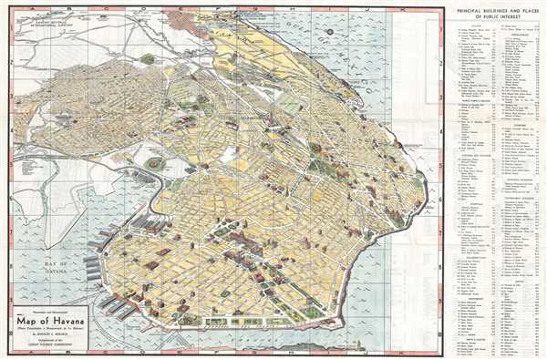

Title
Panoramic and Monumental Map of Havana. (Plano Panoramico y Monumental de La Habana).
1953 (dated) 20.5 x 31.25 in (52.07 x 79.375 cm)
1953 (dated) 20.5 x 31.25 in (52.07 x 79.375 cm)
Description
This is a 1953 Rogelio L. Mirabal panoramic map of Havana, Cuba issued by the Cuban Tourist Commission, capturing the city at the height of its romantic literary period in the early fifties. The map depicts the city from Havana Bay to the Gulf of Mexico and from Rancho Boyeros International Airport to the Canal de Entrada. The Morro Castle, a fortress built at the entrance to Havana Bay, is partially illustrated in the lower right corner. Numerous buildings, monuments, and other locations throughout the city are depicted in profile, some of which, including the National Capitol building, police headquarters, Atares Castle, and Punta Castle, are identified by name. Other locations illustrated in this way are labeled numerically, and these numbers that correspond with a key situated along the map's right border, which also provides each site's grid location on the map. Neighborhoods throughout the city are labeled, as are major streets. An alphabetic street index is included along the left border. Piers along Havana's harbor are also illustrated and labeled, as are the routes of launches to Regla, Casa Blanca, and La Cabaña Fortress.
Paris of the Caribbean
This map depicts Havana during the period that lured not only capital, but western artists and writers to the hard-playing city. The map reflects Havana as it was known to Graham Greene, who was convinced during his early-fifties visits there to choose it as the setting for his cold war farce (Our Man in Havana had initially been set in Estonia!) The map illustrates some of the key locations in Greene's book: The Vedado's beautiful Hotel Nacional, Hotel Inglaterra, and Hotel Sevilla are shown pictorially and named in the map's legend. Also pictured is Ernest Hemingway's longtime Havana hotel, Ambos Mundos, conveniently down Obispo street from his favored bar, Floridita, where he set the house record for drinking sixteen double daquiris at a sitting.Publication History and Census
This map was drawn by Rogelio L. Mirabal and issued by the Cuban Tourist Commission in Havana in 1953. The map is well represented in institutional collections.Condition
Very good. Light toning. Light wear along original fold lines. Text and map of Marianao on verso.
References
OCLC 18380030.