1960 Aloha Airlines Pictorial Route Map of the Hawaiian Islands
Hawaii-alohaairlines-1960$400.00

Title
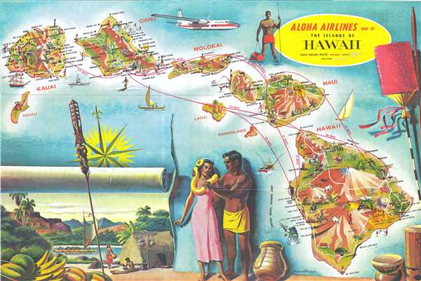
Aloha Airlines Map of the Islands of Hawaii.
1960 (undated) 12 x 18 in (30.48 x 45.72 cm) 1 : 1280000
1960 (undated) 12 x 18 in (30.48 x 45.72 cm) 1 : 1280000
Description
This is a c. 1960 Aloha Airlines route map of the Hawaiian Islands. The map depicts seven of the main islands in the archipelago, including Hawaii, Maui, Lanai, Molokai, Oahu, Kauai, and Niihau. Of these seven, Lanai and Niihau are the least illustrated, bearing only one small vignette each and no labeled locations. Each of the other five, however, are highly detailed and richly illustrated. Numerous locations on each island are labeled, including cities, towns, points, swimming beaches, and other sites. Mauna Loa and Mauna Kea are both labeled on Hawaii, along with Hawaii Volcanoes National Park, and the cities of Hilo and Hawi. Haleakala National Park is illustrated on Maui, while Honolulu, Pearl Harbor, Waikiki Beach, and Diamond Head are labeled on Oahu. Each island bears illustrations of both livestock and wildlife, as well as lighthouses and airports (a major point of interest for an airline). Routes between these airports are illustrated in red, some of which stretch between the islands, while others simply connect two different airports on the same island (between Kona airport and Upolu airport on Hawaii). Each route's distance is included along the line, giving the viewer an idea of how far it is between the islands. Several large vignettes of life on the islands surround the archipelago, including a spearfisherman, what appears to be a scene of traditional island life, and various island artifacts. A Fairchild F-27 turboprop aircraft is illustrated along the top border.
This map was created by Lonn Allison and published by Aloha Airlines c. 1960. Although undated, we are able to date this map by the presence of the Fairchild F-27. A cutting-edge aircraft at the time, Aloha Airlines took delivery of their first Fairchild F-27 on April 15, 1959, meaning that this brochure must post-date that delivery. This appears to be a relatively scarce piece, as we have been able to locate only one other example of this map bearing the illustration of the Fairchild F-27.
This map was created by Lonn Allison and published by Aloha Airlines c. 1960. Although undated, we are able to date this map by the presence of the Fairchild F-27. A cutting-edge aircraft at the time, Aloha Airlines took delivery of their first Fairchild F-27 on April 15, 1959, meaning that this brochure must post-date that delivery. This appears to be a relatively scarce piece, as we have been able to locate only one other example of this map bearing the illustration of the Fairchild F-27.
Condition
Very good. Even overall toning. Text on verso.