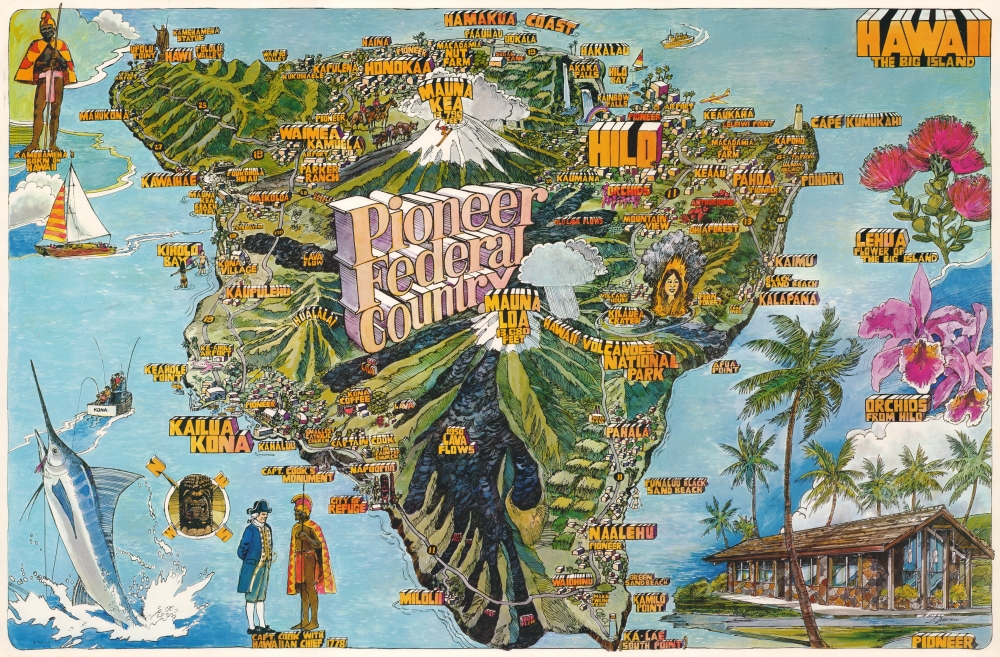
1976 Dawson Pictorial Map of the Big Island of Hawaii
HawaiiPioneerFed-dawson-1976$700.00


Title
Hawaii The Big Island. Pioneer Federal Country.
1976 (dated) 23 x 34.5 in (58.42 x 87.63 cm)
1976 (dated) 23 x 34.5 in (58.42 x 87.63 cm)
Description
This is a 1976 J. Dawson pictorial map of the Big Island of Hawaii. Dawson utilizes the Fillmore design, pioneered by promoters of The Fillmore, a legendary 1960s-70s San Francisco music venue. This map is one of a series commissioned by Pioneer Federal Savings and Loan, with 2 others created by Dawson and one by renowned artist Darrel Millsap.
A Closer Look
Hawaii fills the sheet, with cities, towns, and sites of interest labeled in the distinctive Fillmore style. Mauna Kea and Mauna Loa immediately draw the viewer's attention with their snowcapped peaks and over 13,000-foot elevations. Lava Flows appear on Mauna Loa's slopes and are identified by the eruption year. Kilauea and Hawaii Volcanoes National Park are to the right of Mauna Loa. Other sites of interest include the southernmost point in the United States, Rainbow Falls, the Puukohola Heiau, the City of Refuge, Captain Cook's Monument, and the Ohia Forest. Illustrations of lehua and orchids appear along the right border. An illustration of Captain Cook meeting a Hawaiian Chief is included along the bottom border next to a gigantic marlin being reeled in by a sport fisherman. A full-body portrait of King Kamehameha occupies the upper right corner.Fillmore style graphic design
Published in 1976, Dawson borrows some elements for this map of Kauai from the iconic concert posters created for The Fillmore, the legendary San Francisco music venue. The Fillmore posters' psychedelic styling and innovative typography cemented their place in popular culture. Dawson borrows this style from Darrel Millsap (1931 - 2012), an American artist based in California who utilized the Fillmore style for several maps of California published in the early 1970s, a map of Oahu and a map of Milwaukee and southeastern Wisconsin.Publication History and Census
This map was drawn by J. Dawson and published by Pioneer Federal Savings and Loan in 1976. It does not appear in OCLC, and we have not located any examples in institutional collections. We have not found another instance it on the private market.Condition
Excellent.