This item has been sold, but you can get on the Waitlist to be notified if another example becomes available, or purchase a digital scan.
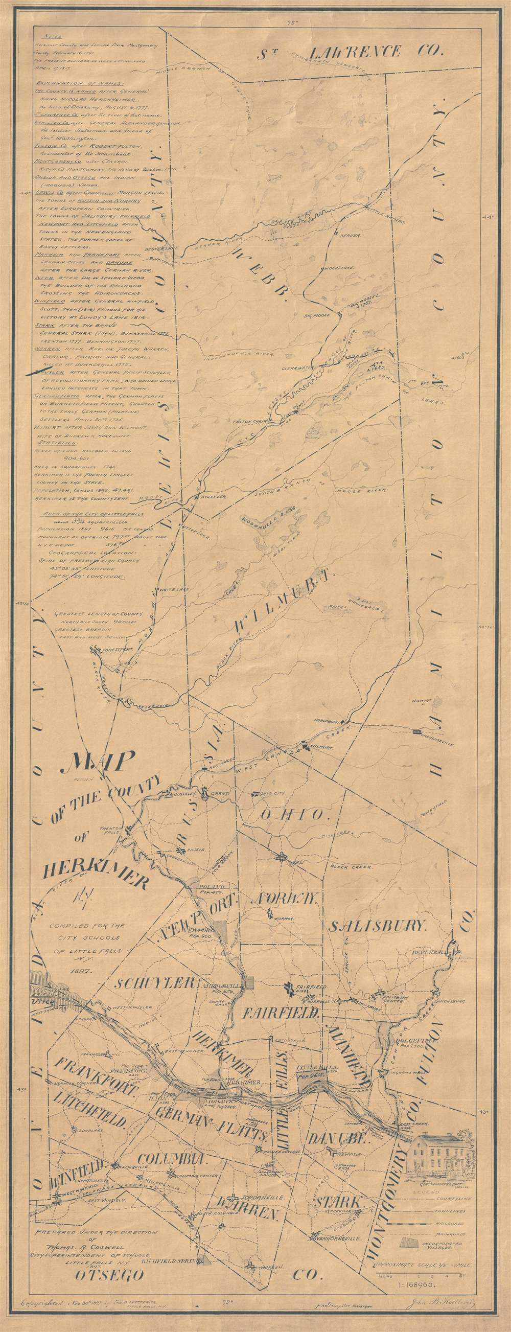
1897 Koetteritz Map of Herkimer County, New York
HerkimerCounty-koetteritz-1897$100.00

Title
Map of the County of Herkimer N.Y. Compiled for the city schools of Little Falls N.Y. 1897.
1897 (dated) 36 x 14 in (91.44 x 35.56 cm) 1 : 168960
1897 (dated) 36 x 14 in (91.44 x 35.56 cm) 1 : 168960
Description
This 1897 diazo print map of Herkimer County, New York presents the county with surveyor's precision. The map shows the entire county and labels the bordering counties: Otsego County in the south, Oneida County and Lewis County to the west, St. Lawrence County to the north, and Montgomery County, Fulton County, and Hamilton County to the east.
On the Map
The map was prepared under the direction of Thomas A. Caswell, the City Superintendent of Schools in Little Falls, N.Y, in 1897. Towns are labeled with their population. The largest of these is Little Falls, with a population of 9,615. The main roads and railroads are shown. The Erie Canal runs through Herkimer and its route from Utica, through Little Falls, and into Montgomery County is apparent. There is an explanation of the names on the map at the upper-left corner, including that the county is named after General Hans Nicolas Herckheimer, the hero of Oriskany, August 6, 1777. A lovely drawing of General Herkimer's Benton home is included on the right. Some statistics are also given about Herkimer County, stating that the area in square miles is 1,745 and that Herkimer is the fourth largest county in the state.Diazo Print or Whiteprint
The diazo print (whiteprint or diazo for short) is a photo reproductive technique best understood as a reverse cyanotype or blueprint. The process yields distinctive blue lines on white paper. Like cyanotypes, the diazo process gained popularity in architecture circles, where it was a simple and effective way to duplicate documents in the field. The earliest diazotypes appeared around 1880 and were adopted for military and field cartographic use from about 1895. The diazo process was commercialized in 1923, when the German firm, Kalle and Company, developed Ozalid, a patented diazo paper that made diazotyping even easier. By the 1950s, it supplemented cyanotypes as the reprographic technique of choice for technical drawings.Publication History and Census
We could find no known examples of this map and it would make a fine addition to anyone's collection, particularly those interested in New York geography, the Erie Canal, maps as educational materials, and New York railroad lines.Condition
Very good. Backed on linen.