1949 Love Pictorial Historical Map of Colorado
HistoricalColorado-love-1949$350.00
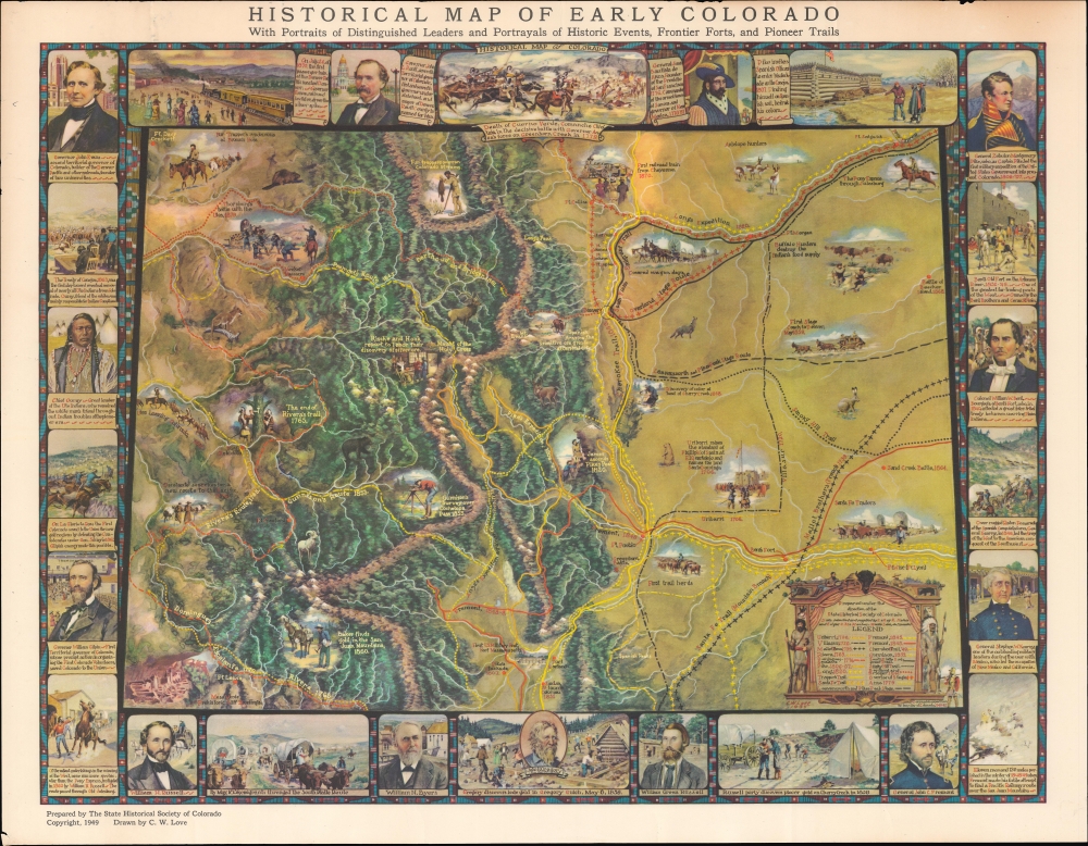

Title
Historical map of early Colorado : with portraits of distinguished leaders and portrayals of historical events, frontier forts, and pioneer trails.
1949 (dated) 19 x 24 in (48.26 x 60.96 cm)
1949 (dated) 19 x 24 in (48.26 x 60.96 cm)
Description
An informative and visually impressive 1949 map of Colorado, discussing its history from the arrival of the Spanish until the 1870s, mostly preceding statehood. The map was drawn by C. W. Love and prepared by the State Historical Society of Colorado.
A legend at bottom right explains the numerous trails and paths traced on the map, which also points out the sites of important events in the area's history, such as the discovery of gold and the geological surveys of John Williams Gunnison, a member of the Stansbury Expedition who conducted some of the earliest surveys of the future state. Several conflicts and violent incidents are discussed, including battles between native peoples and Spanish or American settlers, the Mexican-American War, and the U.S. Civil War.
A Closer Look
Covering territory consistent with the ultimate state of Colorado, this historical map delineates historical events beginning with the Spanish Era and the deeds of Governor and General Juan Bautista de Anza, who governed the Spanish province of New Mexico from 1778 until his death in 1788. Zebulon Pike, namesake for Pikes Peak, and other early 'Anglo' settlers, including the earliest governors of the Colorado Territory, also make an appearance. Other important figures and groups are discussed in some detail, including Ute Chief Ouray, the Pony Express, John C. Frémont, and Stephen W. Kearney.A legend at bottom right explains the numerous trails and paths traced on the map, which also points out the sites of important events in the area's history, such as the discovery of gold and the geological surveys of John Williams Gunnison, a member of the Stansbury Expedition who conducted some of the earliest surveys of the future state. Several conflicts and violent incidents are discussed, including battles between native peoples and Spanish or American settlers, the Mexican-American War, and the U.S. Civil War.
Commemorating Early Pioneers
This map fits within the genre of commemoration maps that appeared in the early-mid 20th century, produced by local historical societies and founders or pioneer associations in the American West. In publishing these historical maps, descendants of early Anglo pioneer settlers lionized their ancestors, often glossing over some of their unsavory actions in the process. This map is somewhat unusual in so overtly mentioning the removal of the Ute from the region, though it does laud Ouray for being a 'friend of the whites' who secured Ute 'compliance' with this involuntary arrangement.Publication History and Census
This pictorial map was drawn by C. W. Love and prepared by the State Historical Society of Colorado. Love's signature is dated 1935, but it was not published until 1949, suggesting that the original was a one-off piece, perhaps made for the Colorado Historical Society, that was later published for a wider audience. The map is listed among the holdings of about twenty institutions in OCLC, though its exact distribution is difficult to know for certain given inconsistencies in cataloging.Condition
Good. Some edge wear, especially at top and bottom-left.
References
OCLC 1984862, 5501960.