1928 Godwin Pictorial Map of Hollywood and Environs
Hollywood-godwin-1928$5,000.00

Title
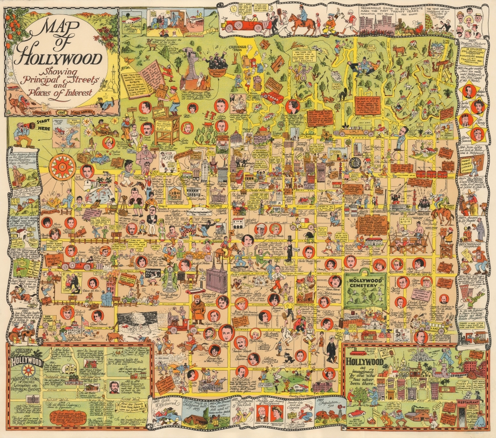
Map of Hollywood Showing Principal Streets and Places of Interest.
1928 (dated) 24 x 27 in (60.96 x 68.58 cm)
1928 (dated) 24 x 27 in (60.96 x 68.58 cm)
Description
This is Harrison Godwin's 1928 pictorial map of Hollywood, California, the rarest of his creations and a masterpiece of pictorial cartography. It provides a colorful, raucous, and molecularly local snapshot of the film industry near the end of the Silent Film Era and the advent of the 'Golden Age of Hollywood.'
Perhaps unbeknownst to Godwin, he captured Hollywood when it was on the brink of a major transformation. In 1927, the first full-length feature film with significant sound portions (mostly songs), The Jazz Singer, was released, which in retrospect was seen as the end of the Silent Film Era and the beginning of 'talkies' and the Golden Age of Hollywood, lasting into the 1960s. By the mid-1930s, nearly all big Hollywood productions adopted sound (using Vitaphone technology). Further changes were brought on by the Great Depression and the institution of the moralistic Hays Code, which restricted the crowd-pleasing but 'undignified' themes of many films of the Roaring Twenties. Most actors and some studios had difficulty adjusting to the era of 'talkies,' though Chaplin, fellow funnyman Buster Keaton, Greta Garbo, and a handful of other Silent Era stars managed to transition into the sound era successfully.
A Closer Look
Coverage ranges from the Hollywood Hills and Griffith Park in the north to Beverly Boulevard in the south and from Fairfax Avenue in the west to Western Avenue in the east. Local landmarks are labeled throughout, including the Hollywood Bowl, Hollywood (Forever) Cemetery, the Wilshire Country Club, and several film studios, as well as hotels, churches, temples, and schools. Some locations that have become staples of the Hollywood landscape were still relatively recent when this map was drawn, such as Grauman's Chinese Theater (opened only the preceding year). Throughout are portraits, caricatures, and references to the major movie stars, directors, and studios of the day, including Charlie Chaplain, Lon Cheney, Tom Mix, D. W. Griffith, Joan Crawford, Lillian Gish, Cecil de Mille, Will Rogers, Greta Garbo, and the recently-deceased Rudolph Valentino. Numerous illustrations make light of the heady atmosphere of the contemporary film industry and life in Hollywood. The border of the map consists of a series of illustrations in the style of a film reel that discuss the history of Hollywood and its current status, focusing on the film industry. (Additional historical tidbits appear on placards throughout the map itself.) At the bottom-left is an inset historical 'Chart of Hollywood', and at the bottom-right is a humorous map of 'Hollywood as imagined by one who has never been there.'The End of the Silent Era
As several notes on the map itself make clear, Hollywood grew very rapidly, from little more than a farming village in 1900 to a city of 140,000 by 1927, with the population more than doubling between 1921 and 1927. (Hollywood voted to join Los Angeles in 1910.) After some early forays by pioneers in the film industry, studios began to be constructed in rapid succession in the 1910s, drawn to Los Angeles by the ease of avoiding lawsuits at the hands of the Thomas Edison-led New Jersey-based Motion Picture Patents Company and to Hollywood specifically by the cheap and abundant land, good weather, and variety of settings (beach, mountains, city, countryside) close at hand. By the 1920s, the booming film industry had become the most profitable in California and the country. The figure of the film star was born, along with associated professions like paparazzi, gossip columnists, and organizers of celebrity tourism.Perhaps unbeknownst to Godwin, he captured Hollywood when it was on the brink of a major transformation. In 1927, the first full-length feature film with significant sound portions (mostly songs), The Jazz Singer, was released, which in retrospect was seen as the end of the Silent Film Era and the beginning of 'talkies' and the Golden Age of Hollywood, lasting into the 1960s. By the mid-1930s, nearly all big Hollywood productions adopted sound (using Vitaphone technology). Further changes were brought on by the Great Depression and the institution of the moralistic Hays Code, which restricted the crowd-pleasing but 'undignified' themes of many films of the Roaring Twenties. Most actors and some studios had difficulty adjusting to the era of 'talkies,' though Chaplin, fellow funnyman Buster Keaton, Greta Garbo, and a handful of other Silent Era stars managed to transition into the sound era successfully.
Provenance
This example of the map has an informal province linking it directly to Godwin. It is one of several maps given by Godwin to a friend and neighbor.Publication History and Census
This map was prepared by Harrison Godwin in 1928 and published by his brother, Fred Godwin, for the Hollywood Athletic Club. Of the three maps Godwin produced (the other being of San Francisco and North America), this is the rarest. No examples are noted in the OCLC, and the only institutional holding is with the David Rumsey Historical Map Collection. The map has only come to market once in recent years.CartographerS
William Harrison Godwin (March 21, 1899 - January 11, 1984), who went by Harrison, was an American cartoonist, pictorial map artist, and hotelier active in California during the early to middle parts of the 20th century. Harrison was born in Hackettstown, New Jersey. Harrison was a cartoonist with the Los Angeles Examiner and published two daily strips. With regard to cartographic material he published just three maps, San Francisco, Hollywood, and North America, all between the years of 1927 and 1929. The San Francisco and Hollywood maps were the first and second maps in a planned series of American cities, each taking some three months to complete. Curiously, no further maps in the series materialized. In addition to his cartoon work Harrison, in partnership with his brother Fred, owned Carmel-by-the-Sea's La Playa Hotel, where Harrison worked as a manager. Later, in 1940, Harrison sold his interest in the La Playa and acquired full ownership of the Pine Inn, also in Carmel and still active. Harrison and Fred Godwin and are credited with popularizing Carmel as a tourist destination. Little else is known of his life. More by this mapmaker...
Max Heinrich William Schmidt (February 17, 1850 - May 22, 1936) was a German-American engraver, lithographer, and publisher. Born in Schaemhaum, Germany, Schmidt left home at 14 when he chose to go to sea as a cabin boy instead of pursuing a career in medicine, as was family tradition. He spent the next 7 years traveling the world and developed his artistic skills aboard ship, keeping a meticulously lettered logbook. He arrived in San Francisco in 1871 and left his ship. First finding work in a restaurant, Schmidt soon began working for San Francisco lithographers, and spent the next three years working for Korbell Brothers, Grafton, T. Brown (San Francisco's only African American lithographer), and other San Francisco firms and engravers. He set up his own shop in 1874, called Schmidt and Buehler, in partnership with Frederick Buehler. They made pictorial cuts for local newspapers. Schmidt was on his own two years later, working under the name M. Schmidt and Company and producing stock certificates and colored lithographic labels. Schmidt incorporated the firm in 1883 under the name Schmidt Label and Lithographic Company. His factory burned in 1884 and again in 1886. In 1899, Schmidt acquired the lithographic firm Dickman-Jones and H.S. Crocker's label department and formed a new firm called the Mutual Label Company and Lithographic Company. In the early 1900s, Schmidt expanded to Los Angeles, when the Los Angeles Lithographic Company and the Western Lithograph Company became associated with Mutual. In 1906, the Great San Francisco Earthquake and Fire destroyed his company. He soon rebuilt and named the new firm the Schmidt Lithograph Company. Under this imprint, he printed all of Harrison Godwin's (1899 - 1984) famous pictorial maps. Schmidt continued to find success, and eventually expanded to Southern California, Texas, Utah, the Pacific Northwest, Florida, and Honolulu, making labels for producers and packers in all these areas. Although the firm did produce posters, booklets, and other forms of commercial lithography, it mainly focused on labels. The Stecher-Traung Company bought Schmidt Lithograph in 1966 and formed Stecher-Truang-Schmidt, which operated until 1994. Learn More...
Condition
Fine. Rich original chromolithograph color.
References
Rumsey 10004.000.