This item has been sold, but you can get on the Waitlist to be notified if another example becomes available, or purchase a digital scan.
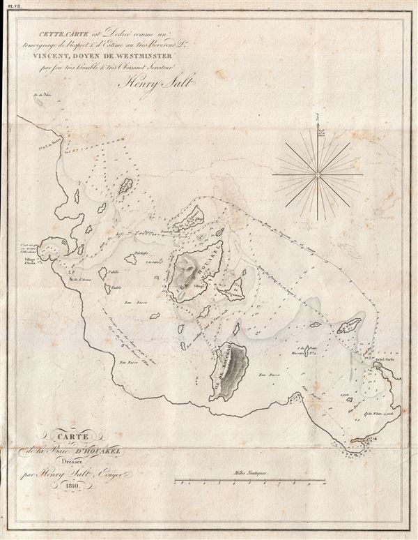
1810 Henry Salt Map of Howakil Island, Red Sea, Eritrea
Houakel-salt-1810$137.50

Title
Carte de la Baie D'Houakel.
1810 (dated) 15 x 12 in (38.1 x 30.48 cm) 1 : 171560
1810 (dated) 15 x 12 in (38.1 x 30.48 cm) 1 : 171560
Description
A scarce and important 1809 Henry Salt nautical chart or maritime map Howakil Bay (Houakel), Eritrea. Howakil Bay is a large bite in the coast of Eritrea. It is a maze of small islands, reefs, and shoals that even in the early 20th were imperfectly mapped. In the periploi of antiquity Howakil Bay was known as Opsian Bay. Salt came to this bay to search out the opsian stone, most likely a form of obsidian, for which the bay was famous in antiquity. Near the village of Arena, identified on the western shore of this map, Salt collected several opsian shards which were later proven to be obsidian. This map was drawn by Henry Salt and Captain Thomas Weatherhead. It is dedicated to William Vincent, a scholar of antiquities who translated The Periplus of the Erythrean Sea, and whose work guided Salt as he explored the Red Sea. Without having ever visited the region, it was Vincent who correctly identified Howakil Bay as the Opsian Bay of antiquity. The present example was prepared to illustrate the 1816 French edition of Salt's Voyage to Abyssinia.
Cartographer
Henry Salt (June 14, 1780 - October 30, 1827) was a British artist, traveler, diplomat, and Egyptologist active in the first decades of the 19th century. Salt was trained as an artist and traveled extensively in Asia as secretary and draughtsman to George Annesley, the Veiscount Valentia. His first expedition, which lasted from about 1802 to 1806 involved travels to Cape Colony, the east coast of Africa, the Ethiopian Highlands, and India. His paintings from the expedition were published in Annelsey's 1809 Voyages and Travels to India. Afterwards Salt returned to Africa on a government sponsored mission to Ethiopia in the hopes of establishing diplomatic and trade relationships with the Tigrayan warlord Ras Wolde-Sillasie. Salt published the narrative of this expedition in his 1814 book A Voyage to Abyssinia, which also featured a collection of important maps. Today Salt is best known as an Egyptologist and collector of antiquities. In 1815 he was appointed British Consul-General in Cairo, where he dedicated himself to building a vast collection of Egyptian antiquities. Around this time, the ancient monuments and tombs of Egypt were a free-for-all for enterprising Europeans with a penchant for antiquities. Salt and other European adventurers, among them Italian Bernardino Drovetti, had hard reputations and were willing to stop at nothing to obtain choice pieces. Among Salt's top acquisitions are the head of Ramses II and the sarcophagus of Ramses III, located at the British Museum and the Louvre, respectively. Salt built three massive collections, each containing thousands of artifacts. Most of these pieces were acquired by the British Museum, where they rest to this day, though some did find their were to other institutions, such as the Louvre, and into various private collections. More by this mapmaker...
Source
Salt, Henry, Voyage en Abyssinie, entrepris par ordre du Gouvernement Britannique, exécuté dans les années 1809 et 1810, (Paris: Chez Magimel, Libraire pour l’Art Militaire) 1816.
Condition
Good. Original folds. Some soiling, transference, and light foxing. Original pressmarks. Blank on verso.