1873 Beers Map of Hunters Point (Long Island City), Queens, New York City
HuntersPoint-beers-1873-2$200.00

Title
Hunters Point Part of Long Island City.
1873 (undated) 14.75 x 22.25 in (37.465 x 56.515 cm) 1 : 2400
1873 (undated) 14.75 x 22.25 in (37.465 x 56.515 cm) 1 : 2400
Description
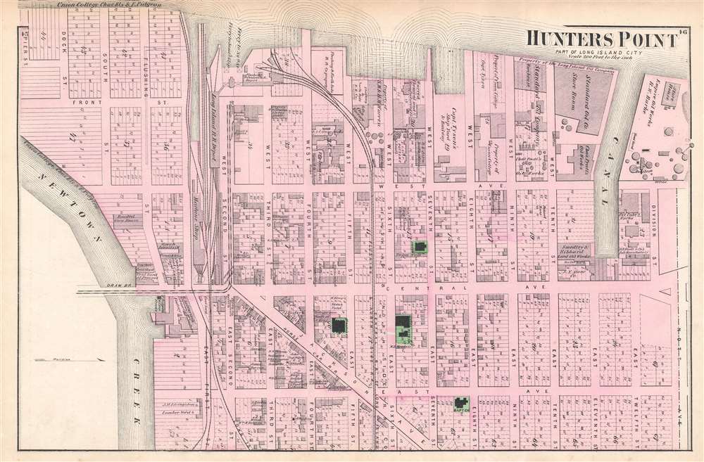
A scarce example of Fredrick W. Beers' 1873 map of Hunter's Point (Long Island City), Queens, New York. The map depicts part of what is today Long Island City from Pier Street north as far as Nott Avenue. Among the identified locations are the Long Island Railroad depot, several churches, a school, and Standard Oil's 'store room'. Individual lots are identified. This is probably the finest atlas map of Hunters Point, Queens, to appear in the 19th century.
Publication History
Prepared by 'Beers, Comstock and Cline' out of their office at 36 Vesey Street, New York City, for inclusion in the first published atlas of Long Island, the 1873 issue of Atlas of Long Island, New York.Cartographer
The Beers family (Fredrick, Silas, James and Daniel) (fl. c. 1850 - 1886), along with Charles and Augustus Warner, were prominent map publishers working from the 1850s to the late 1880s. Often publishing under the Warner & Beers designation, the combined firms produced a series of important state and county atlases and map of much of the northeastern United States. Many of their regional maps are among the most detailed and well laid out maps ever produced of their respective regions. Because Warner & Beers county maps were often detailed down to the individual homes and landowners, they have become highly sought after by general and family historians. In additional to producing maps of surpassing detail, Warner & Beers also maintained an earlier generation's attention to detail and quality while publishing in an era ever increasingly dominated by the low cost printing methods used by the publishing empires of Rand McNally and George Cram. More by this mapmaker...
Source
Beers, F. W., Atlas of Long Island, New York. From Recent Actual Surveys and Records Under the Superintendence of F. W. Beers, (New York: Beers) 1878, First Edition.
Condition
Very good. Closed margin tears professionally repaired on verso. Maps of Winfield, Middle Village, and part of Astoria on verso.
References
New York Public Library, Map Division, 1527278. Rumsey 0066.030. Philips (Atlases) 2202.