1947 Alf Cooke Map of India, Economic Production
India-cookealf-1947$1,000.00

Title
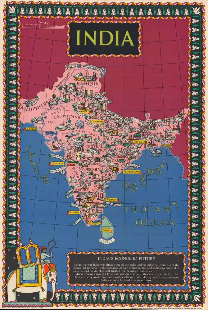
India / India's Economic Future.
1947 (undated) 29 x 19.5 in (73.66 x 49.53 cm) 1 : 8500000
1947 (undated) 29 x 19.5 in (73.66 x 49.53 cm) 1 : 8500000
Description
A beautiful c. 1947 Alf Cooke pictorial map of India, produced on the eve of independence and partition. It highlights the goods produced by the Raj and posits a bright future for the subcontinent.
A Closer Look
The map reflects the vast diversity of the Indian subcontinent through its economic output, ranging from raw minerals and petroleum, to staples like wheat, millet, and rice, to commodities like cotton, tea, and sugar. Heavier industries, such as shipbuilding and steel works, point to the country's hoped-for economic future. Illustrations represent these economic activities, while text labels some of the provinces, princely states, and geographic regions. An intricate border with a flower motif surrounds the map.India in War and Peace
As referred to in the text at bottom-right, though World War II (1939 - 1945) was a tumultuous period in India, with civil disobedience against British imperial rule, religious strife, and a horrific famine in Bengal, the need for war materiel was beneficial to India's economy and finances. However, the traumatic experience of 1947 partition and its aftermath damaged economic prospects, at least temporarily. Under the administration of Jawaharlal Nehru (1952 - 1964), India followed a socialist modernization model inspired by the Soviet Union, which did result in some expansion of heavy industry as well as the construction of roads, dams, canals, and railways.Publication History and Census
This map was printed by Alf Cooke around the year 1947 and was distributed by British Information Services, a propaganda outfit in the Foreign and Commonwealth Office established in 1941 to promote British interests in the United States, which explains its New York City location noted here. There are two editions of the map: one held by the David Rumsey Historical Map Collection dates to c. 1943 and the text box at bottom is titled 'India in War and Peace,' while the present edition dates to c. 1947, with the box title as 'India's Economic Future.' Regardless of edition, it is scarce to the market and is only listed among the institutional holdings of the British Library, the Library of Congress, the University of Michigan, the University of Wisconsin-Milwaukee, the University of Chicago, and the University of Minnesota, Twin Cities.Cartographer
Alf Cooke (1842 - 1902) was born in Hunslet, Leeds. In 1866, he established a business there selling newspapers, stationary, and letterpress prints which he had made. He quickly moved into chromolithographic prints and found great success, relocating to Headingley in the early 1870s. In 1880, a fire destroyed his shop and he had to start over nearly from scratch but was able to repeat and even exceed his earlier successes. His print shop developed a specialty in chromolithographed portraits, such as of Queen Victoria, which were extremely popular. In 1885 he was granted a Royal Warrant as 'Chromolithographer to Her Majesty' and afterwards preferred to be called 'the Queen's Printer.' Around the same time, he moved into a grand country estate (Weetwood Hall) to match his lofty reputation. Cooke also entered politics and in 1890 was elected Mayor of Leeds. In 1894, his print shop burned down again but a grand new factory was quickly built on the same site - the building still stands and is now part of Leeds City College. After Alf's death in 1902, his sons took over the company - it was merged twice in the following decades but continued to use the name 'Alf Cooke' for many years, even after the founder's descendants were no longer involved in its operation. The company eventually became part of the Bemrose Corporation, which produced printing and packaging products. More by this mapmaker...
Condition
Very good. Wear along centerfold, especially at top.
References
Rumsey 8565.000 (1943 edition). OCLC 1110660281.