1946 Army Information Branch Pictorial Wall Map of Iran
IranVolIVNo44F-newsmap-1946$550.00

Title
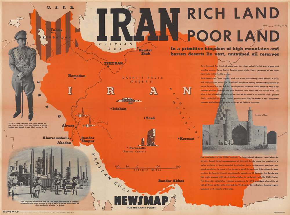
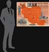
Iran. Rich Land Poor Land.
1946 (dated) 34.25 x 46 in (86.995 x 116.84 cm)
1946 (dated) 34.25 x 46 in (86.995 x 116.84 cm)
Description
This is a 1946 Army Information Branch pictorial map of Iran. Published during the Iran Crisis of 1946, dark brown stripes emphasize Iranian Azerbaijan, then occupied by Soviet troops and where two pro-Soviet separatist 'republics' were established. This crisis ranks as one of the first of the Cold War (1947 - 1991).
Small pictorial icons mark Persepolis and a tent appears above Isfahan. Two oil derricks are illustrated near Ahwaz, continuing the theme of the American obsession with Middle Eastern oil.
A Closer Look
The text present on the map's right offers a short history of Iran, followed by a short discussion of its strategic position and oil fields. The text describing the Iran Crisis appears below the photograph of the Mosque of Suz. A full-length portrait of Mohamed Reza Pahlevi is situated to the left, along with a photograph of British troops guarding an Iranian oil refinery.Small pictorial icons mark Persepolis and a tent appears above Isfahan. Two oil derricks are illustrated near Ahwaz, continuing the theme of the American obsession with Middle Eastern oil.
The Iran Crisis of 1946
One of the first crises of the Cold War, the Iran Crisis of 1946 (known as the Azerbaijan Crisis in Iranian sources) was ignited after the Soviet Union refused to leave occupied Iranian territory following World War II. On August 25, 1941, the Soviet Union and United Kingdom occupied Iran (a neutral country) as a supposedly preventive measure. They justified this action by stating that securing Iran was a wartime necessity, and that the country would serve as an artery for Lend-Lease supplies from British India to the Soviet Union. This joint occupation forced the abdication of Reza Shah (who was exiled to Mauritius) and the ascension of his son Mohammad Reza Pahlavi. In January 1941, Iran, the Soviet Union, and the United Kingdom signed a 'Tripartite Treaty' which declared Iran their ally, stated that the British and Soviet military presence was not an occupation, and that British and Soviet forces would leave Iran within six months of the end of the war. Iran became an important supply line throughout the rest of the war, used by both the British and Americans to ferry supplies to the Soviets. Tehran even hosted the Big Three (Roosevelt, Churchill, and Stalin) for the Tehran Conference in 1943. The Americans and British both adhered to the agreed upon six-month timeline for removing their troops, but Stalin kept Soviet troops in Iran past the March 2 deadline, even extending their military presence southward during the six months that followed. The Soviet Union also encouraged the creation of two pro-Soviet 'People's Democratic Republics': the Azerbaijan People's Republic and the Kurdish Republic of Mahabad.Resolution of the Crisis
The nascent United Nations played a critical role in ending this crisis. United Nations Security Council issued Resolution 2, 3m adb 5 encouraged Iran and the Soviet Union to resolve the crisis. The United States played an important role by exerting intense diplomatic pressure. Eventually, Soviet troops withdrew and both separatist states were dissolved.Life After the Army?
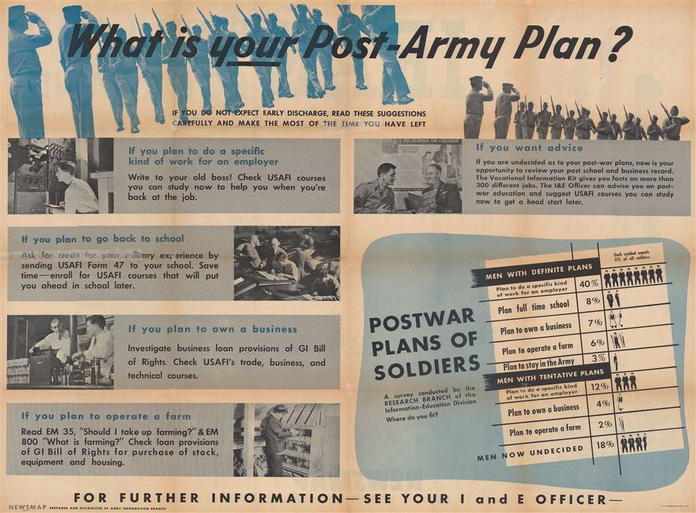
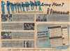
As with most Newsmaps, the verso is also rich with interesting content. With this edition, the verso asks: 'What is your Post-Army Plan?' The broadside provides advice, offering several plans, including working for a previous employer, going back to school, starting their own business, or operating a farm. It cites specific Army programs and suggests asking for advice from their Information and Education officer.Publication History and Census
This map was created by the Army Information Branch and published on February 18, 1946. We note seven examples cataloged in OCLC: Denison University, Ohio Wesleyan University, Davidson College, the Library of Michigan, Southern Illinois University at Edwardsville, the University of Missouri, and the Denver Public Library. We also note examples at the Hoover Institution, the University of North Texas, and the Harry S. Truman Presidential Library and Museum.Source
Army Information Branch. 'Monday, 18 February, 1946. Week of 5 February to 12 February. Volume IV No. 44F.'.
Newsmaps were published weekly between April 1942 and March 1946. Their content usually featured world maps, short summaries of the week’s military action, and photographs of troops and materiel. Early Newsmaps were printed on one side only, but, later in the war, they were printed on both sides, with the reverse bearing large-format maps, photographs, or other visual information. Several different versions of Newsmaps were produced: a large domestic version, a smaller overseas version, and an industrial version, which included more information about war production efforts. Two other editions appear in the United States Government Publications Monthly Catalogs, a 'Newsmap Special Edition' and a 'Newsmap Special Supplement for Special Training Units'.
Per the National Archives and Records Administration, ‘NEWSMAPS were not issued for general distribution. The posters were distributed to military installations, government and civilian groups working on War Department projects, and certain depository libraries, as designate by Congress, and one copy to Congressmen, if requested.’ The importance of the Newsmaps to the Army is related in the 1944 Basic Field Manual for The Special Service Company. The Manual states that as soon as the company reaches its destination ‘the company commander should contact the Special Service Branch in theater of operations headquarters, for copies of the weekly Newsmap.’ Also per the Manual
Per the National Archives and Records Administration, ‘NEWSMAPS were not issued for general distribution. The posters were distributed to military installations, government and civilian groups working on War Department projects, and certain depository libraries, as designate by Congress, and one copy to Congressmen, if requested.’ The importance of the Newsmaps to the Army is related in the 1944 Basic Field Manual for The Special Service Company. The Manual states that as soon as the company reaches its destination ‘the company commander should contact the Special Service Branch in theater of operations headquarters, for copies of the weekly Newsmap.’ Also per the Manual
The librarian should check the weekly Newsmap as soon as it is made available and should post it in a conspicuous place. He should take steps to see that the place where the Newsmap is posted is made known to all troops of the area in which the company or platoon is operating. This can be done effectively through notices in soldier newspapers, verbal announcements by those directly in charge of troops, and by posting announcements on bulletin boards.
Condition
Very good. Wear along original fold lines. Verso repairs to fold separations and at fold intersections. Closed margin tears professionally repaired on verso. Slight loss at some fold intersections.
References
Hoover Institution Library and Archives Poster US 7842. University of North Texas W 109.207:4/44. Harry S. Truman Presidential Library and Museum M1788. OCLC 60931089.