This item has been sold, but you can get on the Waitlist to be notified if another example becomes available, or purchase a digital scan.
1866 Mitchell Map of Ireland and Scotland
IrelandScotland-mitchell-1866$50.00

Title
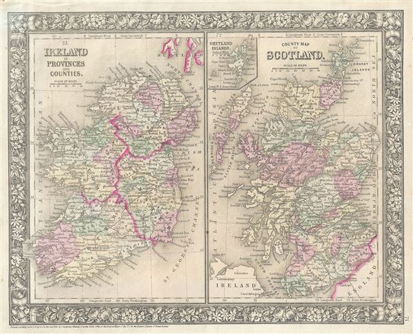
Ireland in Provinces and Counties. County Map of Scotland.
1860 (dated) 11.5 x 14 in (29.21 x 35.56 cm) 1 : 2400000
1860 (dated) 11.5 x 14 in (29.21 x 35.56 cm) 1 : 2400000
Description
This is a beautiful example of the American map publisher Samuel Augustus Mitchell Jr.'s 1866 map of Scotland and Ireland. Essentially two maps on a single sheet, this map details all of Ireland and Scotland with an inset map of the Shetland Islands. The map on the right covers Scotland in full from the Orkney Islands to Wigton in the south, inclusive of the Hebrides. The left hand side map covers the emerald isle in full from Donegal to Cork, divided into its four primary provinces, Munster, Ulster, Connaught and Leinster as well as its various provinces.
During the 19th century, Ireland suffered a series of famines, the worst one being the Great Irish Famine, which lasted from 1845 – 1849 and killed about a million people. As a result it witnessed widespread immigration. By the end of the 19th century, almost 50% of immigrants into the United States were from Ireland. At the same time Scotland was in the midst of its industrial revolution and emerging as center for engineering and shipbuilding.
This map also identifies various cities, towns, rivers and an assortment of additional topographical details. Map is color coded according to political boundaries with elevation rendered by hachure. The whole is surrounded by the attractive floral border common to Mitchell atlases between 1860 and 1866. One of the most attractive American atlas maps of this region to appear in the mid-19th century.
Prepared by S. A. Mitchell Jr. for inclusion as plate 71 in the 1866 issue of Mitchell's New General Atlas. Like many American map publishers of this period, Mitchell did not regularly update his copyright, consequently this map is dated and copyrighted to 1860: 'Entered according to Act of Congress in the Year 1860 by S. Augustus Mitchell Jr. in the Clerks Office of the District Court of the U.S. for the Eastern District of Pennsylvania.'
Cartographer
Samuel Augustus Mitchell (March 20, 1792 - December 20, 1868) began his map publishing career in the early 1830s. Mitchell was born in Bristol, Connecticut. He relocated to Philadelphia in 1821. Having worked as a school teacher and a geographical writer, Mitchell was frustrated with the low quality and inaccuracy of school texts of the period. His first maps were an attempt to rectify this problem. In the next 20 years Mitchell would become the most prominent American map publisher of the mid-19th century. Mitchell worked with prominent engravers J. H. Young, H. S. Tanner, and H. N. Burroughs before attaining the full copyright on his maps in 1847. In 1849 Mitchell either partnered with or sold his plates to Thomas, Cowperthwait and Company who continued to publish the Mitchell's Universal Atlas. By about 1856 most of the Mitchell plates and copyrights were acquired by Charles Desilver who continued to publish the maps, many with modified borders and color schemes, until Mitchell's son, Samuel Augustus Mitchell Junior, entered the picture. In 1859, S.A. Mitchell Jr. purchased most of the plates back from Desilver and introduced his own floral motif border. From 1860 on, he published his own editions of the New General Atlas. The younger Mitchell became as prominent as his father, publishing maps and atlases until 1887, when most of the copyrights were again sold and the Mitchell firm closed its doors for the final time. More by this mapmaker...
Source
Mitchell Jr., S. A., Mitchell's New General Atlas, Containing Maps Of The Various Countries Of The World, Plans Of Cities, Etc. Embraced In Forty-Seven Quarto Maps, Forming A Series Of Seventy-Six Maps And Plans, Together With Valuable Statistical Tables, 1866 edition.
Condition
Very good. Minor overall toning and fading. Minor foxing.
References
Rumsey 0565.036 (1860 edition). Phillips (Atlases) 831. New York Public Library, Map Division, 1510831.