This item has been sold, but you can get on the Waitlist to be notified if another example becomes available, or purchase a digital scan.
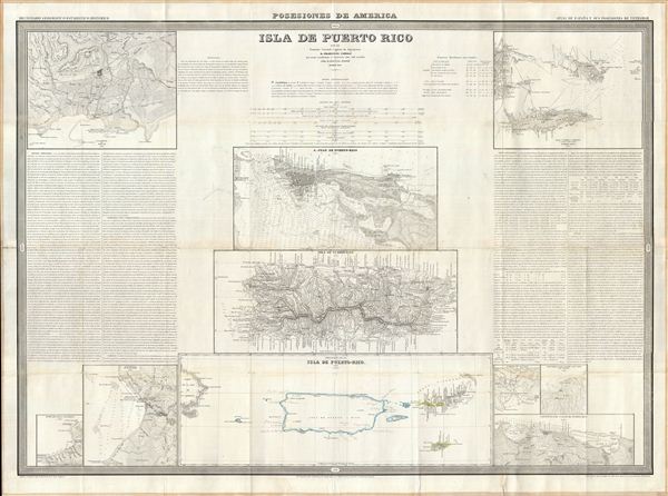
1851 Coello Map of Puerto Rico (Porto Rico)
IsladePuertoRico-coello-1851$1,150.00

Title
Isla de Puerto Rico por el Teniente Coronel Capitan de Ingenieros D. Francisco Coello, las notas estadisticas e historicas han sido escritas por D. Pascual Madoz. Madrid 1851.
1851 (dated) 31 x 42 in (78.74 x 106.68 cm) 1 :1000000
1851 (dated) 31 x 42 in (78.74 x 106.68 cm) 1 :1000000
Description
A fine example of Francisco Coello de Portugal y Quesada's massive map of Puerto Rico. Coello's map is the first scientifically produced Spanish map of Puerto Rico. The map is essentially ten individual maps on a signal sheet with extensive historical and statistical annotation. This sheet details Puerto Rico, San Juan, and eight other maps of ports, neighboring islands and important geographical features. Longitude is measured from Madrid. The 19th century was a period of great change for Puerto Rico and witnessed the abolishment of the slave trade, the 1851 founding of the Royal Academy of Belles Letters, the introduction of wired communication, and the rise of the Puerto Rican sovereignty movement. Engraved by D. Juan Noguera in Madrid as map no. 41 for Coello's unfinished opus Atlas de España y sus posesiones de Ultramar.
Cartographer
Francisco Coello de Portugal y Quesada (1822 - September 30, 1898) was a Spanish cartographer, explorer, and military engineer active in the mid-19th century. Coello was born in Jaen, Spain and joined the military in 1833, enrolling at the Special Army Corps of Engineers Academy of Guadalajara. Upon graduating with honors he joined Corps of Military Engineers where after serving in the First Carlist War, and later in Algeria, he attained the rank of Colonel. Coello later founded the Geographical Society of Madrid and served many years as its president. He was also a corresponding member of the American Geographical Society and a full member of the Real Sociedad Geográfica de España. Coello's greatest work, his monumental Atlas de España y sus posesiones de Ultramar, was truncated by his death in 1898 and consequently never completed. Nevertheless, the work is of historical significance as the first scientifically produced maps of Spain, Cuba, and Porto Rico. More by this mapmaker...
Source
Coello, F., Atlas de España y sus posesiones de Ultramar, (Madrid) 1851.
Condition
Very good. Professionally flattened and backed on linen.
References
Rumsey 5011.001. Phillips (Atlases) 9323, 3137.