
This item below is out of stock, but another example (left) is available. To view the available item, click "Details."
Details
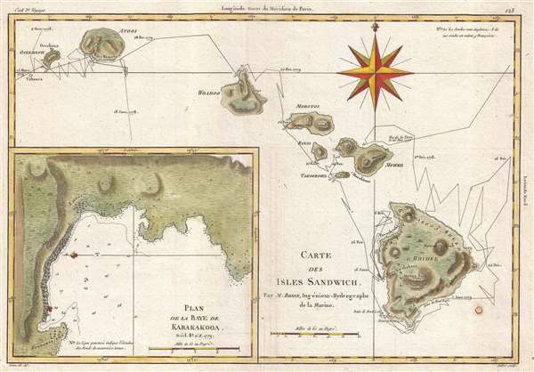
1788 Bonne Map of the Hawaii / Hawaiian Islands
1788 (undated) $750.00
1788 Bonne Map of the Hawaiian Islands
IslesSandwich-bonne-1788$337.50

Title
Carte des Isles Sandwich.
1788 (undated) 9.5 x 13.5 in (24.13 x 34.29 cm) 1 : 900000
1788 (undated) 9.5 x 13.5 in (24.13 x 34.29 cm) 1 : 900000
Description
This is a 1788 Rigobert Bonne map of the Hawaiian Islands and part of the third and final voyage of Captain James Cook. The map depicts Hawaii, Maui, Lanai, Molokai, Oahu, Kauai, and Nihau. The route followed by the ships is illustrated in detail on the map along with dates at certain points. An inset map of the Bay of Karakakooa is situated in the lower left corner.
With the goal of discovering the Northwest Passage, Cook discovered the Islands on his way to the Pacific coast of North America. After reaching the Bering Strait and discovering that he could not continue east or west, Cook and his party returned to Hawaii. It was here, at the Bay of Karakakooa, on the 14th of February 1779, that James Cook met his fate. After a series of quarrels with native Hawaiians, violence broke out and Captain Cook was killed, along with four marines. His second in command, Charles Clerke, to over command, but he succumbed to tuberculosis only a few months later. The voyage never achieved their goal of finding the Northwest Passage and returned to England in October 1780.
This map was drawn by Rigobert Bonne in 1778.
Cartographer
Rigobert Bonne (October 6, 1727 - September 2, 1794) was one of the most important French cartographers of the late 18th century. Bonne was born in Ardennes à Raucourt, France. He taught himself mathematics and by eighteen was a working engineer. During the War of the Austrian Succession (1740 - 1748) he served as a military engineer at Berg-op-Zoom. It the subsequent years Bonne became one of the most respected masters of mathematics, physics, and geography in Paris. In 1773, Bonne succeeded Jacques-Nicolas Bellin as Royal Cartographer to France in the office of the Hydrographer at the Depôt de la Marine. Working in his official capacity, Bonne compiled some of the most detailed and accurate maps of the period - most on an equal-area projection known erroneously as the 'Bonne Projection.' Bonne's work represents an important step in the evolution of the cartographic ideology away from the decorative work of the 17th and early 18th century towards a more scientific and practical aesthetic. While mostly focusing on coastal regions, the work of Bonne is highly regarded for its detail, historical importance, and overall aesthetic appeal. Bonne died of edema in 1794, but his son Charles-Marie Rigobert Bonne continued to publish his work well after his death. More by this mapmaker...
Condition
Very good. Slight wear along original centerfold. Verso repairs in lower right quadrant. Blank on verso.
References
OCLC 643751390.