1982 Defense Mapping Agency Bilingual Space Shuttle Mission Chart of Orbits for STS-7
JPMissionChartSTS7-defensemapping-1982$750.00

Title
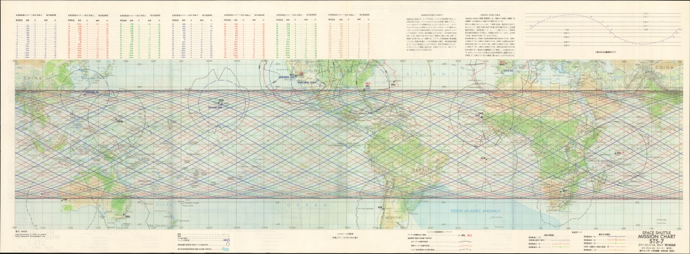
Space Shuttle Mission Chart STS-7 / スペースシャトル STS-7 飛行経路図.
1982 (dated) 15 x 40 in (38.1 x 101.6 cm) 1 : 40000000
1982 (dated) 15 x 40 in (38.1 x 101.6 cm) 1 : 40000000
Description
A curious relic of the early Space Shuttle era, this map presents a 1983 Japanese translation of the Defense Mapping Agency's mission chart of shuttle mission STS-7, launched the previous year, historically significant as the first American space flight to include a female astronaut, Sally Ride. Curiously, this map was issued as a supplement to the Japanese adult magazine Weekly Playboy (週刊プレイボーイ).
One side of the map matches perfectly with the original Defense Mapping Agency mission chart produced in December 1982 (previously sold by us), while the other side retains the data and presentation of the recto of the original map, with data and explanation translated to Japanese. The data at top is compressed somewhat to allow for text explaining to the reader what exactly a mission chart is and how to read it (見方).
A Closer Look
Printed on both sides, colored lines represent each of Space Shuttle Challenger's 97 orbits during STS-7. (STS stands for Space Transport System and was the official name for the Space Shuttle program.) Orbits are divided into groups, such as Orbits 1 through 16, Orbits 17 through 32, etc., with each orbit numerically identified. Orbits 1 through 64 are illustrated on the recto, and 65 through 116 are depicted on the verso. Antenna locations and call letters are identified by black or red block lettering, and solid black and/or red lines illustrate the effective range at these tracking and communication stations. Blue call letters label airfields where the Space Shuttle could land.One side of the map matches perfectly with the original Defense Mapping Agency mission chart produced in December 1982 (previously sold by us), while the other side retains the data and presentation of the recto of the original map, with data and explanation translated to Japanese. The data at top is compressed somewhat to allow for text explaining to the reader what exactly a mission chart is and how to read it (見方).
STS-7 and Space Shuttle Challenger
STS-7 launched on June 18, 1983, and landed six days later at Edwards Air Force Base on June 24. During the six-day mission, Challenger's five-person crew (including Sally Ride) conducted experiments, deployed 2 communications satellites (one for Canada and one for Indonesia), and Challenger carried the first Shuttle pallet satellite. Challenger landed at Edwards Air Force Base after. The planned landing at Kennedy Space Center was forced to change due to bad weather. Challenger flew 10 missions, spent 62 days in space, and completed 1,000 orbits of the Earth. Tragically, Challenger was destroyed 73 seconds after liftoff on January 28, 1986, killing the seven-member crew of STS-51-L.Publication History and Census
This mission chart was published on September 30, 1983 as part of a special thematic work titled Honoh no hi [炎の日] : Cosmo-Sapience titled 'Space Shuttle Story' (スペースシャトルのストーリー ), a supplement to the adult magazine Weekly Playboy (週刊プレイボーイ) (published by Shūeisha 集英社). It is based on the 1982 U.S. Defense Mapping Agency mission chart of STS-7. The bilingual map is not independently cataloged, nor is the Defense Mapping Agency's 1982 original, while the entire work Honoh no hi : Cosmo-Sapience is held by the Library of Congress and National Diet Library.Condition
Very good. Light wear along original fold lines. Unrepaired split at two fold intersections.
References
OCLC 15407534, 703988587 (entire work).


