1750 Bellin Map of the East Indies (Sumatra, Malay, Java, Borneo)
JavaSumatraBorneo-bellin-1780$275.00

Title
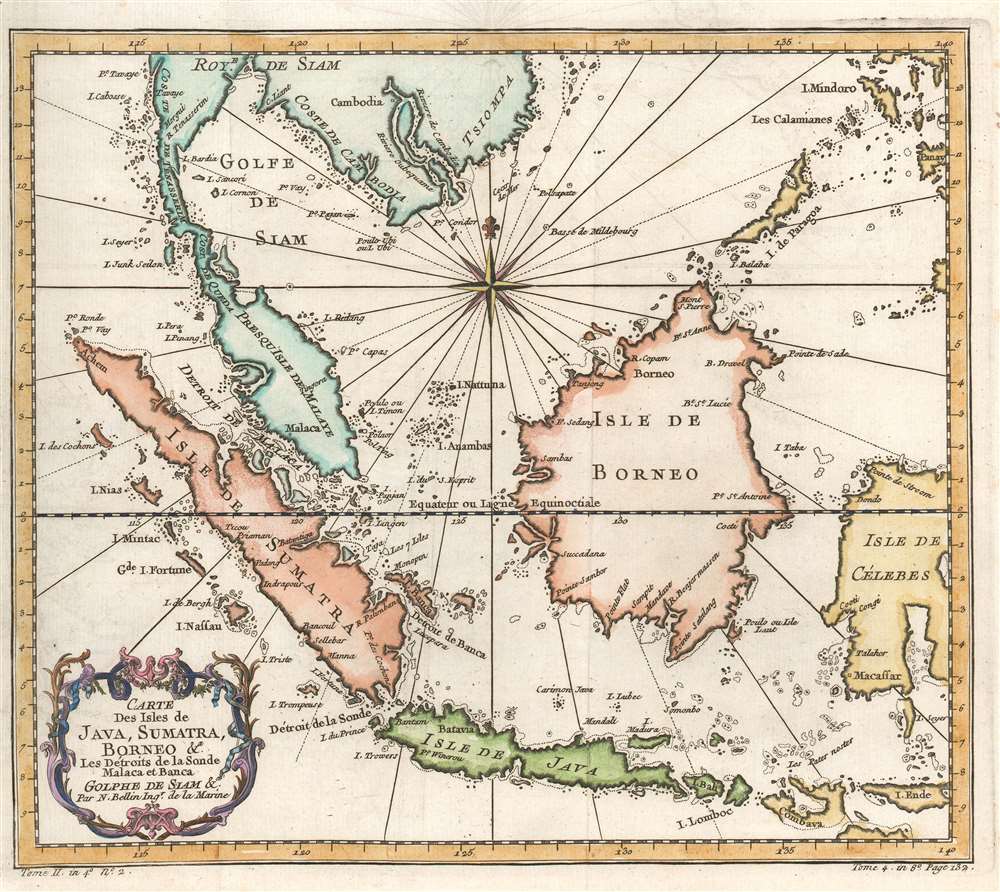
Carte des Isles de Java, Sumatra, Borneo et les détroits de la Sonde Malaca et Banca Golphe de Siam.
1780 (undated) 10.5 x 11.5 in (26.67 x 29.21 cm) 1 : 11000000
1780 (undated) 10.5 x 11.5 in (26.67 x 29.21 cm) 1 : 11000000
Description
This is an attractive c.1780 Jacques Nicholas Bellin map of the East Indies. The map depicts from Siam (Thailand) and Tsiompa (modern day Vietnam) south to include the Sumatra, Java, and Borneo. The Malay Peninsula (Malacca), Singapore, Borneo, Sumatra, Java, and part of Celebes (Sulawesi), are included. Impressive detail appears along all the coastlines, however little inland information is present, as is common for Bellin's nautical charts. Singapore remains unidentified, but several other lesser islands are noted including Tioman Island (Poulo ou I. Timon) and Penang. A beautifully engraved rocco title cartouche adorns the lower left corner of the map.
Publication History and Census
This map was created by Jacques Nicholas Bellin and published in 1780 by De la Harpe in his Abrégé de l'Historie générale des Voyages. Four examples are cataloged in OCLC and are part of the institutional collections at Cornell University, the University of Hawaii, the Bayerische Staatsbibliothek in Munich, and the Unversitätsbibliothek München in Munich.Cartographer
Jacques-Nicolas Bellin (1703 - March 21, 1772) was one of the most important cartographers of the 18th century. With a career spanning some 50 years, Bellin is best understood as geographe de cabinet and transitional mapmaker spanning the gap between 18th and early-19th century cartographic styles. His long career as Hydrographer and Ingénieur Hydrographe at the French Dépôt des cartes et plans de la Marine resulted in hundreds of high quality nautical charts of practically everywhere in the world. A true child of the Enlightenment Era, Bellin's work focuses on function and accuracy tending in the process to be less decorative than the earlier 17th and 18th century cartographic work. Unlike many of his contemporaries, Bellin was always careful to cite his references and his scholarly corpus consists of over 1400 articles on geography prepared for Diderot's Encyclopedie. Bellin, despite his extraordinary success, may not have enjoyed his work, which is described as "long, unpleasant, and hard." In addition to numerous maps and charts published during his lifetime, many of Bellin's maps were updated (or not) and published posthumously. He was succeeded as Ingénieur Hydrographe by his student, also a prolific and influential cartographer, Rigobert Bonne. More by this mapmaker...
Source
De la Harpe, Abrégé de l'histoire générale des voyages. (Paris) 1780.
Condition
Very good. Even overall toning. Exhibits light offsetting. Blank on verso.
References
OCLC 163338680.