1840 QMG Manuscript Map of Kandahar, Afghanistan and its Immediate Environs
KandaharVillages-qmg-1840$2,000.00

Title
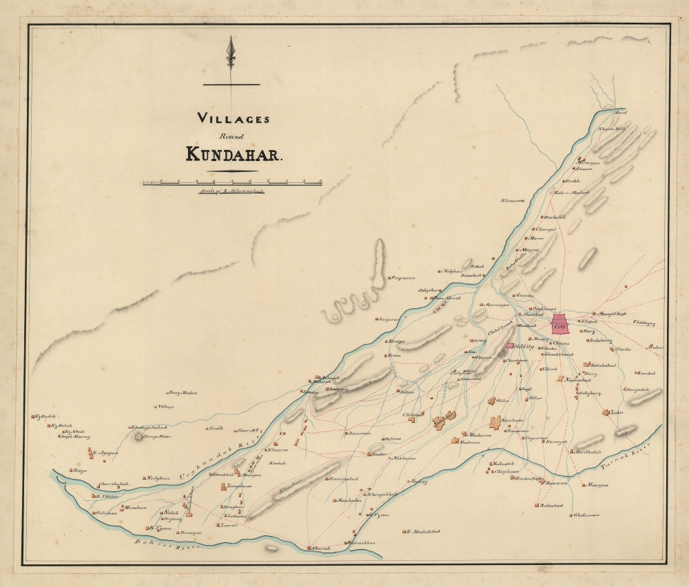
Villages of Kundahar.
1840 (undated) 16 x 18.75 in (40.64 x 47.625 cm) 1 : 126720
1840 (undated) 16 x 18.75 in (40.64 x 47.625 cm) 1 : 126720
Description
An exquisitely drafted manuscript map of the Kandahar, Afghanistan, and its immediate environs during the First Anglo-Afghan War (1839 - 1942). Resplendently drafted and colored by the Indian Quartermaster General's Office (QMG), the map incorporates traditional Bengali handmade inks. During this conflict, Kandahar was the most important British base in Afghanistan, and the surrounding region was a theater of fierce and constantly evolving guerrilla war. The present map must be the result of direct field mapping, likely completed under wartime conditions, yet nonetheless represents one of the earliest accurate maps of Kandahar and its immediate vicinity. With Kandahar (labeled simply as 'City') situated close to the right border, the map depicts the region in detail, identifying numerous villages and using boxes of varying size to indicate each villages population relative to all the others. The Urghundhab River flows diagonally across the map, and two major tributaries, the Dohree River and Turnuk River, are identified while dozens of smaller ones are illustrated. Red dashed lines mark roads between the settlements, with nearly all of them leading back to Kandahar. This is, moreover, one of very few surviving original manuscript maps from First Anglo-Afghan War, the first (not the last) major western foray into Afghanistan.
In order to secure the Afghan frontier, the British sent an embassy to the Emir of Afghanistan, Dost Mohammad Khan, with whom they hoped to confirm an anti-Russian alliance. Although Dost Mohammad was interested in a British-Afghan alliance, both sides had conflicting interests. Afghanistan had recently lost Peshawar, its second capital, to the powerful the Sikh Empire, with whom the British were allied. Thus, the British had to choose to ally with either the Afghan, Dost Mohammad, or the Sikhs. They believed the Sikh Empire, which maintained a powerful French-trained standing army, the Dal Khalsa, to be the greater alliance, and so took a third path.
Unable to forge an alliance with Dost Mohammad (Barakzai), the British instead turned to the exiled former Emir Shah Shujah (Durrani). Unlike Dost Mohammad, who was fierce, wily, and dogged, Shah Shujah had a reputation for indolence and cruelty, reportedly having a penchant for removing the noses, ears, tongues, penises, and testicles of his courtiers and slaves when they displeased him in the slightest. Nonetheless, the British considered him, for his very indolence, to be malleable and thus preferable to Dost Mohammad.
The British mustered the massive 'Grand Army of the Indus', consisting of some 21,000 British, Indian, and Sikh troops and marched into Afghanistan from Punjab under the command of Baron John Keane. By March 1839, they had successfully crossed the 4000-meter-high Bolan Pass, from which they pushed forward to seize Kandahar on April 25, 1839. Cognizant of the harsh conditions of the region, they waited until the crops ripened in mid-June to begin further conquests. It was probably around this time that survey work for the present meticulously detailed map was completed. Often at great cost, the British Grand Army won most major engagements, but the dogged Dost Mohammad simply retreated further into the countryside and continued to wage a persistent guerrilla war against the British.
Eventually Dost Mohammad was captured and the British decided they had achieved their objectives. Most of the Army returned to India, leaving just 8000 troops to support the Shah Shujah puppet regime. When Dost Mohammed escaped from prison in Bokhara and returned to Afghanistan the fighting recommenced. While retreating in January 1842, the main British Indian and Sikh force occupying Kabul, along with their camp followers, was almost completely annihilated. The British sent an 'Army of Retribution' to Kabul but, by the end of the year, Dost Mohammad resumed his rule. The British called this war 'The Disaster in Afghanistan' and Dost Mohammad is reported to have said:
The overall mastery of execution suggests that the map was drafted in one of the primary QMG branches, likely either Calcutta or Simla, rather than in Kandahar itself. It was likely produced to provide officials in India in charge of war planning an idea of the area immediately surrounding Kandahar. Since Kandahar served as the main British base during the First Anglo-Afghan War, hostilities and guerrilla attacks continued throughout the war. By producing this map, military leaders in India could have more concrete understanding of the dispatches they received from commanders in the field.
The First Anglo-Afghan War (1839 - 1842)
Fought between the British East India Company and the Emirate of Afghanistan, the First Anglo-Afghan War was part of 'The Great Game,' a larger diplomatic confrontation between the British and Russian Empires. While Russia probably never seriously considered invading India, it was actively expanding into Central Asia. The British East India Company, and by extension the British Empire, nonetheless feared the Russians would move through their central Asian provinces, then through Afghanistan, into India, undermining British hegemony in South Asia.In order to secure the Afghan frontier, the British sent an embassy to the Emir of Afghanistan, Dost Mohammad Khan, with whom they hoped to confirm an anti-Russian alliance. Although Dost Mohammad was interested in a British-Afghan alliance, both sides had conflicting interests. Afghanistan had recently lost Peshawar, its second capital, to the powerful the Sikh Empire, with whom the British were allied. Thus, the British had to choose to ally with either the Afghan, Dost Mohammad, or the Sikhs. They believed the Sikh Empire, which maintained a powerful French-trained standing army, the Dal Khalsa, to be the greater alliance, and so took a third path.
Unable to forge an alliance with Dost Mohammad (Barakzai), the British instead turned to the exiled former Emir Shah Shujah (Durrani). Unlike Dost Mohammad, who was fierce, wily, and dogged, Shah Shujah had a reputation for indolence and cruelty, reportedly having a penchant for removing the noses, ears, tongues, penises, and testicles of his courtiers and slaves when they displeased him in the slightest. Nonetheless, the British considered him, for his very indolence, to be malleable and thus preferable to Dost Mohammad.
The British mustered the massive 'Grand Army of the Indus', consisting of some 21,000 British, Indian, and Sikh troops and marched into Afghanistan from Punjab under the command of Baron John Keane. By March 1839, they had successfully crossed the 4000-meter-high Bolan Pass, from which they pushed forward to seize Kandahar on April 25, 1839. Cognizant of the harsh conditions of the region, they waited until the crops ripened in mid-June to begin further conquests. It was probably around this time that survey work for the present meticulously detailed map was completed. Often at great cost, the British Grand Army won most major engagements, but the dogged Dost Mohammad simply retreated further into the countryside and continued to wage a persistent guerrilla war against the British.
Eventually Dost Mohammad was captured and the British decided they had achieved their objectives. Most of the Army returned to India, leaving just 8000 troops to support the Shah Shujah puppet regime. When Dost Mohammed escaped from prison in Bokhara and returned to Afghanistan the fighting recommenced. While retreating in January 1842, the main British Indian and Sikh force occupying Kabul, along with their camp followers, was almost completely annihilated. The British sent an 'Army of Retribution' to Kabul but, by the end of the year, Dost Mohammad resumed his rule. The British called this war 'The Disaster in Afghanistan' and Dost Mohammad is reported to have said:
I have been struck by the magnitude of your resources, your ships, your arsenals, but what I cannot understand is why the rulers of so vast and flourishing an empire should have gone across the Indus to deprive me of my poor and barren country.The First Anglo-Afghan was the opening salvo of the Great Game, which, one might argue, is still being fought over control of Afghanistan.
The Great Game - The Struggle for Afghanistan
'The Great Game' was a diplomatic confrontation between the British and Russian Empires over Afghanistan and other territories in Central and Southern Asia. The conflict, rooted in long-standing animosity between Russia and Britain, revolved around Afghanistan, which, while lacking significant resources of its own, was strategically situated. For its part, Russia feared Britain was making commercial and military inroads into Central Asia, an area long within the sphere of influence of St. Petersburg. Britain, conversely, feared Russia making gains in India, 'the jewel in the crown' of British Asia. The escalating tensions led to several wars and proxy wars: The First Anglo-Afghan War (1839 - 1842), the First Anglo-Sikh War (1845 - 1846), the Second Anglo-Sikh War (1848 - 1849), and the Second Anglo-Afghan War (1878 - 1880), along with the Russian annexations of Khiva, Bukhara, and Kokand. Then as now, Afghanistan proved a grinding stone upon which the world's great empires diminished themselves, none achieving a definitive victory despite committing staggering resources. The Great Game ended on September 10, 1895 with the signing of the Pamir Boundary Commission Protocols, which stabilized the border between Afghanistan and the Russian Empire.Sources, Construction, and Use
No significant mapping of the Kandahar region occurred before 1838 and the First Anglo-Afghan War. In December of 1838, in anticipation of field action, the QMG sent the military surveyor William Fraser-Tyler to begin preliminary covert reconnaissance. Fraser-Tyler's work yielded basic cartography for the districts to the north and west of Kandahar, including the Helmand and Arghandab valleys. Additional survey work in the regions west and southwest of Kandahar was completed during the 1839 British occupation under Major William Garden and Captain John Paton. While the presently offered map directly copies neither, and there is no other antecedent map, it is likely that the draftsman had access to both and could have referenced them when composing this piece.The overall mastery of execution suggests that the map was drafted in one of the primary QMG branches, likely either Calcutta or Simla, rather than in Kandahar itself. It was likely produced to provide officials in India in charge of war planning an idea of the area immediately surrounding Kandahar. Since Kandahar served as the main British base during the First Anglo-Afghan War, hostilities and guerrilla attacks continued throughout the war. By producing this map, military leaders in India could have more concrete understanding of the dispatches they received from commanders in the field.
Publication History and Census
We are aware of no antecedent map and no publication of the present map. This is a unique primary record of the early days of the First-Anglo Afghan War and the work of the QMG in this region. Few cartographic records survive from this era, making the present map a unique once-in-a-lifetime discovery.Cartographer
India Quartermaster General Office (1803 - 1947), a major branch of the QMG, was the division of the British Indian Army responsible for logistics and mapping. Among other duties, the QMG employed detachments of military engineers to conduct and compile surveys of conflict theaters. The QMG was based in Calcutta, but established several annex branches, in Simla (Himachal Pradesh, India), Colombo, and elsewhere. Master cartographers, surveyors, and draftsmen under the QMG traveled throughout British India and the adjacent regions, compiling detailed surveys in anticipation of trade, war, or both. Working in diverse and sometimes onerous conditions, they developed sophisticated cartographic conventions while at the same time adapting to local supplies and resources. Some, for example, have noted the QMG maps often have resplendent bright color - these are palettes adapted from Indian handmade watercolors traditionally used in the Bengali textile industry. These attractive colors were later adapted into the general British cartographic palette. Few QMG maps were ever published, most surviving only in manuscript, in institutional archives like the British Library’s India Office Records. Moreover, despite their significance, no comprehensive survey of surviving of India QMG maps has been compiled, resulting in their being generally underappreciated and misunderstood. The QMG remained active in India until the British withdraw in 1947. More by this mapmaker...
Condition
Very good. Mounted on another sheet of paper.