This item has been sold, but you can get on the Waitlist to be notified if another example becomes available, or purchase a digital scan.
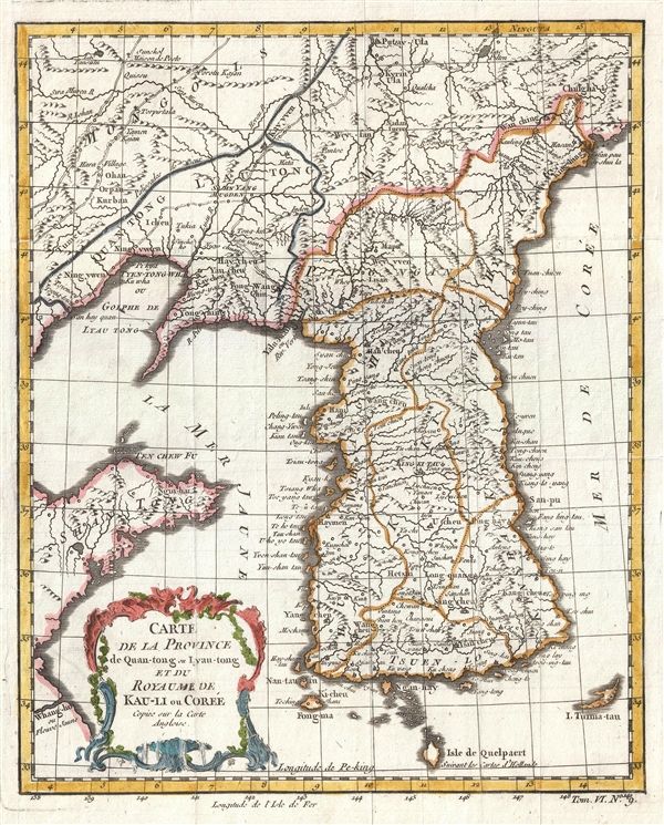
1749 Bellin Map of Korea (Showing Sea of Korea)
KauliCoree2-bellin-1749$250.00

Title
Carte de la Province de Quan-tong, ou Lyau-tong et du Royaume de Kau-li ou Coree .
1749 (undated) 11.5 x 9.5 in (29.21 x 24.13 cm) 1 : 5000000
1749 (undated) 11.5 x 9.5 in (29.21 x 24.13 cm) 1 : 5000000
Description
This is an uncommon 1749 map of Korea by Jacques Nicholas Bellin. Centered on the west coast of Korea (Corea), this map covers all of peninsular Korea as well as adjacent parts of Manchuria and China. Korea, as presented here takes on a trapezoidal form with a wide flat base. The map names numerous cities and provinces throughout Korea as well as noting coastal islands and ports. Cartographically Bellin derived this map from an earlier though less specific 1735 map by J. B. B. D'Anville. The detail presented throughout the interior makes it clear that D'Anville drew his map based upon Korean sources - a first for a European cartographer. The map changed little under Bellin.
The sea between Japan and Korea, whose name, either the 'Sea of Korea', 'East Sea', or the 'Sea of Japan,' is here identified in favor of Korea as Mer de Coree. Historically, Korea has used the term 'East Sea' since 59 B.C., and many books published before the Japanese annexation of Korea make references to the 'East Sea' or 'Sea of Korea.' Over time, neighboring and western countries have identified Korea's East Sea using different terms. The St. Petersburg Academy of Sciences referred to the East Sea as 'Koreiskoe Mope' or 'Sea of Korea' in their 1745 map of Asia. Other seventeenth and 18th century Russian maps alternate between 'Sea of Korea' and 'Eastern Ocean'. The 18th century Russian and French explorers Adam Johan von Krusenstern and La Perouse called it the 'Sea of Japan', a term that subsequently became popular worldwide. Nonetheless, the last official map published by the Russians uses 'East Sea' and 'Sea of Korea'. The name is currently still a matter of historical and political dispute between the countries.
This is one of three maps that Bellin drew including Korea - the other two of which cover a much larger area. Bellin prepared this map for Antoine-Francois Prevost's Historie General des voyages.
Cartographer
Jacques-Nicolas Bellin (1703 - March 21, 1772) was one of the most important cartographers of the 18th century. With a career spanning some 50 years, Bellin is best understood as geographe de cabinet and transitional mapmaker spanning the gap between 18th and early-19th century cartographic styles. His long career as Hydrographer and Ingénieur Hydrographe at the French Dépôt des cartes et plans de la Marine resulted in hundreds of high quality nautical charts of practically everywhere in the world. A true child of the Enlightenment Era, Bellin's work focuses on function and accuracy tending in the process to be less decorative than the earlier 17th and 18th century cartographic work. Unlike many of his contemporaries, Bellin was always careful to cite his references and his scholarly corpus consists of over 1400 articles on geography prepared for Diderot's Encyclopedie. Bellin, despite his extraordinary success, may not have enjoyed his work, which is described as "long, unpleasant, and hard." In addition to numerous maps and charts published during his lifetime, many of Bellin's maps were updated (or not) and published posthumously. He was succeeded as Ingénieur Hydrographe by his student, also a prolific and influential cartographer, Rigobert Bonne. More by this mapmaker...
Source
Prévost, A., Histoire Générale des Voyages, ou Nouvelle Collection de Toutes les Relations de Voyages par Mer et par Terre..., (Paris: Didot) 1746 - 1759, Supplements 1761 - 1801.
Prévost's Histoire Générale des Voyages is a 15-volume compendium of travel literature initiated by Antoine François Prévost (Provost; 1697 - 1763) in 1746, intended as a universal history of exploration and geography. The initial publication, compiled from 1746 to 1759, spans 15 volumes and draws from a vast array of sources - travelers, explorers, missionaries, merchants, and diplomats - to present detailed narratives of significant global journeys. The work was initially published in Paris by Didot and offers ethnographic, political, religious, and natural observations about the peoples, cultures, flora, fauna, and geography. It is an ambitious attempt to organize knowledge about the world's diversity according to Enlightenment values, reflecting both scientific curiosity and imperial ideology. It functioned as both an informative reference and a literary work, influencing how European audiences understood and imagined distant lands. It proved extremely successful, and both reissues other publishers and pirate editions emerged, most notably Pierre de Hondt's 1747 Dutch edition and Jean-Franćois de la Harpe's 1780 abridged version. In addition to reissues of the original work, between 1768 and 1801, additional expanded volumes emerged, adding new voyages and histories. We have seen some sets with as many as 80 volumes. Over time, the Histoire générale des voyages became one of the most comprehensive and widely read travel collections of the 18th century, notable for blending factual reporting with the period's characteristic intellectual ambition.
Condition
Very good. Minor wear along original fold lines. Original platemark visible.
References
Harvard Map Collection, Map Coll (Pusey) MAP-LC G7900 1749 .B4.