1823 Tanner Map of Kentucky and Tennessee
KentuckyTennessee-tanner-1823$1,500.00

Title
Kentucky and Tennessee by H. S. Tanner.
1823 (dated) 21 x 28 in (53.34 x 71.12 cm) 1 : 1140480
1823 (dated) 21 x 28 in (53.34 x 71.12 cm) 1 : 1140480
Description
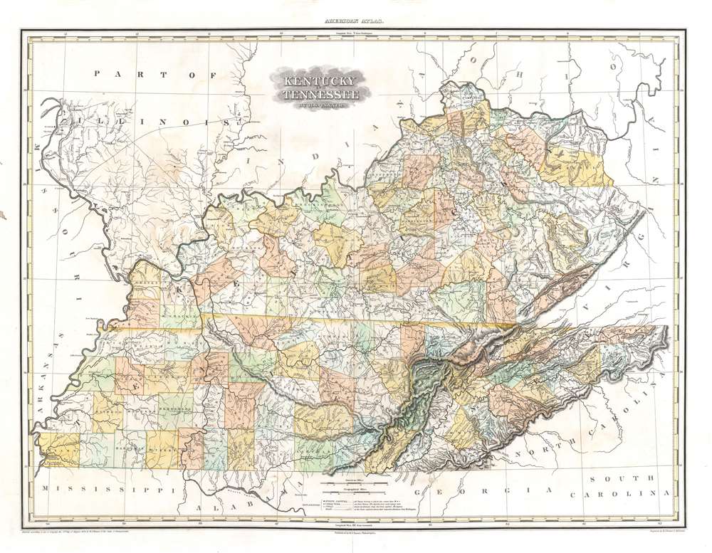
This is a rare transitional state of Henry S. Tanner's 1823 map of Kentucky and Tennessee. The map captures the creation of Wood Lake following the New Madrid Earthquakes.
A Closer Look
This elephant folio map covers Kentucky and Tennessee in full, with parts of neighboring states. The map is a strong example of Tanner's superb engraving, showing rivers, topography by hachure, cities, towns, and roadways. Various natural features and resources are also marked: in Clay County, Kentucky, for example, a 'Burning Spring' is noted - a stream around which natural gas escapes from the ground, which may be set alight. Salt works, iron mines, colleges, and 'oil springs' all find their way into this detailed map.New Counties Added following the Chickasaw Cession
Throughout the map, Kentucky and Tennessee's counties are named and made more distinguishable with wash color. In the westernmost counties of Tennessee, we see the greatest change in the map: in the first state, many of these are marked but left unnamed. Here, (in addition to the removal of the reference to Illinois from the title) the counties of Hardeman (Hardiman), McNairy (McVarry), Haywood, Tipton, Dyer, Gibson, Obion, and Weakley ('Weakly') are newly named. This example was included in an 1823 edition of the Atlas, indicating that Tanner updated the work piecemeal before the publication of the 1825/6 edition. That latter edition includes this map, unchanged beyond the notation in the title 'improved to 1825.'The Aftermath of the New Madrid Earthquakes
The newly-named 'Obion County' is shown with a 'Reelfoot R.' which, though having been identified in a 1785 survey, had ceased to exist 11 years before the engraving of this map. In 1811 and 1812, the whole region was devastated by the New Madrid Earthquakes. As a result, this area subsided and produced an enormous lake and swamp area. On the map, this is shown as Wood Lake and Wood Lake Swamp. Today, it is known as Reelfoot Lake. Eliza Bryan, an eyewitness to the earthquakes, wrote in 1816 of the appearance of this astonishing new lake:Lately it has been discovered that a lake was formed on the opposite side of the Mississippi River, in the Indian country, upwards of one hundred miles in length, and from one to six miles in width, of the depth of from ten to fifty feet. It has communication with the river at both ends, and it is conjectured that it will not be many years before the principal part, if not the whole of the Mississippi, will pass that way.The depiction of Wood Lake and its attendant swamp agrees largely with Bryan's report, starting nearly opposite New Madrid across the Mississippi and running south until meeting and presumably emptying into the Obion River.
Why Illinois
The original title of this map was Kentucky, Tennessee and part of Illinois. The Illinois portion of the map is highly detailed here, which is unusual for Tanner in a non-focus region. His 1823 atlas did include a more specific map of Illinois and Missouri. We thus speculate that this map was completed before Tanner committed to producing a dedicated Illinois map.Publication History and Census
The map was engraved by Tanner (and his assistants) for inclusion in the 1823 edition of his New American Atlas; we see about 20 examples of the originally-titled 1823 edition of this separate map in OCLC. We see the 1825 edition marked 'improved to 1825' in about 17 institutional collections. While we are compelled to make allowances for errors in cataloging, the present example is much scarcer than either the 1823 or 1825, with four or perhaps five examples showing this title without the 1825 note.Cartographer
Henry Schenck Tanner (1786 - May 18, 1858) was one of the preeminent American map engravers and publishers of the early 19th century - what is considered to be the "Golden Age of American Map Publishing". Born in New York City but based in Philadelphia, Tanner's forty plus year career was almost entirely focused on cartographic work. His earliest map work appears in conjunction with another important map publisher, John Melish. Early in his career, Tanner partnered with his brother Benjamin, to engrave extensively for Melish as well as other Philadelphia publishers including Lucas Fielding (Baltimore), A. Bourne, Jason Torey, Samuel Harrison, and Samuel Lewis, among others. In 1818 Tanner convinced his fellow publishers and partners to finance the compilation of a New American Atlas. The atlas was sold by subscription and slowly emerged between 1819 and 1823. The New American Atlas, possibly the pinnacle of 19th century American cartography and was commended in its day as "one of the most splendid works of the kind ever executed in this country". It was subsequently republished in several updated editions until about 1839. Tanner had by this time become the most active and influential map publisher in the United States. Around 1832, recognizing the market for a less cost prohibitive atlas, Tanner began work on the smaller format New Universal Atlas. This popular and important atlas went through numerous editions before being bought out by Carey and Hart, and then, in 1846, by S. A. Mitchell, who would rise to become the preeminent publisher of the next generation. In addition to these important atlases, Tanner also issued numerous extremely important and influential travelers guides, state maps, wall maps, and pocket maps. He should not be confused with his brother, also an America map engraver, the New Yorker Benjamin Tanner. More by this mapmaker...
Source
Tanner, H. S., A New American Atlas, (Philadelphia: Tanner) 1825.
Tanner's New American Atlas is regarding as the largest and most beautiful early American atlas, truly a landmark achievement from the Golden Age of American Cartography. The atlas was initially published in five parts between 1819 and 1823, after which collected editions were issued in 1823, 1825, 1833, and 1839. It terms of size, format, printing quality, paper quality, cartographic accuracy, and elegance of engraving, the New American Atlas was unparalleled. As noted by map historian Walter Ristow, 'Tanner's atlas raised U.S. commercial map production to a new level of excellence.' His contemporaries were also duly impressed. The American educator and historian Jared Sparks, as quoted by Ristow, describes the atlas as thus:
on the whole as an American Atlas, we believe Mr. Tanner’s work to hold a rank far above any other, which has been published. The authentic documents, to which he had access, the abundance of his materials, the apparent fidelity, with which they are compiled, the accurate construction of his maps, and the elegance with which they are executed, all these afford ample proofs of the high character of the work, of its usefulness as a means of extending the geographic knowledge of our own country, and of its claims to public patronage. (Ristow, p. 197)
Condition
Very good. Minor wear on original centerfold. Some odd and faint waterstains.
References
Rumsey 2755.013. Phillips (Atlases) P4463.