Title
江蘇 / Kiangsu.
1933 (undated)
24.25 x 29.25 in (61.595 x 74.295 cm)
1 : 900000
Description
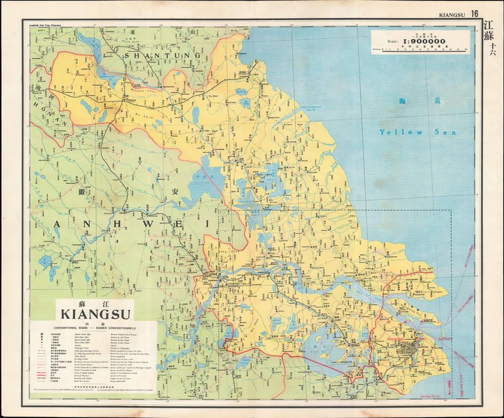
This is a map of Jiangsu (Kiangsu) Province from the 1933 edition of The Postal Atlas of China (中華郵政輿圖), compiled by Charles Jacot-Guillarmod. It highlights the evolving postal infrastructure of the region, reflecting a broader modernization drive by the Nanjing government.
Jiangsu between Two Worlds
The importance of waterways for Jiangsu are evident here, particularly the Yangtze River at bottom. For most of the imperial era, these waterways were the primary means of long-distance transportation and formed a sort of highway system in ancient China, most impressively the Grand Canal (運河, here as Yün Ho), stretching over 1,000 miles between Beijing and Hangzhou. By the early 20th century, upkeep of the Grand Canal and other waterways had slackened due to natural disasters, warfare, and viable alternatives, especially as maritime travel became faster and less expensive, and railways became more widespread.
Jiangsu could be considered a microcosm of China in the Republican era (1912 – 1949), containing within it the modern metropolis of Shanghai, impressive ancient cities like Suzhou and Nanjing, and a vast, impoverished countryside, especially north of the Yangzi River. People from this region, known as Subei (蘇北, 'northern Jiangsu') or Jiangbei (江北, 'north of the Yangzi River') people, sought refuge in Shanghai and other cities from natural disasters, warfare, banditry, and starvation in the countryside, forming an urban underclass of servants, laborers, rickshaw drivers, and prostitutes.
Nevertheless, Jiangsu benefitted from the modernization efforts of the Nanjing government in this period (described below) and further investment in the People's Republic era, especially in the past 30 years. Even excluding Shanghai, which is now a separate provincial-level administration, Jiangsu is one of the wealthiest regions of China today.The Nanjing Decade
Nanjing became the capital city of China in 1927-28, following the partial reunification of the country by Chiang Kai-Shek's (1887 - 1975) forces in the Northern Expedition. A key turning point in this effort was the Shanghai 'White Terror' of April 1927, when Chiang enlisted the criminal Green Gang to murder Communist agents and activists who had called a general strike in the city. This marked a definitive break between the Nationalists and Communists, who had been cooperating in an uneasy alliance to unify the country up to that point.
After purging the Communists, Chiang established a new national regime in Nanjing. In the decade that followed, despite weak authority, multiple civil wars, a Communist insurgency, and an incremental Japanese invasion of northern China, the Nanjing Government and the Kuomintang were able build something like a modern, functioning bureaucratic state, particularly in the Lower Yangtze Delta around Nanjing and Shanghai, and successfully complete a string of hallmark infrastructure and modernization projects. Nevertheless, full-scale war with Japan in 1937 derailed these efforts, leading ultimately to Chiang's retreat to Taiwan and the Communist takeover of mainland China in 1949.The Postal Atlas of China (中華郵政輿圖)
Compiled by Charles Jacot-Guillarmod, this atlas contains maps covering all of China in considerable detail. Most were derived from regional working postal maps. The legends on the maps are written in English, Chinese, and French. The history of the The Postal Atlas of China is closely related to attempts to Romanize placenames in the Chinese Postal System. The first atlas followed the 1906 Shanghai Imperial Postal Joint-Session Conference to develop a system of Romanization following Herbert Giles' 'Nanking Syllabary.' The Giles 'Nanking syllabary' was popular with the French-dominated Chinese Postal Service, which considered the earlier Beijing based system developed by Thomas Francis Wade as too Anglophone. As was the case for other bureaucratic offices at this time, foreign advisors were often brought in as consultants or even government officials.
The second edition of the Postal Atlas was issued in 1919 following a Ministry of Education system to standardize the Beijing dialect in all elementary schools throughout China. This led to a resurgence of the Wade system. Nonetheless, in 1931, the French postal co-director Henri Picard-Destelain ordered a return to the Nanking Syllabary. The Chinese Postal System remained under French management until 1943 when the Japanese invaders ousted A. M. Chapelain, the last French head of the China Post.Publication History and Census
There are four known editions of this atlas: 1907-08 (Shanghai, replacing the 1903 postal wall map, 21 maps plus index map), 1919 (Beijing, 47 maps), 1933 (Nanjing), and 1936 (Nanjing). The atlas was compiled by the French topographical engineer Charles Jacot-Guillarmod and published by the Directorate General of Posts (郵政總局). This edition is held by a handful of university libraries and research institutions in North America and Europe, as well as institutions in mainland China and Taiwan.
Cartographer
Charles Jacot-Guillarmod (1868 – August 14, 1925) was a Swiss topographical engineer active in the late 19th and early 20th century. Charles was born in Le Chaux-de-Fonds, in the Canton of Neuchatel, Switzerland. He attended the Eidgenössische Technische Hochschule Zürich (ETHZ), where he acquired a degree in Topographical Engineering. After graduating served the Swiss Federal Topographical Bureau from 1890 – 1914, contributed significantly to the Topographical Atlas of Switzerland. He was dismissed from his government topographical posted in 1914. Independent of a paid post he turned his attentions to his interested in high alpine cartography, producing two topographical sketches of Himalayan peaks (K2 and Kanchenjunga) based upon photographs taken by his cousin, the famed mountaineer Jules Jacot-Guillarmod. From 1916 to 1922 he relocated to Beijing where he taught geodesy and topography at the Chinese Army Survey School. There, he was also contracted to compile the 1919 second edition of the China Postal Atlas. When the Chinese government could no longer pay him, he returned to Switzerland in 1923 where he compiled a large scale topographic map of Mount Olympus. His final work was a large scale map of Mount Everest commissioned by the Royal Geographical Society, London, based upon the surveying achievements of a British expedition. More by this mapmaker...
Source
China. You zheng zong ju, Zhonghua min guo you zheng yu tu, (Nanking: Directorate General of Post) 1933.
Condition
Very good. Periodic light dampstaining, especially at top and bottom margin.
References
OCLC 5371414, 17468267.