This item has been sold, but you can get on the Waitlist to be notified if another example becomes available, or purchase a digital scan.
1744 Bellin Charlevoix Map of the Great Lakes (a seminal map)
LacsduCanada3-bellin-1744$1,500.00

Title
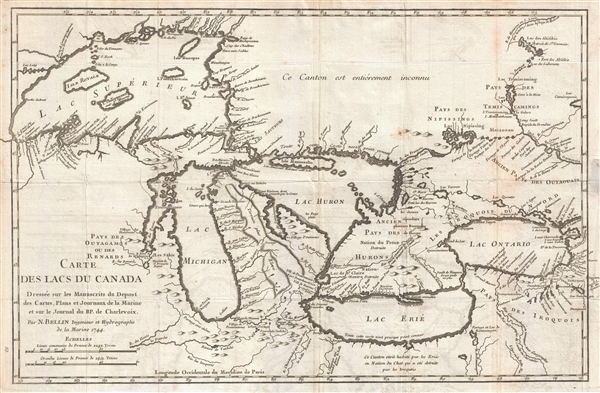
Carte des Lacs du Canada Dresse sur les Manuscrits du Depost des Carts, Plans et Journaux de la Marine et sur le Journal de RP. De Charlevoix.
1744 (dated) 11.5 x 17.5 in (29.21 x 44.45 cm) 1 : 3376000
1744 (dated) 11.5 x 17.5 in (29.21 x 44.45 cm) 1 : 3376000
Description
An iconic and historically influential 1744 map of the Great Lakes by Jacques-Nicholas Bellin. Possibly Bellin's most important production, this is the earliest obtainable map, preceded only by a 1742 proof noted by Kershaw, to depict the four fictive islands in Lake Superior (Philippeux, Pontchartrain, Maurepas, and St. Anne) - islands that nonetheless significantly influenced the structuring of post-Revolutionary War borders between British Canada and the fledgling United States. It is also notable for being among the earliest maps to identify Detroit and the Port of Chicago. Bellin's map covers all five Great Lakes and their adjacent drainage systems in considerable detail, noting known fortifications, American Indian villages, missions, and some speculative topography (particularly in Michigan).
Bellin prepared this map to illustrate Pierre François Xavier de Charlevoix's Histoire et description generale de la Nouvelle France, however it is primarily based upon the manuscripts compiled by Gaspard-Joseph Chaussegros de Lery, a French Canadian military engineer active throughout the Great Lakes region in the early 18th century. Charlevoix himself was a Jesuit missionary and traveler commissioned by the French Crown and the Duke of Orleans to reconnoiter French holdings in the Americas. The French had just lost control of the Hudson Bay and were actively in search of a profitable route to the Pacific, which many believed lay in the network of rivers and lakes to the west of the Great Lakes. Charlevoix thus had the secondary commission to 'inquire about the Western Sea, but [to] still give the impression of being no more than a traveler or missionary.'
It was Charlevoix who invented the four spurious islands in Lake Superior, here noted as Philippeaux, Pontchartrain, Maurepas, and St. Anne. The islands were intended to honor Charlevoix' s personal patron, the Count of Maurepas, Jean-Frederic Phelypeaux. The largest of the three islands, Philippeaux, is named directly after the count. The second largest island, Pontchartrain, refers to Phelypeaux's family estate. The third island, which may in fact be a mismapping of the factual State Islands, is named after the count's seat, Maurepas. The fourth and smallest of the islands, St. Anne, references the count's patron saint. Charlevoix described the islands as being rich in minerals leading numerous explorers to search for them in vain. Bellin dutifully introduced the four islands to his map, offered here, and such was his influence that they were subsequently copied by most subsequent cartographers, including John Mitchell in his seminal 1755 wall map of North America. The highly regarded Mitchell map was used in negotiating the 1783 Treaty of Paris that formally concluded the American Revolutionary War. Therein, the apocryphal Philippeaux was assigned as a marker for the new United States - British America border thus setting the stage, as one might image, for later political strife.
Charlevoix's history and this map in particular thus proved exceptionally influential as one of the most comprehensive works on North America predating the French and Indian War. Copies of the Histoire et Description Generale were to be found in the libraries of many 18th century luminaries, including Voltaire, Franklin, and Jefferson. Jefferson in particular admired Charlevoix work, calling it 'a particularly useful species of reading' and no doubt influenced his decision to pursue the historic 1802 Louisiana Purchase, possibly the most significant event in the post-colonial history of North America.
Cartographer
Jacques-Nicolas Bellin (1703 - March 21, 1772) was one of the most important cartographers of the 18th century. With a career spanning some 50 years, Bellin is best understood as geographe de cabinet and transitional mapmaker spanning the gap between 18th and early-19th century cartographic styles. His long career as Hydrographer and Ingénieur Hydrographe at the French Dépôt des cartes et plans de la Marine resulted in hundreds of high quality nautical charts of practically everywhere in the world. A true child of the Enlightenment Era, Bellin's work focuses on function and accuracy tending in the process to be less decorative than the earlier 17th and 18th century cartographic work. Unlike many of his contemporaries, Bellin was always careful to cite his references and his scholarly corpus consists of over 1400 articles on geography prepared for Diderot's Encyclopedie. Bellin, despite his extraordinary success, may not have enjoyed his work, which is described as "long, unpleasant, and hard." In addition to numerous maps and charts published during his lifetime, many of Bellin's maps were updated (or not) and published posthumously. He was succeeded as Ingénieur Hydrographe by his student, also a prolific and influential cartographer, Rigobert Bonne. More by this mapmaker...
Source
Charlevoix, Pierre François Xavier de, Histoire et description generale de la Nouvelle France, avec le journal historique d'un voyage fait par ordre du roi dans l'Amérique septentrionnale, (Paris) 1744.
Condition
Very good. A strong impression. Light foxing. Slight wear, toning, and minor edge verso reinforcment on original fold lines.
References
Goss, J., The Mapping of North America: Three Centuries of Map-Making 1500-1860, no. 56. Kershaw, K. A., Early Printed Maps of Canada, no. 947. Karpinski, L. C., Bibliography of the Printed Maps of Michigan, 1804-1880, p. 137. Schwartz, S. and Ehrenberg, R., The Mapping of America, p.162