1771 Bonne Map of Languedoc and Roussillon, France
Languedoc2-bonne-1771$200.00

Title
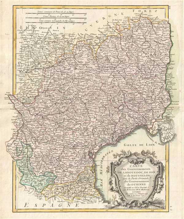
Carte des Gouvernements de Languedoc, de Foix et de Roussillon avec la Partie Orientale du Gouvernement de Guinne.
1771 (dated) 16 x 14 in (40.64 x 35.56 cm) 1 : 930000
1771 (dated) 16 x 14 in (40.64 x 35.56 cm) 1 : 930000
Description
This is a 1771 Rigobert Bonne decorative map of the French winemaking regions of Languedoc, de Foix and Roussillon. The map depicts the regions in full from Auvergne and Limosin to Spain and the Mediterranean. Highly detailed, myriad cities and towns are labeled, including Montpellier, Nimes, Carcassonne, and Toulouse. Numerous rivers and mountain ranges snake across the region.
Montpellier is one of the largest cities in modern France, and it is a university city. Nimes was the capital of the Roman province of Narbonne under Emperor Augustus. Today, people can visit the arena in the center of town, the Maison Carrée, a well-preserved temple, and the spectacular Pont du Gard, a Roman aqueduct. Carcassonne is famous because it is a medieval fortified town that is also a UNESCO World Heritage site. This region is also the largest producer of wine in France. The Camargue, a wetland region, is also depicted. Over 400 species of birds inhabit the Camargue, including flamingos! The Camargue is also home to Camargue horses and cattle. A large decorative title cartouche appears on the lower right.
This map was drawn by Rigobert Bonne in 1771 for issue in Jean Lattre's 1776 issue of the Atlas Moderne.
CartographerS
Rigobert Bonne (October 6, 1727 - September 2, 1794) was one of the most important French cartographers of the late 18th century. Bonne was born in Ardennes à Raucourt, France. He taught himself mathematics and by eighteen was a working engineer. During the War of the Austrian Succession (1740 - 1748) he served as a military engineer at Berg-op-Zoom. It the subsequent years Bonne became one of the most respected masters of mathematics, physics, and geography in Paris. In 1773, Bonne succeeded Jacques-Nicolas Bellin as Royal Cartographer to France in the office of the Hydrographer at the Depôt de la Marine. Working in his official capacity, Bonne compiled some of the most detailed and accurate maps of the period - most on an equal-area projection known erroneously as the 'Bonne Projection.' Bonne's work represents an important step in the evolution of the cartographic ideology away from the decorative work of the 17th and early 18th century towards a more scientific and practical aesthetic. While mostly focusing on coastal regions, the work of Bonne is highly regarded for its detail, historical importance, and overall aesthetic appeal. Bonne died of edema in 1794, but his son Charles-Marie Rigobert Bonne continued to publish his work well after his death. More by this mapmaker...
Jean Lattré (170x - 178x) was a Paris based bookseller, engraver, globe maker, calligrapher, and map publisher active in the mid to late 18th century. Lattré published a large corpus of maps, globes, and atlases in conjunction with a number of other important French cartographic figures, including Janvier, Zannoni, Bonne and Delamarche. He is also known to have worked with other European cartographers such as William Faden of London and the Italian cartographer Santini. Map piracy and copyright violations were common in 18th century France. Paris court records indicate that Lattré brought charges against several other period map publishers, including fellow Frenchman Desnos and the Italian map engraver Zannoni, both of whom he accused of copying his work. Lattré likes trained his wife Madame Lattré (né Vérard), as an engraver, as a late 18th century trade card promotes the world of 'Lattré et son Epouse.' Lattré's offices and bookshop were located at 20 rue St. Jaques, Paris, France. Later in life he relocated to Bordeaux. Learn More...
Source
Lattre, Jean, Atlas Moderne ou Collection de Cartes sur Toutes les Parties du Globe Terrestre, c.1778.
Condition
Very good. Even overall toning. Original press mark visible. Blank on verso.
References
Rumsey 2612.017. Phillips (Atlases) 664. National Maritime Museum, 215.