Digital Image: 1879 Sizer / Baldwin Map of Mining Claims Near Leadville, Colorado
LeadvilleColorado-baldwin-1879_d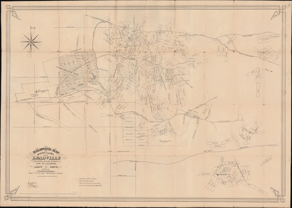


Title
Baldwin's Map of Mining Claims, Near Leadville California Mining District, Lake co. Colorado.
1879 (dated) 27.25 x 38.25 in (69.215 x 97.155 cm) 1 : 9600
1879 (dated) 27.25 x 38.25 in (69.215 x 97.155 cm) 1 : 9600
Description
FOR THE ORIGINAL ANTIQUE MAP, WITH HISTORICAL ANALYSIS, CLICK HERE.
Digital Map Information
Geographicus maintains an archive of high-resolution rare map scans. We scan our maps at 300 DPI or higher, with newer images being 600 DPI, (either TIFF or JPEG, depending on when the scan was done) which is most cases in suitable for enlargement and printing.
Delivery
Once you purchase our digital scan service, you will receive a download link via email - usually within seconds. Digital orders are delivered as ZIP files, an industry standard file compression protocol that any computer should be able to unpack. Some of our files are very large, and can take some time to download. Most files are saved into your computer's 'Downloads' folder. All delivery is electronic. No physical product is shipped.
Credit and Scope of Use
You can use your digial image any way you want! Our digital images are unrestricted by copyright and can be used, modified, and published freely. The textual description that accompanies the original antique map is not included in the sale of digital images and remains protected by copyright. That said, we put significant care and effort into scanning and editing these maps, and we’d appreciate a credit when possible. Should you wish to credit us, please use the following credit line:
Courtesy of Geographicus Rare Antique Maps (https://www.geographicus.com).
How Large Can I Print?
In general, at 300 DPI, you should at least be able to double the size of the actual image, more so with our 600 DPI images. So, if the original was 10 x 12 inches, you can print at 20 x 24 inches, without quality loss. If your display requirements can accommodate some loss in image quality, you can make it even larger. That being said, no quality of scan will allow you to blow up at 10 x 12 inch map to wall size without significant quality loss. For more information, it is best consult a printer or reprographics specialist.
Refunds
If the high resolution image you ordered is unavailable, we will fully refund your purchase. Otherwise, digital images scans are a service, not a tangible product, and cannot be returned or refunded once the download link is used.
Cartographer S
Frank Leonard Sizer (September 29, 1856 - July 11, 1942) was an American civil and mining engineer active at various sites. He was born Ottawa, Illinois, and studied engineering and surveying at the University of Michigan. On graduating, he moved to Leadville, Colorado, then in the early days of the Colorado Silver Boom (1879 - 1893). He stayed there for several years, mapping mining claims, before relocated to Helena Montana Territory by March of 1882. There he was both a chief clerk in the surveyor general's office, and maintained private business interests. He was a partner in Sizer and Keerl (with James S. Keerl), a Colorado mining concern active from 1890 - 1897. In 1901 he spent a year consulting at the Rosario Mine in Chihuahua, Mexico. He participated at various levels in numerous other mines throughout Montana and was active in various trade organizations. In 1909, he moved to California where in 1942 he died at his home in Berkeley. More by this mapmaker...
Morgan Lithograph (1864 - Present) was founded in 1864 by William J. Morgan (1838 - 1904) and George W. Morgan (1843 - 1905) as W. J. Morgan and Comapny. William was born in Wales and Gorge was born in Pittsburgh, Pennsylvania after the family emigrated. This issued trade cards, broadsheets, maps, pamphlets, postcards, and advertising posters. By the late 1880s, the firm focused almost entirely on colorful large-scale chromolithographs for the circus industry, with Ringling Brothers being their primary client. The name of the firm was simplified to Morgan Lithograph in 18987. They won gold medals at both the 1889 Paris Exposition and the 1893 Columbian Exposition in Chicago for their high quality large-format lithographs. The firm still operates in Cleveland, Ohio. The firm famously produced the political posters for William McKinley's 1896 presidential campaign. In the early 20th century, they segued into film posters for the nascent motion picture company. The firm remains in operation in Cleveland after nearly 160 years. Learn More...
References
New York Public Library, Map Div. 21-33. OCLC 8085469, 81333946. Phillips (America), page 357.