Digital Image: 1632 / 1647 Famiano Strada Leo Belgicus Map of the Netherlands in its first, Rome Edi
LeoBelgicus-strada-1632_d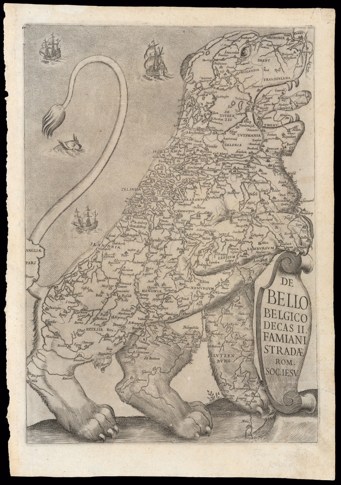

Title
De Bello Belgico Decas II Famiani Stradae Rom. Soc. Iesu
1632 (undated) 12.5 x 8.5 in (31.75 x 21.59 cm) 1 : 1750000
1632 (undated) 12.5 x 8.5 in (31.75 x 21.59 cm) 1 : 1750000
Description
FOR THE ORIGINAL ANTIQUE MAP, WITH HISTORICAL ANALYSIS, CLICK HERE.
Digital Map Information
Geographicus maintains an archive of high-resolution rare map scans. We scan our maps at 300 DPI or higher, with newer images being 600 DPI, (either TIFF or JPEG, depending on when the scan was done) which is most cases in suitable for enlargement and printing.
Delivery
Once you purchase our digital scan service, you will receive a download link via email - usually within seconds. Digital orders are delivered as ZIP files, an industry standard file compression protocol that any computer should be able to unpack. Some of our files are very large, and can take some time to download. Most files are saved into your computer's 'Downloads' folder. All delivery is electronic. No physical product is shipped.
Credit and Scope of Use
You can use your digial image any way you want! Our digital images are unrestricted by copyright and can be used, modified, and published freely. The textual description that accompanies the original antique map is not included in the sale of digital images and remains protected by copyright. That said, we put significant care and effort into scanning and editing these maps, and we’d appreciate a credit when possible. Should you wish to credit us, please use the following credit line:
Courtesy of Geographicus Rare Antique Maps (https://www.geographicus.com).
How Large Can I Print?
In general, at 300 DPI, you should at least be able to double the size of the actual image, more so with our 600 DPI images. So, if the original was 10 x 12 inches, you can print at 20 x 24 inches, without quality loss. If your display requirements can accommodate some loss in image quality, you can make it even larger. That being said, no quality of scan will allow you to blow up at 10 x 12 inch map to wall size without significant quality loss. For more information, it is best consult a printer or reprographics specialist.
Refunds
If the high resolution image you ordered is unavailable, we will fully refund your purchase. Otherwise, digital images scans are a service, not a tangible product, and cannot be returned or refunded once the download link is used.
Cartographer S
Famiano Strada (1572 - 1649) was an Italian Jesuit historian, particularly of the early part of the Eighty Years' War, from the abdication of Charles V in 1556 to the capture of Rheinsberg in 1590. He was born in Rome, entering the Jesuit order as a young man and teaching rhetoric in the Roman College early in the seventeenth century. In 1617 he was tasked by Ranuccio I Farnese, Duke of Parm to write a history of the war in the Netherlands, access which afforded Strada a range of sources including the letters of royalty, ambassadors, and even spies; Strada would throughout his work characterize these as 'state secrets.' The publication of his history consumed Strada's life: the first volume of the work, describing the period between 1559 and 1597, would be published in Rome in 1632; the second covering 1579 to 1589 saw print in 1647. A third volume appears to have been planned, but its publication was prevented by Spanish authorities, who perhaps considered more contemporary revelations to be detrimental to Spanish policy. The earlier volumes would themselves appear in many editions, some translated into English, Italian, French and Spanish. More by this mapmaker...
Michael von Aitzing (c.1530 - 1598) was an Austrian nobleman, diplomat, and historian. His most notable history, the 1583 Novus de Leone Belgico, described the early part of the Eighty Years' War, and introduced the first cartographic representation of the Low Countries as 'Leo Belgicus.' His other works included a genealogical volume codifying the principles of a genealogical numbering system, called an Ahnentafel, which are still in use today. Learn More...
Source
Strada, F. De Bello Belgico Decas II (Rome, Corbelletti) 1647.
References
OCLC 230099879. Heijden, van der, Leo Belgicus 7.1. Tooley, R. V. Leo Belgicus, no.24.