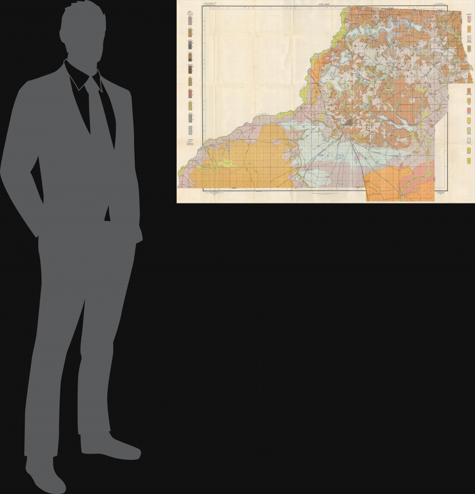
1905 Bureau of Soils Map of Leon County and Tallahassee, Florida
LeonCountyFL-bureausoils-1905$400.00


Title
Soil map, Florida, Leon County sheet.
1905 (dated) 29.5 x 43.5 in (74.93 x 110.49 cm) 1 : 63360
1905 (dated) 29.5 x 43.5 in (74.93 x 110.49 cm) 1 : 63360
Description
A large and colorful soil map of Leon County, Florida, including Tallahassee, produced by the Bureau of Soils in 1905. It carefully catalogs the area's sandy soils, part of a broader effort to survey Florida's soils in the early 20th century.
A Closer Look
Situated near center is Tallahassee, with several railroad lines emanating from it. Lakes, rivers, creeks, towns, roads, railroad lines, and other features are noted throughout. individual properties are marked, and crosses indicate the location of churches, highlighting the county's relatively low population density. Colors correspond to the various types of soil found in the region, most of which are of a sandy character.Publication History and Census
This map was produced by the U.S. Department of Agriculture's Bureau of Soils in 1905 and appeared in the Bureau's 1906 publication Soil survey of Leon County, Florida (OCLC 1845834). Brigham Young University, the University of Chicago, the University of South Florida, and the Touchton Map Library at the Tampa Bay History Center catalog the map independently, while ten institutions list the entire Soil survey publication among their holdings.CartographerS
Milton Whitney (1860 - November 11, 1927) was a soil surveyor and the inaugural Chief of the Division of Agricultural Soil in the U.S. Department of Agriculture's Weather Bureau, the predecessor to the Bureau of Soils (which has itself evolved into today's National Cooperative Soil Survey). Beginning his career as a Professor of Geology and Soil Physics at the Maryland Agricultural College, Whitney took unconventional stances, proven to be correct with time, that gained him attention in the field and made him a logical choice to lead the USDA's soil bureau when it was established in 1894. He continued to publish research and propose innovative solutions to vexing problems, some of which proved to be inaccurate but led other researchers to test similar theories on soils that were eventually vindicated. More by this mapmaker...
Julius (Julien) Bien (September 27, 1826 - December 21, 1909) was a German-Jewish lithographer and engraver based in New York City. Bien was born in Naumburg, Germany. He was educated at the Academy of Fine Arts, Cassell and at Städel's Institute, Frankfurt-am-Main. Following the suppression of the anti-autocratic German Revolutions of 1848, Bien, who participated in the pan-German movement, found himself out of favor in his home country and joined the mass German immigration to the United States. Bien can be found in New York as early as 1849. He established the New York Lithographing, Engraving & Printing Company in New York that focused on the emergent chromo-lithograph process - a method of printing color using lithographic plates. His work drew the attention of the U.S. Government Printing Office which contracted him to produce countless government maps and surveys, including the Pacific Railroad Surveys, the census, numerous coast surveys, and various maps relating to the American Civil War. Bien also issued several atlases both privately and in conjunction with a relation, Joseph Bien. At the height of his career Bien was elected president of the American Lithographers Association. After his death in 1909, Bien's firm was taken over by his son who promptly ran it into insolvency. The firm was sold to Sheldon Franklin, who, as part of the deal, retained the right to publish under the Julius Bien imprint. In addition to his work as a printer, Bien was active in the New York German Jewish community. He was director of the New York Hebrew Technical Institute, the New York Hebrew Orphan Asylum, and president of the B'nai B'rith Order. Learn More...
Source
Wilder, Henry J. et al, Soil survey of Leon County, Florida, (Washington D.C.: Government Printing Office) 1906.
Condition
Very good. Some creasing along fold lines.
References
OCLC 85775370, Touchton Map Library L2018.105.081.