Digital Image: 1755 Stow Map of Tower Street Map, London
LondonTowerStreet-stow-1755_d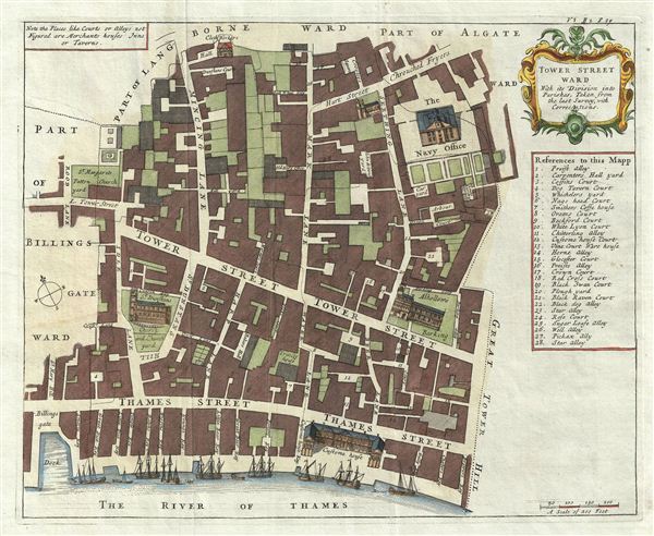

Title
Tower Street Ward With its Division into the Parishes, Taken from the last Survey with Corrections.
1720 (dated) 21.5 x 15.5 in (54.61 x 39.37 cm)
1720 (dated) 21.5 x 15.5 in (54.61 x 39.37 cm)
Description
FOR THE ORIGINAL ANTIQUE MAP, WITH HISTORICAL ANALYSIS, CLICK HERE.
Digital Map Information
Geographicus maintains an archive of high-resolution rare map scans. We scan our maps at 300 DPI or higher, with newer images being 600 DPI, (either TIFF or JPEG, depending on when the scan was done) which is most cases in suitable for enlargement and printing.
Delivery
Once you purchase our digital scan service, you will receive a download link via email - usually within seconds. Digital orders are delivered as ZIP files, an industry standard file compression protocol that any computer should be able to unpack. Some of our files are very large, and can take some time to download. Most files are saved into your computer's 'Downloads' folder. All delivery is electronic. No physical product is shipped.
Credit and Scope of Use
You can use your digial image any way you want! Our digital images are unrestricted by copyright and can be used, modified, and published freely. The textual description that accompanies the original antique map is not included in the sale of digital images and remains protected by copyright. That said, we put significant care and effort into scanning and editing these maps, and we’d appreciate a credit when possible. Should you wish to credit us, please use the following credit line:
Courtesy of Geographicus Rare Antique Maps (https://www.geographicus.com).
How Large Can I Print?
In general, at 300 DPI, you should at least be able to double the size of the actual image, more so with our 600 DPI images. So, if the original was 10 x 12 inches, you can print at 20 x 24 inches, without quality loss. If your display requirements can accommodate some loss in image quality, you can make it even larger. That being said, no quality of scan will allow you to blow up at 10 x 12 inch map to wall size without significant quality loss. For more information, it is best consult a printer or reprographics specialist.
Refunds
If the high resolution image you ordered is unavailable, we will fully refund your purchase. Otherwise, digital images scans are a service, not a tangible product, and cannot be returned or refunded once the download link is used.
Cartographer S
John Stow (c. 1525 – April 6, 1605) was an Elizabethan historian and antiquarian. He was born the son of a poor tallow-chander in the parish of St. Michael, Cornhill, London. As a young man he apprenticed as a tailor and in 1547 was admitted into the Merchant Taylor's Company. He established himself in Aldgate and later moved to the Lime Street Ward, where he lived to his death. Exhibiting a penchant for scholarship, Stow developed a strong interested in antiquarian studies and became friends with most of the great British historians of his day, including William Camden. His extensive research library, the work of many years in compiling, brought him under suspicion of the church, who considered many of the works "in defense of papistry". While there were numerous attempts to persecute him, Stow managed to avoid any serious repercussions for his book collection and in fact published several important histories. In cartographic circles, Stow is best known for his Survey of London, which was first published in 1598 and subsequently updated and reissued in 1603. The Survey was not just an atlas of London, for it also included amusing anecdotes, highly detailed descriptions of buildings, and comments on social conditions in Elizabethan London. The work proved popular and went through two editions in Stow's lifetime. Following his death, however, London was transformed by enormous growth and the devastating of the Great Fire of 1666. Stow's survey was subsequently redrawn and reissued by John Strype in 1720. More by this mapmaker...
Server Error
404
Page Not Found
This page either doesn't exist, or it moved somewhere else.
That's what you can do
John Strype (November 1, 1634 – December 11, 1737) was a Huguenot clergyman, cartographer, biographer, and historian active in London during the late 17th and early 18th century. Like many Huguenots, Strype's family fled to England to escape religious prosecution in Brabant. They established themselves as textile merchants in Petticoat Lane – their street eventually became known as Strype Street. John was educated at St. Pauls School and later at Cambridge's Jesus College and St. Catherine's College. He lived most of his life in Leyton, north London, where he worked as a curate and lecturer of Leyton. He published numerous historical works relating to the Protestant Reformation. His most significant cartographic contribution his is c. 1720 republication of John Stow's Survey of the Cities of London and Westminster. Learn More...
Source
Strype, J., Survey of England (London) 1720.