This item has been sold, but you can get on the Waitlist to be notified if another example becomes available, or purchase a digital scan.
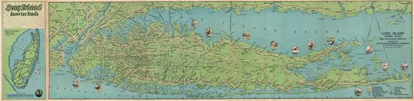
1928 McNally Map of the Long Island, New York, Sunrise Trails
LongIslandSunrise-randmcnally-1928$100.00

Title
Long Island Sunrise Trails.
1928 (undated) 9 x 36.5 in (22.86 x 92.71 cm)
1928 (undated) 9 x 36.5 in (22.86 x 92.71 cm)
Description
A beautiful example of Rand McNally's 1928 map of the Long Island Sunrise Trails. This folding map coves Long Island from Staten Island to Montauk Point in Long Island and includes Manhattan, and parts of adjacent Westchester and New Jersey. The map features main and secondary roads, auto and passenger ferry routes, railroads, golf clubs and state parks. Throughout beautiful pictorial decorations are featured. Verso contains two inset maps, one of Through Routes to Long Island and the other of Gateways to Long Island. Verso also contains ferry schedules, index of gold clubs and state parks and a rate card for local newspapers. The map is beautifully colored with the cover showing the island's main and secondary highways. The map is copyrighted by Rand McNally & Company and issued by the Long Island Chamber of Commerce, 20 West 34th Street, New York.
Cartographer
Rand, McNally and Co. (fl. 1856 - present) is an American publisher of maps, atlases and globes. The company was founded in 1856 when William H. Rand, a native of Quincy, Massachusetts, opened a print shop in Chicago. Rand hired the recent Irish immigrant Andrew McNally to assist in the shop giving him a wage of 9 USD per week. The duo landed several important contracts, including the Tribune's (later renamed the Chicago Tribune) printing operation. In 1872, Rand McNally produced its first map, a railroad guide, using a new cost effective printing technique known as wax process engraving. As Chicago developed as a railway hub, the Rand firm, now incorporated as Rand McNally, began producing a wide array of railroad maps and guides. Over time, the firm expanded into atlases, globes, educational material, and general literature. By embracing the wax engraving process, Rand McNally was able to dominate the map and atlas market, pushing more traditional American lithographic publishers like Colton, Johnson, and Mitchell out of business. Eventually Rand McNally opened an annex office in New York City headed by Caleb S. Hammond, whose name is today synonymous with maps and atlases, and who later started his own map company, C. S. Hammond & Co. Both firms remain in business. More by this mapmaker...
Condition
Very good. Original fold lines visible.