1915 Clason Map of Los Angeles, Panama-Pacific and Panama-California Exposition
LosAngeles-clason-1915$500.00

Title
Map of Los Angeles City, also a District Map showing Automobile Roads, etc. - and a Map of the 1915 Exposition Trail / Map of Los Angeles, the Shoe String Strip and the Los Angeles Harbor.
1915 (dated) 33.25 x 27.5 in (84.455 x 69.85 cm) 1 : 30100
1915 (dated) 33.25 x 27.5 in (84.455 x 69.85 cm) 1 : 30100
Description
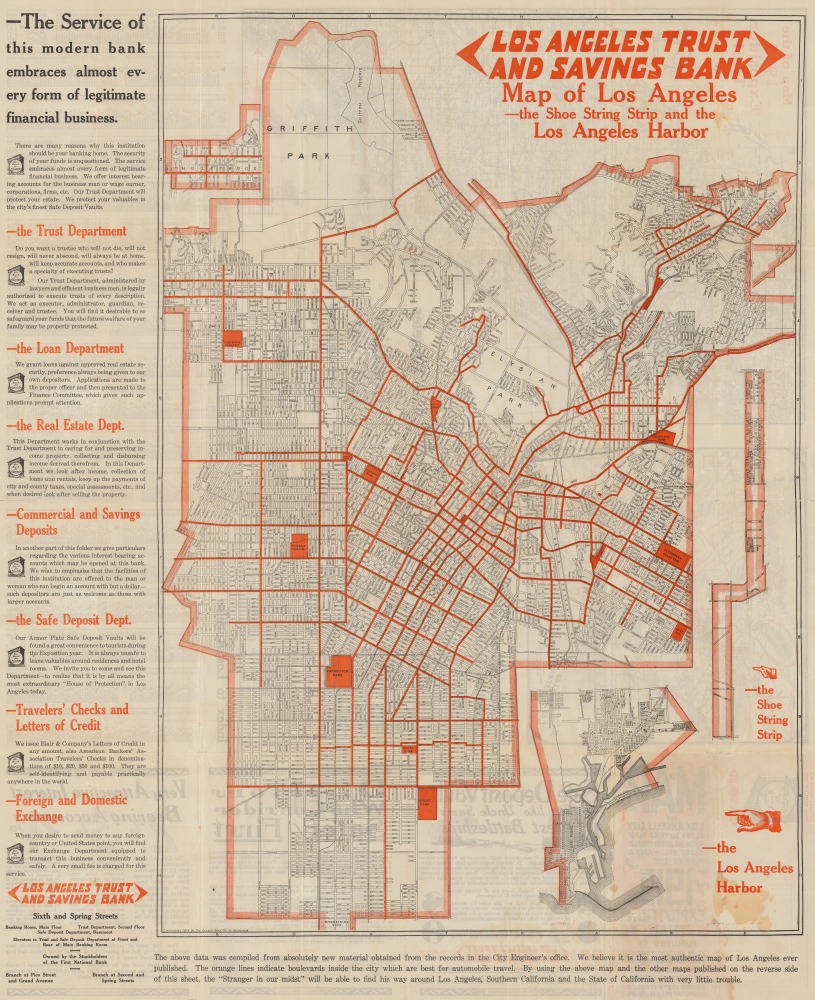
A scarce 1915 map of Los Angeles produced by the Clason Map Company. While focusing on L.A., it also promotes two concurrent, competing international expositions held that year in San Francisco and San Diego.
Lines belonging to the Los Angeles Railway (also known as the 'yellow cars'), which was at its apex around this time, are marked with solid black lines. The lines of the Pacific Electric Railway ('red cars'), typically longer-distance routes, as well as the Southern Pacific Railway and other railways are also indicated with dashed black lines. Thick orange lines display the roads considered best for automobile travel, a sign of the shifting preferred means of transportation. Parks are also marked out in orange (Exposition Park was so christened because of the state agricultural expositions held there, not the 1915 expositions).
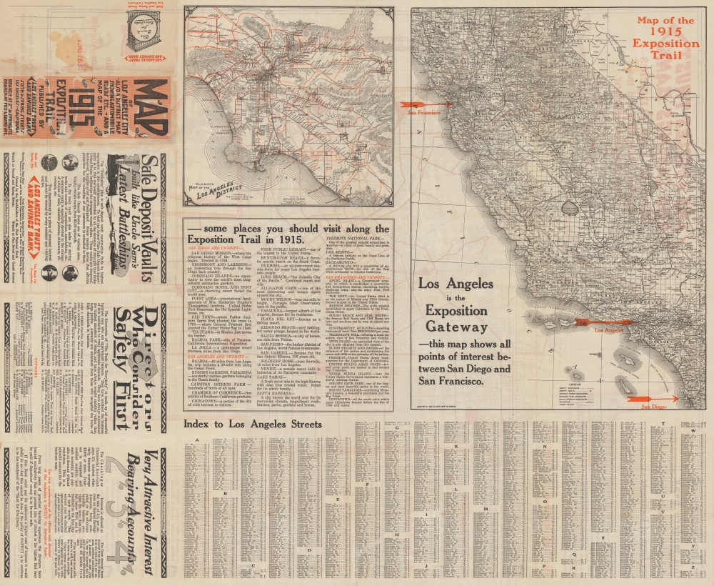
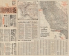
The verso includes a map of the 'Los Angeles District' highlighting the wider region and demonstrating the scope of the Pacific Electric Railway network (in black) and the region's road network (in orange), such as it was at the time. At right is a road map of California displaying railroads, 'wagon roads', county lines and internal subdivisions, national parks, and more. Both the recto and verso include advertising from the publisher and sponsor, the Los Angeles Trust and Savings Bank.
This map demonstrates creative marketing on the part of its makers by promoting an 'Exposition Trail' linking the two competing expositions. Conveniently located between San Diego and San Francisco, Los Angeles would be a convenient stop (obligatory for any train traveler) between the two cities and could thus benefit despite not hosting either exposition.
A Closer Look
This large map of the City of Los Angeles is notable for its layout and insets, as well as its reflection of the city borders at the time, prior to major expansions to the west. Griffith Park, still in its formative stages (due in part to its namesake's legal troubles), stands out prominently at top. Insets at top and bottom include Hollywood, the 'shoe string strip' leading to Los Angeles Harbor, and the harbor itself at San Pedro (in subsequent decades, the city would expand in several directions, especially to the west, all the way to the Pacific Ocean). A grid surrounds the map, corresponding to an index of street names on the verso.Lines belonging to the Los Angeles Railway (also known as the 'yellow cars'), which was at its apex around this time, are marked with solid black lines. The lines of the Pacific Electric Railway ('red cars'), typically longer-distance routes, as well as the Southern Pacific Railway and other railways are also indicated with dashed black lines. Thick orange lines display the roads considered best for automobile travel, a sign of the shifting preferred means of transportation. Parks are also marked out in orange (Exposition Park was so christened because of the state agricultural expositions held there, not the 1915 expositions).
The verso includes a map of the 'Los Angeles District' highlighting the wider region and demonstrating the scope of the Pacific Electric Railway network (in black) and the region's road network (in orange), such as it was at the time. At right is a road map of California displaying railroads, 'wagon roads', county lines and internal subdivisions, national parks, and more. Both the recto and verso include advertising from the publisher and sponsor, the Los Angeles Trust and Savings Bank.
A Tale of Two Expositions
Towards the end of the first decade of the 20th century, both San Francisco and San Diego proposed plans to host an international exposition to celebrate the coming completion of the Panama Canal. The two cities were hardly comparable. San Francisco was much larger and better known internationally and had the added incentive of a desire to celebrate the city's recovery from the destructive earthquake and fire of 1906. But planners in San Diego pressed ahead, even while lacking the backing and funding from both the state and federal government that San Francisco's exposition enjoyed. In the end, however, funding from bond measures and determination by the San Diego planners resulted in an impressive event (lasting throughout 1915 and 1916), even if it has been far less remembered than its San Francisco rival (February - December 1915). Balboa Park was completely remade and several of the exposition's structures were retained permanently (more than in San Francisco), while the exposition's exotic animal displays laid the foundation for the world-renowned San Diego Zoo.This map demonstrates creative marketing on the part of its makers by promoting an 'Exposition Trail' linking the two competing expositions. Conveniently located between San Diego and San Francisco, Los Angeles would be a convenient stop (obligatory for any train traveler) between the two cities and could thus benefit despite not hosting either exposition.
Publication History and Census
This map was produced by the Clason Map Company, modifying an earlier map copyrighted 1910 on the recto and two copyrighted 1910 and 1911, respectively, on the verso. It was published by the Los Angeles Trust and Savings Bank. This is a rare map, scarce to the market with only one known institutional holding, at the California Historical Society.Cartographer
George Samuel Clason (November 7, 1874 - 1957) was born in the city of Louisiana, Missouri in 1874. As a young man, Clason studied at the University of Nebraska before joining the United States Army in 1898 to fight in the Spanish American War. After the war, he moved to Denver, Colorado where in 1905 he founded the Clason Map Company, thus starting his lucrative publishing career. Clason initially focused on mining and mineral maps - capitalizing on the Colorado and Nevada mining industry, but quickly transitioned to railroad maps, city maps, and by the 1920s, road maps. As the company expanded, Clason opened a secondary office in Chicago, Illinois - then a rising map publishing center and railroad hub. At least one other satellite office was opened in Los Angeles. Among his many achievements, Clason is credited with producing the first modern road atlas of the United States. In the late 1920s, Clason also published a series of get-rich-quick pamphlets in the form of parables. The most famous of these is The Richest Man in Babylon. This tells the story of Arkad, a citizen of Babylon famed for his great wealth and generosity who shares his wit and wisdom with his fellow Babylonians. In 1949, Clason moved to Napa, California to retire and found a social club for retired gentlemen. More by this mapmaker...
Condition
Very good. Archival verso repairs along some fold intersections and margins. Slight loss reinstatement on verso near the 'on' in 'Exposition'. Old discoloration lower right corner.
References
OCLC 950739426.