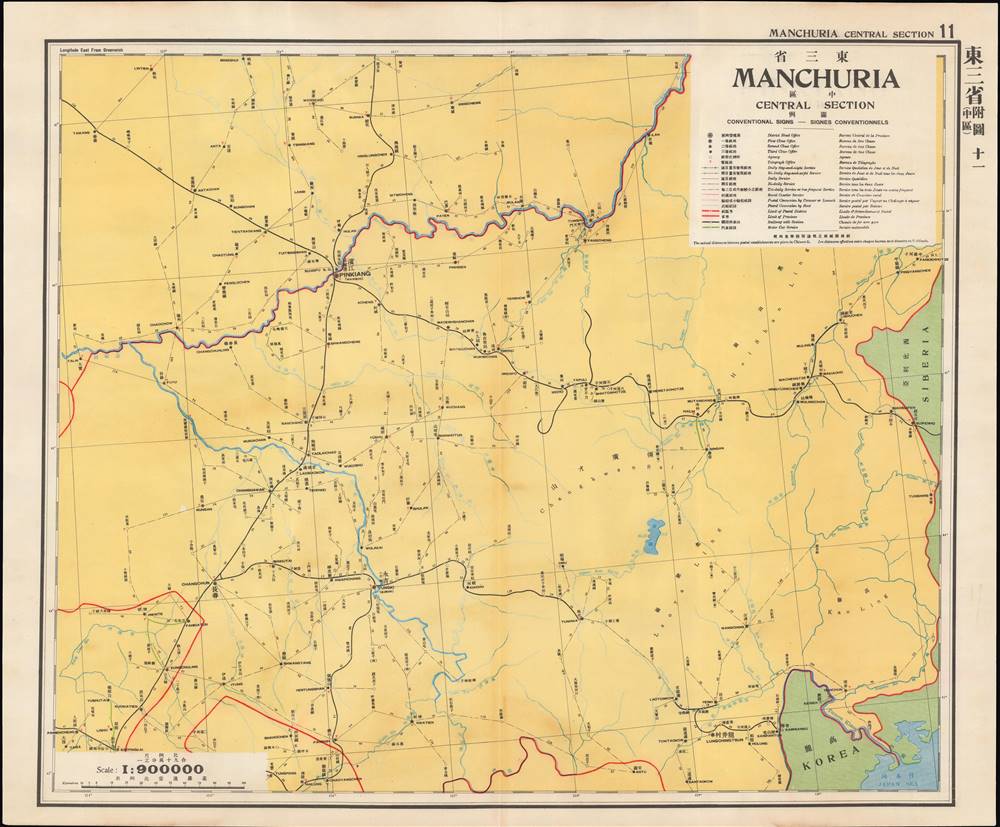
Title
東三省 中區 / Manchuria Central Section.
1933 (undated)
24.25 x 29.25 in (61.595 x 74.295 cm)
1 : 900000
Description
This is a map of central Manchuria (portions of Heilongjiang and Jilin Provinces) from the 1933 edition of The Postal Atlas of China (中華郵政輿圖), compiled by Charles Jacot-Guillarmod. It highlights the evolving postal infrastructure of the region, which had been contested between China, Japan, and Russia for decades and had become a de facto Japanese colony with the establishment of the puppet state of Manchukuo the previous year.
Manchuria - Nexus of Northeast Asia
This map was made at a time of great upheaval (described below) for the lands illustrated here. As the atlas was published by a wing of the Chinese government, Japanese imperial gains in northeastern China are not recognized, nor are the changes in placenames that followed, such as the renaming of Changchun to Xinjing (新京, 'new capital'). In fact, the map's title uses the somewhat anachronistic title 'Three Eastern Provinces' (東三省), a Qing-era administration that had been expanded with the addition of a fourth province, Rehe (熱河省, often Jehol in foreign sources), in 1928.
Some sense of the openness of the region is given here, even after decades of migration from other parts of China. Infrastructure is minimal, and to the extent that it does exist it is oriented around major rivers and railways. Harbin (here as Pinkiang 濱江), in particular, sprang up in tandem with the railways and the city's culture and economy remained deeply tied to the railway network of Manchuria.Mantetsu, the Kwantung Army, and Manchuria
The Treaty of Portsmouth that ended the Russo-Japanese War (1904 - 1905) granted to Japan, among other rights, the Kwantung Leased Territory and the southern section of the China Eastern Railway, from Changchun (長春) to Port Arthur (旅順 Lüshun), which became known as the South Manchuria Railway (the northern section between Harbin and Changchun was jointly managed by Russia and China and came to be known as the North Manchuria Railway, 北滿鐵路). The company created to manage the southern section, the South Manchuria Railway Company (Mantetsu), soon developed into a mega-conglomerate that oversaw hotels, mines, mills, power plants, publishing, and much more, expanding Japanese influence in Manchuria to the point that it became a virtual colony. By the 1930s, Mantetsu was the largest company in Japan and by itself formed a significant portion of the Japanese economy.
Although Japan already exercised an informal empire in much of Manchuria, the territory was still under the control of the Fengtian Clique of warlords, led by Zhang Zuolin. Meanwhile, a sizable Japanese garrison occupied the Kwantung Leased Territory, known as the Kwantung Army (or Kantō-gun in Japanese). The Kwantung Army was a hotbed of ultranationalism, militarism, and anti-democratic secret societies, and produced several of Japan's future wartime leaders, including Tōjō Hideki. Although the Kwantung Army had initially supported Zhang Zuolin as a bulwark against Chiang Kai-Shek, who was seen as pro-Communist, he was assassinated soon after Chiang nominally reunified the country in 1928 when a bomb exploded under his private train traveling on the South Manchuria Railway. The plot had been hatched by junior officers in the Kwantung Army.
Three years later, on September 18, 1931, a group of Kwantung Army officers staged a false flag incident (another bombing along the South Manchuria Railway) to provide a pretext for invading and occupying Manchuria. Although Japan's political leaders and likely even the military leadership were unaware of the invasion plot, they did not force the Kwantung Army to retreat despite international condemnation because the invasion was extremely popular domestically and was a convenient solution to Japan's long-term problems with resource constraints and overpopulation.The Birth of Manchukuo
Rather than make Manchuria a formal colony, as with Taiwan, or annex it outright, as with Korea, a puppet regime was established, led by the last emperor of the Qing Dynasty, Aisin Gioro Puyi, who had been living in the Japanese Concession in Tianjin. Puyi had expressed his desire to be re-enthroned and had support from the now-minority population of Manchus, who felt discriminated against in China since the Qing Dynasty's collapse in 1912. After being denounced as a traitor by the Chinese government, Puyi was smuggled out of Tianjin in the trunk of a car and conveyed to Manchuria, where he became the nominal head of the new state.
A vast, sparsely populated region that was tremendously rich in resources, Manchuria became a wild, violent, multiethnic imperial frontier. Forced labor was employed on a mass scale under brutal conditions. All manner of warlord troops, bandits, and rebels were present in Manchuria following Japan's invasion, and extremely harsh methods were used to suppress resistance. A special military unit (Unit 731) even engaged in horrific experiments on living subjects (often captured rebels and enemy troops, though also randomly selected civilians), such as biological weapons, chemical warfare, and vivisection.
Despite the creation of a government led by Manchus and other non-Han ethnic groups, real power rested with Japanese military officers, bureaucrats, and the South Manchuria Railway. After the establishment of Manchukuo, Mantetsu was expanded to become the Manchukuo National Railway (滿洲國有鐵道). Since it was in a compromised position and difficult to administer, the Soviets relinquished their claim on the section between Harbin and Changchun (renamed Xinjing, as capital of Manchukuo) after considerable pressure in 1934. Afterwards, the National Railway quickly changed the gauge on the Harbin-Xinjing section (the North Manchuria Railway), from the wide 1,520mm Russian gauge to the standard 1,435mm gauge used elsewhere in Manchukuo.
Manchukuo quickly became a steppingstone to further Japanese aggression throughout China, just as Korea had been a steppingstone to Manchuria. In the end, rather than being a showcase of rapid industrialization and a beacon of Japan's agenda of progress for Asia, or a bastion for the beleaguered Manchus and other non-Han ethnicities, Manchukuo instead became the archetype for the false promises and cruelty of Japanese imperialism.The Postal Atlas of China (中華郵政輿圖)
Compiled by Charles Jacot-Guillarmod, this atlas contains maps covering all of China in considerable detail. Most were derived from regional working postal maps. The legends on the maps are written in English, Chinese, and French. The history of the The Postal Atlas of China is closely related to attempts to Romanize placenames in the Chinese Postal System. The first atlas followed the 1906 Shanghai Imperial Postal Joint-Session Conference to develop a system of Romanization following Herbert Giles' 'Nanking Syllabary.' The Giles 'Nanking syllabary' was popular with the French-dominated Chinese Postal Service, which considered the earlier Beijing based system developed by Thomas Francis Wade as too Anglophone. As was the case for other bureaucratic offices at this time, foreign advisors were often brought in as consultants or even government officials.
The second edition of the Postal Atlas was issued in 1919 following a Ministry of Education system to standardize the Beijing dialect in all elementary schools throughout China. This led to a resurgence of the Wade system. Nonetheless, in 1931, the French postal co-director Henri Picard-Destelain ordered a return to the Nanking Syllabary. The Chinese Postal System remained under French management until 1943 when the Japanese invaders ousted A. M. Chapelain, the last French head of the China Post.Publication History and Census
There are four known editions of this atlas: 1907-08 (Shanghai, replacing the 1903 postal wall map, 21 maps plus index map), 1919 (Beijing, 47 maps), 1933 (Nanjing), and 1936 (Nanjing). The atlas was compiled by the French topographical engineer Charles Jacot-Guillarmod and published by the Directorate General of Posts (郵政總局). This edition is held by a handful of university libraries and research institutions in North America and Europe, as well as institutions in mainland China and Taiwan.
Cartographer
Charles Jacot-Guillarmod (1868 – August 14, 1925) was a Swiss topographical engineer active in the late 19th and early 20th century. Charles was born in Le Chaux-de-Fonds, in the Canton of Neuchatel, Switzerland. He attended the Eidgenössische Technische Hochschule Zürich (ETHZ), where he acquired a degree in Topographical Engineering. After graduating served the Swiss Federal Topographical Bureau from 1890 – 1914, contributed significantly to the Topographical Atlas of Switzerland. He was dismissed from his government topographical posted in 1914. Independent of a paid post he turned his attentions to his interested in high alpine cartography, producing two topographical sketches of Himalayan peaks (K2 and Kanchenjunga) based upon photographs taken by his cousin, the famed mountaineer Jules Jacot-Guillarmod. From 1916 to 1922 he relocated to Beijing where he taught geodesy and topography at the Chinese Army Survey School. There, he was also contracted to compile the 1919 second edition of the China Postal Atlas. When the Chinese government could no longer pay him, he returned to Switzerland in 1923 where he compiled a large scale topographic map of Mount Olympus. His final work was a large scale map of Mount Everest commissioned by the Royal Geographical Society, London, based upon the surveying achievements of a British expedition. More by this mapmaker...
Source
China. You zheng zong ju, Zhonghua min guo you zheng yu tu, (Nanking: Directorate General of Post) 1933.
Condition
Very good. Some discoloration along central fold line and at top and bottom margins.
References
OCLC 5371414, 17468267.