This item has been sold, but you can get on the Waitlist to be notified if another example becomes available, or purchase a digital scan.
1898 Rand McNally Map of Manila Harbor, Spanish-American War
ManilaHarbor-randmcnally-1898$112.50


Title
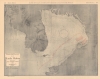
Rand-McNally Map of Manila Harbor.
1898 (dated) 19 x 24 in (48.26 x 60.96 cm) 1 : 221760
1898 (dated) 19 x 24 in (48.26 x 60.96 cm) 1 : 221760
Description
This is an uncommon 1898 Rand McNally map of Manila Harbor in the Philippines. The map illustrates the Battle of Manila, the historic 'turning of the tides' that ended nearly 300 years of Spanish dominion in the Philippines.
A Closer Look
The map depicts Manila Bay from its approaches in the South China Sea to Manila and the Pasig River and from Pampanga Bay to Limbones Point. By illustrating the naval battle between the American Asiatic Squadron and the Spanish Pacific Squadron in Manila Bay, Rand-McNally reinforces American dominance in the Pacific. The American Squadron, led by Commodore George Dewey, destroyed the Spanish squadron in one of the most decisive battles in naval history. The course of the 'United States Fleet' is illustrated in red, along with the position of the 'Spanish Fleet'. Depicted here are the Spanish batteries at Manila, Bakor, Canacao, Kalumpan Point, and Limbones Point, and others, all of which could bombard enemy forces in the bay. Locations around the bay are labeled, including Manila and Corregidor Island, which would play a critical role during World War II (1939 - 1945).The Battle of Manila
The American Asiatic Squadron under Commodore George Dewey engaged and destroyed the Spanish Pacific Squadron under Admiral Patricio Montojo. At 5:41 AM, with the now famous command, 'You may fire when ready, Mr. Gridley,' Commodore Dewey instructed Olympia's captain to begin the bombardment of the Spanish fleet. After a furious exchange, Gridley messaged Dewey that only 15 rounds of ammunition remained per gun. Concerned, Dewey ordered an immediate withdraw. So as not to alarm the crew, he announced that they were 'pausing for breakfast' - which they proceeded to enjoy. During this historic 'breakfast' it became apparent that the communication has gone awry and that the actual message was that Gridley has 'expended only 15 rounds of ammunition per gun.' The Battle commenced at 10:40 AM and followed with the surrender and destruction of the Spanish squadron. The Spanish colors were struck at 12:40 PM, ending 300 year of Spanish hegemony over the Philippines.Publication History and Census
This map was published by Rand, McNally in the 1898 edition of their Indexed Atlas of the World. We have been unable to locate any other cataloged examples of the separate map.Cartographer
Rand, McNally and Co. (fl. 1856 - present) is an American publisher of maps, atlases and globes. The company was founded in 1856 when William H. Rand, a native of Quincy, Massachusetts, opened a print shop in Chicago. Rand hired the recent Irish immigrant Andrew McNally to assist in the shop giving him a wage of 9 USD per week. The duo landed several important contracts, including the Tribune's (later renamed the Chicago Tribune) printing operation. In 1872, Rand McNally produced its first map, a railroad guide, using a new cost effective printing technique known as wax process engraving. As Chicago developed as a railway hub, the Rand firm, now incorporated as Rand McNally, began producing a wide array of railroad maps and guides. Over time, the firm expanded into atlases, globes, educational material, and general literature. By embracing the wax engraving process, Rand McNally was able to dominate the map and atlas market, pushing more traditional American lithographic publishers like Colton, Johnson, and Mitchell out of business. Eventually Rand McNally opened an annex office in New York City headed by Caleb S. Hammond, whose name is today synonymous with maps and atlases, and who later started his own map company, C. S. Hammond & Co. Both firms remain in business. More by this mapmaker...
Source
Rand, McNally and Co., Rand, McNally and Company's Indexed Atlas of the World, (Chicago) 1898.
Condition
Very good. Wear along original centerfold. Closed minor margin tear professionally repaired on verso. Text on verso.